FISC - St. Petersburg
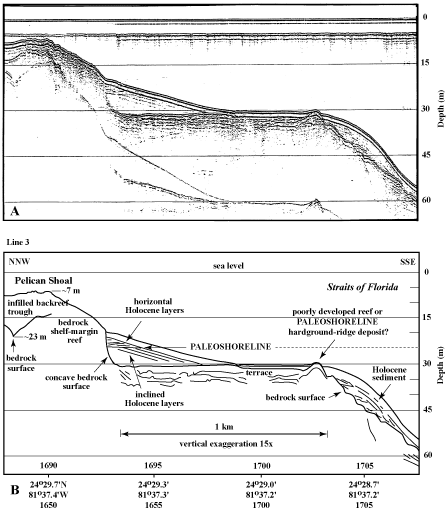
Figure 94. (A) Seismic-reflection profile (1989) and (B) interpretation show upper-slope terrace off Pelican Shoal (lower Keys; from Lidz et al., 2003; Figs. 86C, 87B, 91B). Profile crosses the shelf margin nearly normal to a single outlier-reef tract at Eastern Sambo and Maryland Shoal (Fig. 89, lines 2 and 4, and Fig. 95A) and ~20 km east of the multiple outliers off Sand Key Reef (Fig. 18 and Tile 7/8). Note facies change in sediment wedge on terrace. Horizontal layers are interpreted to result from a stillstand of sea level that eroded tops of the inclined strata and redeposited the sands in an intertidal zone (Lidz et al., 2003). Note smoothness of the reflection marking a mounded bedrock surface buried at the seaward terrace edge. The mound is interpreted to represent a cemented dune ridge that was not colonized by corals. For comparison, note jagged nature of reflection across known Holocene shelf-edge corals (e.g., Fig. 95A, 95B). Latitude and longitude in degrees and decimal minutes based on GPS coordinates. Hours (military time) below coordinates serve as navigational correlation points along seismic line.
|
Can't see the printable PDF version? Get the free Adobe Acrobat® Reader. |

![]() U.S. Department of the Interior |
U.S. Geological Survey
U.S. Department of the Interior |
U.S. Geological Survey
URL: [disc] /pubs/pp/2007/1751/professional-paper/tile6/figures/fig94.html
Page Contact Information: Feedback
Page Last Modified: December 01, 2016 @ 04:14 PM (JSS)
