


The purpose of these interpretive discussions is to provide a perspective on regional- and national-scale variations in element and mineral distributions in soils and their likely causes. The significant spatial variations shown by most elements and minerals can commonly be attributed to geologic sources in underlying parent materials, but other spatial variations seem clearly related to additional factors such as climate, the age of soils, transported source material, and anthropogenic influences. We attempt to distinguish the influence of these various factors on a regional and national scale. Numerous more local features might similarly be related to these same factors, but these features also have some probability of being an artifact of a random sampling of variable compositions, so that there is some probability of samples with similar compositions occurring in clusters of two or more adjacent sites by chance. Distinguishing such random occurrences from true variability is beyond the scope of the data from which these maps are constructed. Some caution, therefore, is advisable in interpreting the significance of these more local features unless some unique sources or processes can clearly be related to them.
Scandium (Sc) is a common trace element in rocks of the Earth's crust and in the soils derived from them. It shares chemical properties with aluminum (Al) and its distribution in soils mimics the distribution of that metal in part. Small quantities of Sc are used mainly as a trace constituent of specialized alloys. It has no known health effects at normal environmental exposure levels.
The abundance of Sc in the Earth's upper continental crust is estimated to be about 14 milligrams per kilogram (mg/kg) (Hu and Gao, 2008). On average, Sc is most concentrated in mafic rocks (35–40 mg/kg) and is much less concentrated in granitic rocks and most sedimentary rocks (1–15 mg/kg). Scandium occurs as a trace element in many aluminosilicate minerals, particularly clays, micas, and pyroxenes. Much of its pattern of higher and lower concentrations across the United States correlates with the abundance of these minerals.
The distribution of mineral resource deposits with Sc as a commodity (major or minor) in the United States, extracted from the U.S. Geological Survey (USGS) Mineral Resource Data System (MRDS) website, can be seen by hovering the mouse here. Statistics and information on the worldwide supply of, demand for, and flow of Sc are available through the USGS National Minerals Information Center (NMIC) website.
For our data, the median concentrations of Sc in all sample types (6.1 mg/kg for the top 0- to 5-cm layer and soil A horizon, 7.3 mg/kg for soil C horizon) are well below the estimated upper continental crustal abundance (see the summary statistics [open in new window]). This appears to be consistent with the widespread occurrences of sedimentary and granitic rocks across the country, which typically carry low concentrations of Sc.
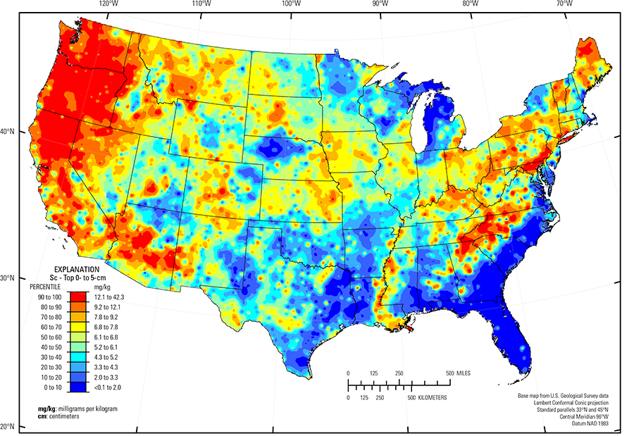
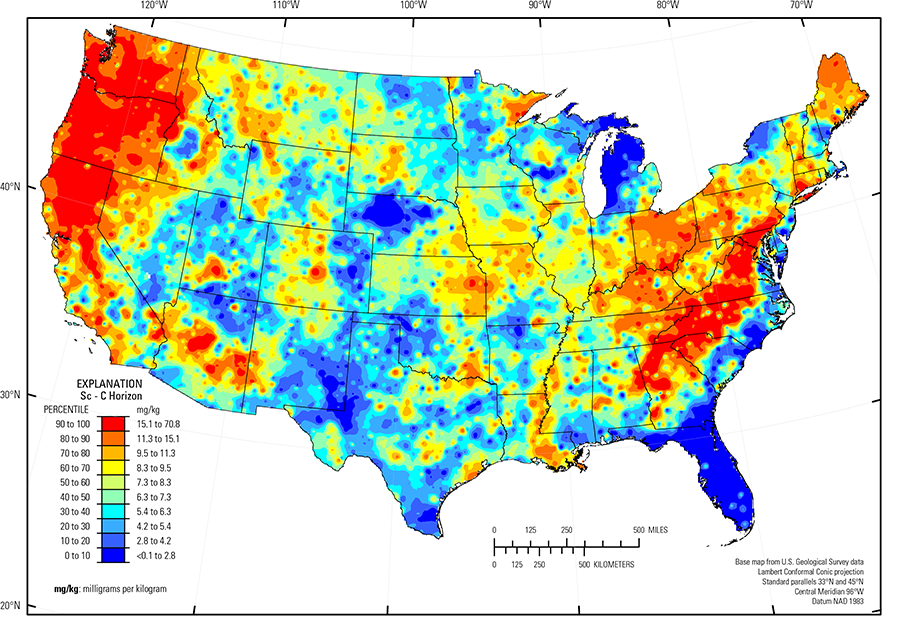
The distribution of Sc in soils of the conterminous United States appears to be controlled very largely by the chemical composition and mineralogy of parent material and no human impact can be detected at the national scale. Areas of relatively elevated Sc concentrations in the eastern United States correspond quite closely with soils rich in the clay mineral kaolinite in the Piedmont physiographic province (Fenneman and Johnson, 1946) and the Central Allegheny Plateau (USDA, 2006) region, indicating that Sc likely is a trace constituent in kaolinite and has perhaps been concentrated within the deeply weathered residual deposits of that region. The relatively Sc–rich soils in the western United States also occur in kaolinite–rich soils in northern California, Oregon, and Washington. But the wider distribution of these Sc–rich soils corresponds with soils derived in large part from geologically young volcanic rocks, which contain substantial amounts of the mineral pyroxene, another mineral that can contain trace amounts of Sc.
Other areas with elevated Sc concentrations in soil are:
- Mogollon Transition (USDA, 2006), Arizona, an area containing mafic and intermediate igneous rocks;
- Duluth Complex, Minnesota a suite of pyroxene–bearing mafic igneous intrusions; and
- Generally clayey soils developed on the Southern Mississippi River Alluvium (USDA, 2006) and in Missouri and eastern Nebraska, Ohio, and northern Maine.
The lowest Sc concentrations in soils are in:
- Nebraska Sand Hills (USDA, 2006), an area of quartz– and plagioclase–rich unconsolidated sand dunes and sand sheets;
- Southern High Plains USDA, 2006), eastern New Mexico and northwestern Texas, an area of quartz–rich eolian sands and alluvial sediments;
- Sandy soil of the glaciated Upper Midwest in northern and central Wisconsin, and northern and eastern Michigan; and
- Most of the soils in the Gulf and Atlantic Coastal Plain (Fenneman and Johnson, 1946) that developed on quartz–rich sedimentary rocks and unconsolidated sediment.
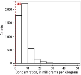
Statistics - 0 TO 5 CM
| Number of samples | 4,841 |
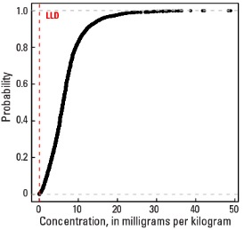
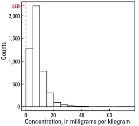
| LLD | 0.1 mg/kg |
| Number below LLD | 20 |
| Minimum | <0.1 mg/kg |
| 5 percentile | 1.2 mg/kg |
| 25 percentile | 3.8 mg/kg |
| 50 percentile | 6.1 mg/kg |
| 75 percentile | 8.4 mg/kg |
| 95 percentile | 15.6 mg/kg |
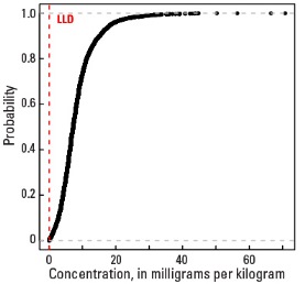
| Maximum | 42.3 mg/kg |
| MAD | 3.41 mg/kg |
| Robust CV | 55.9% |
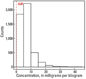
Histogram
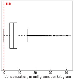
Boxplot
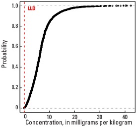
Empirical cumulative distribution function
Statistics - A Horizon
| Number of samples | 4,813 |
| LLD | 0.1 mg/kg |
| Number below LLD | 10 |
| Minimum | <0.1 mg/kg |
| 5 percentile | 1.3 mg/kg |
| 25 percentile | 3.9 mg/kg |
| 50 percentile | 6.1 mg/kg |
| 75 percentile | 8.5 mg/kg |
| 95 percentile | 15.5 mg/kg |
| Maximum | 48.9 mg/kg |
| MAD | 3.41 mg/kg |
| Robust CV | 55.9 % |
Histogram
Boxplot
Empirical cumulative distribution function
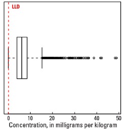
Statistics - C Horizon
| Number of samples | 4,780 |
| LLD | 0.1 mg/kg |
| Number below LLD | 9 |
| Minimum | <0.1 mg/kg |
| 5 percentile | 1.6 mg/kg |
| 25 percentile | 4.8 mg/kg |
| 50 percentile | 7.3 mg/kg |
| 75 percentile | 10.3 mg/kg |
| 95 percentile | 18.4 mg/kg |
| Maximum | 70.8 mg/kg |
| MAD | 4 mg/kg |
| Robust CV | 54.8 % |
Histogram

Boxplot