Readme first | Table of contents | Glossary | Geology | Depositional model | Heterogeneity | Diagenetic history | Petroleum geology | 1) East-West porosity slices | 2) North-South porosity slices | 3) Onion views of 3-D images | 4) Horizontal slices of porosity | 5) Horizontal and East-West permeability and porosity slices | Technical information
GEOLOGY OF THE SUSSEX SANDSTONE
ABSTRACT
The Upper Cretaceous Sussex "B" sandstone was deposited as a probable transgressive-marine sand-ridge complex in a mid-shelf position. The "B" sandstone is bounded by upper and basal disconformities and encased in mudstones and low-porosity and low-permeability sandstones of the Cody Shale. Reservoir characteristics are controlled primarily by depositional and diagenetic heterogeneity at megascopic (field), macroscopic (well), and microscopic (rock sample) levels. To simplify, this means production of oil is controlled by stacking and interbedding of sandstone and mudstone beds and by geochemical changes through time that affect flow of fluids through the rock.
More than 24.8 million barrels of oil (MMBO) have been produced from the Sussex "B" sandstone in the House Creek field, Powder River Basin, Wyoming. Greatest oil production, porosity, and permeability, the thickest reservoir sandstone intervals, and best lateral continuity of the primary reservoir facies are all located parallel and proximal to field axes. Decrease in reservoir quality west of the axes is due to greater heterogeneity from interbedding of low- and moderate-depositional-energy facies, with associated drop in porosity and permeability. Decrease in production east of the axes results primarily from a combination of seaward thinning of the primary reservoir facies and non-deposition of sand ridges.
The House Creek field has two axis orientations; these are related to depositional patterns of the four sand ridges. Deposition of the "B" sandstone began in the southeastern corner of the field with sand ridge 1; axis orientation is about north 20 degrees west. Later-deposited sand ridges 2 through 4 are located west and north of sand ridge 1; their axis orientations are approximately north 32 degrees west. Progressive northward deposition of later sand ridges is probably concurrent with uplift of the northeast-trending Belle Fourche arch. Movement along the arch and of lineaments may have caused topographic highs that localized Sussex and Shannon deposition proximal to the arch.
INTRODUCTION
Three-dimensional images and stand-alone movies reveal porosity and permeability distribution within, and stacking patterns of sand ridges. These models show:
- The field and sand-ridge outlines, thickness and interbedding of sandstone/mudstone intervals, color codes for porosity, permeability, and production intervals, and index maps with location in the field of reservoir slices,
- Upward and seaward increase in depositional energy, porosity, permeability, and production for each sand ridge,
- Concentration parallel and proximal to field axes of the greatest production, and thickness and lateral continuity of reservoir-grade sandstones, and
- Reservoir compartmentalization resulting from laterally continuous permeability barriers between sand ridges. Permeability barriers are mainly the low-depositional-energy mudstone and calcite-cemented sandstone facies that are concentrated toward the base of sand ridges.
Images and movies displaying 3-D slices of the porosity and permeability models of the Sussex "B" sandstone are tied to descriptions of Powder River Basin and Sussex "B" sandstone geology, statistics on porosity and permeability distribution across the field, and images of core, outcrops, and thin-section and SEM photomicrographs. The purposes are to characterize relative influence of depositional and diagenetic processes on distribution of hydrocarbons in the House Creek field and to visualize these processes. Technical information on geologic, geochemical, and computer geologic methods of analysis are detailed in Technical information on data sources (techinfo.htm). Diagenetic and depositional environment research (Higley, 1994) is based on petrographic analysis of about 60 thin sections, carbon and oxygen isotopic analysis of about 20 samples of carbonates, cathodoluminescence, SEM, and X-ray diffraction studies, and core, outcrop, and well-log studies. Well-logs for approximately 500 boreholes in the field area and 120 within the House Creek and Porcupine oil fields were used to map locations of the Ardmore bentonite, tops and bases of the Sussex "B" sandstone and included sand ridges, and well-history data. Sussex and Shannon Sandstones Members core porosity and permeability data was derived for 37 wells; this information for 13 Sussex "B" sandstone intervals augmented well-log porosity data for an additional about 90 wells.
As detailed in Readme First (readme1.htm), links among text, images, and movies are accomplished with pointing and clicking with computer mouse buttons. An asterisk (*) indicates a longer or variable file name. Most image files are saved in separate directories in Targa (*.tga and *.TGA) and GIF (*.gif and *.GIF) graphic formats. Images within this Geology of the Sussex Sandstone section and subsections are located in the "ssx_gif" and "ssx_tga" directories and are generally saved as full-size and scaled-down images. The "scaled down" images are half or less the dimensions and file size of the full-scale ones; they are accessed more quickly on this CD-ROM then are the large images. File names and sizes accompany figures.
BACKGROUND GEOLOGY
The Powder River Basin of Wyoming and Montana is an asymmetric Laramide-age structural basin with a steeply dipping western flank and a gently dipping eastern flank. The Upper Cretaceous Cody Shale, including the Sussex Sandstone Member and its age equivalents, underlies most of the Powder River Basin and outcrops along the western flank, west of the outcrops of Lance Formation and Fox Hills Sandstone shown as shaded fill on figure 1. The informally named Sussex "B" sandstone unit of the Sussex Sandstone Member has a limited areal extent that is approximated by the outlines of the House Creek and Porcupine oil fields shown on figure 1.
The House Creek field is located on the gently-dipping eastern flank of the Powder River Basin in Wyoming. The field trends about N. 40 degrees W., approximately parallel to present-day basin structure contours. It is about 1 mi (1.6 km) wide and, combined with the small Porcupine field at the southern boundary, is about 36 mi (58 km) long. A narrow zone of non-oil-productive, low-permeability marine mudstone separates these two fields. Oil from both fields is produced from the Upper Cretaceous Sussex "B" sandstone. Depths of the Sussex "B" sandstone in the fields ranges from about 7,000 to 9,000 ft (2,100 to 2,700 m), and in thickness up to 52 ft (16 m); average thickness of the reservoir interval totals about 20 ft (6 m).
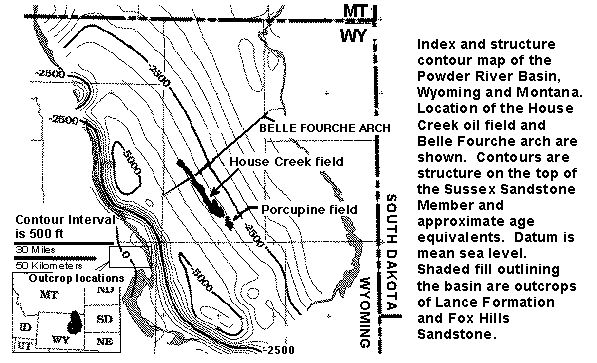
Figure 1. Structure contour map on the top of the Upper Cretaceous Sussex Sandstone Member of the Cody Shale, and approximate age equivalents, Powder River Basin, Wyoming and Montana. Location of the House Creek field is shown. Areal extent of the Sussex "B" sandstones is delineated by black-colored fields. Shaded fill outlining the basin are outcrops of Lance Formation and Fox Hills Sandstone. The rectangle located next to the 30-miles scale bar defines the area of studied outcrops of the Sussex and Shannon Members, much of the Salt Creek anticline, and the towns of Midwest and Edgerton. Contour interval is 500 ft. Datum is mean sea level. A detailed (176 KB) version is named indexfig.gif.
This reservoir characterization of the House Creek oil field integrates depositional energy and environments, facies distribution, and burial diagenesis. These factors influence petroleum production by controlling;
- Reservoir heterogeneity,
- Vertical and lateral continuity and compartmentalization of sandstones,
- Locations and types of permeability barriers,
- Directions of maximum fluid flow at field, sand ridge, and bedform scales,
- Porosity/permeability distributions, and
- Emplacement and trapping of oil across the field.
Cretaceous History of the Powder River Basin
The informally named Sussex "B" sandstone is one of as many as 12 separate sandstone bodies that are located at different vertical and lateral positions within the Sussex Sandstone Member (Anderman, 1976; Crews and others, 1976). Figure 2 is a generalized stratigraphic section for Cretaceous and Tertiary sediments in the basin, including major unconformities.
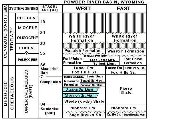
Figure 2. Stratigraphic nomenclature for Late Cretaceous and Tertiary rocks, Powder River Basin (stratprb.gif, 32 KB).
The Cretaceous epicontinental seaway connected the Gulf of Mexico with the Arctic Ocean during deposition of the Upper Cretaceous Cody Shale, as shown on figure 3 (Brenner, 1978, Gill and Cobban, 1973). The western margin of the seaway was marked by a tectonically active thrust belt that extended from Alberta to southern Nevada and included the actively growing Rocky Mountains. The eastern margin of the region was a relatively stable cratonic hinge zone that extended from Minnesota to eastern Kansas (Witzke and others, 1983).
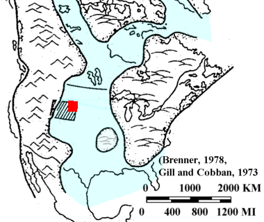
Figure 3. Map showing Cretaceous epicontinental seaway paleogeography during Campanian time (Late Cretaceous) (modified from Brenner, 1978, reprinted by permission, Gill and Cobban, 1973) (wseaways.gif). The large rectangle is Wyoming, the small one shows location of the Powder River Basin.
Late Cretaceous time was marked by episodic transgression and regression of the Cretaceous epicontinental sea (Weimer, 1984), which resulted in deposition of primarily marine sediments in the northern part of the seaway. Kauffman (1977) lists as many as 10 transgressive-regressive cycles for the Western Interior during Cretaceous time. This list includes marine transgression during the time of deposition of the Sussex Sandstone Member, followed by regression of the sea. These cycles are correlative around the world and were based on biostratigraphy and radiometry (Vail and others, 1977).
Distinct eastward changes in shelf, slope, and basin morphology have been mapped in the Powder River Basin by Loutit and others (1988), who believe that a eustatic sea level rise in latest Maastrichtian time, about 67 million years ago (Ma), significantly affected sedimentation patterns on continental margins; this event roughly correlates with the start of the Laramide orogeny (Tweto, 1975, 1980). Lillegraven and Ostresh (1990), however, postulate that Upper Cretaceous time in the seaway is marked by a very slow regional regression of the shoreline that is consistent with global lowering of sea level for this time period; their data are based largely on mapping and analysis of ammonite zones. Their evidence indicates that shoreline position during Late Cretaceous time was relatively static and considerably west of Sussex "B" sandstone deposition.
During Campanian time (74-84 Ma) most of the Powder River Basin was part of a broad muddy shelf. Pierre and Cody Shales deposition is characterized by mainly marine muds punctuated with relatively thin sands (Brenner, 1979). During deposition of the Cody Shale, regional morphology consisted of a distinct shelf, slope, and basin configuration; relief on the shelf may have been about 1,000 ft (300 m) in the eastern part of the Powder River Basin (Asquith, 1970). The abrupt eastern termination of the Sussex Sandstone corresponds with thinning and eventual pinchout of the Sussex interval (Brenner, 1979).
The Upper Cretaceous Sussex "B" sandstone was deposited in a probable mid-shelf position in the Cretaceous epicontinental seaway (Higley, 1994). Basin morphology during deposition of Sussex and Shannon shelf sandstone beds in the Powder River Basin is illustrated on figure 4 (shelfmod.gif) (Tillman and Martinsen, 1984).
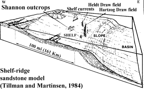
Figure 4. Basin morphology during deposition of shelf sandstone beds in the Powder River Basin (Tillman and Martinsen, 1984 reprinted by permission). The House Creek field is located about 10 miles (16 km) east of and approximately parallel to Hartzog Draw field. Oil in the Hartzog Draw and Heldt Draw fields is produced from the Upper Cretaceous Shannon Sandstone.
Actual proximity of the Sussex "B" sandstone relative to shoreline is unknown. The difficulty with sand-ridge models lies with transporting and reworking sediments this far from shore. This Sussex "B" and other Sussex and Shannon Sandstone mid-shelf sand ridges had the following sources of sand and sediment transport:
- Transgressive erosion of sediments,
- linked with shelf transport and
- storm currents,
- probable existence of lobate deltas of the Upper Cretaceous Eagle Formation to the west (Hobson and others, 1982, Higley,1994).
One source of sand for the Sussex Member and underlying Shannon Member is erosion of precursor marine and possible nonmarine strata during transgression, with redeposition in shoreface to mid-shelf environments as marine-ridge sandstones.
Possible Structural Controls on Deposition of Shelf Sands
Deposition of shelf sands may also result from local and regional tectonic activity in the region. Kauffman (1977) believed the eastern platform of the Powder River Basin showed minimal localized tectonic activity, as reflected in a broad uniform pattern of marine sedimentation. Topographic highs on the Cretaceous shelf could have developed as a result of;
- Recurrent faulting or folding,
- Deposition of thick accumulations of sediment (e.g., deltas),
- Preservation by draping and (or) compaction of paleotopography from unconformities, and
- Erosion and sculpting of sediments during a lowered sea level (Slatt, 1984).
An ordered sand-ridge field, such as the Shannon Sandstone in the Hartzog Draw area (figure 4), located about 10 mi (16 km) west of the House Creek field, develops from an initial, low-relief, highly variable topography (Gaynor and Swift, 1988). Tillman and Martinsen (1984), stated that "Detailed subsurface correlations of the Shannon sand ridges throughout the Powder River Basin, using well-developed bentonite markers, show the reservoir facies to "rise and fall" parallel to their elongation, indicating that the ridges were not deposited in layer-cake fashion." Sandstone ridges in the Sussex "B" sandstone rise to the north and to the west. These stratigraphic patterns of development of the higher energy shelf-ridge facies are interpreted to reflect sea-floor topography during their deposition. If basin structural features resulted in topographic highs during deposition of the Sussex "B" and other offshore sandstones, they could have resulted in concentration of sand and (or) sand ridges on the muddy shelf.
Holocene shelf sand ridges on the Texas shelf and the Georges Bank - Nova Scotia - Newfoundland - Labrador shelf system (Slatt, 1984) were examined and compared to sand-ridge deposits from the Cretaceous epicontinental seaway. Ridges in the transgressive Holocene sand sheets are associated with topographically high banks. Sediments here are derived from reworking of underlying substrates with contemporaneous deposition of mud in adjacent low areas. Oceanic currents play a strong role in localizing sand ridges, in grain sorting efficiency, and in areal distribution and stacking patterns of sands and muds.
Lithostratigraphic and biostratigraphic data suggest Sussex Sandstone depositional intervals east of the House Creek field are compressed rather than missing (Gill and Cobban, 1966; Asquith, 1970; Brenner, 1979). This indicates a reduced sediment accumulation rate east of the field and greater rates of compaction for mudstone than sandstone. This also indicates the area of the House Creek field was a paleo-topographic high. Thickness of the "B" sandstone ranges from several feet along and east of the seaward margins of the field to almost 60 ft (18 m) along the western margin; this is a lateral distance of 1 to 1.5 miles. Sediments along the western field margin consist mainly of moderate- to low-depositional energy sandstone and mudstone. This wedge shape also indicates oceanic currents which sculpted the Sussex "B" sandstone were a fractionation mill. Sediments were eroded from the front of the marine ridges and re-deposited landward (westward). This is illustrated by figure 5. This north-south-oriented vertical slice of the Sussex "B" sandstone is located near the northern boundary of the study area. It was mapped using the basal disconformity surface at the datum; the actual shape of the "B" sandstone is probably wedge-shaped with a lower surface that curves downward to the left (landward). This is an oblique slice across the field, the wedge shape is even more pronounced when cut perpendicular to the field axes.
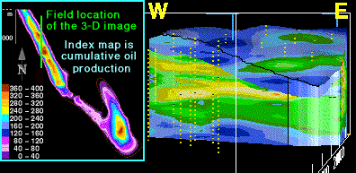
Figure 5. This north-south-oriented vertical slice of the 3-D porosity model (3dns_img.htm) shows upward and westward (landward) increase in sediment thickness, and progressive westward deposition of later sands in the Sussex "B" sandstone (wedgessx.gif). Blue on the 3-D model is primarily mudstone and sandstones containing less than 8 percent porosity, green is mainly fine- to medium-grained sandstones exhibiting 8 to 12 percent porosity, and yellow contours are mainly medium-grained trough-cross-bedded sandstones that contain greater than 12 percent porosity. Respective average porosity of the "B" sandstone and of reservoir intervals are about 8 percent and 12 percent. Slice width and thickness are about 2.5 mi (4 km) and 50 ft (15 m). Vertical exaggeration is 60x. Yellow dots are well sample locations. Index contour map shows cumulative oil production per well; contour interval is 40,000 barrels.
Tectonic influences may have altered sea floor relief and slope of the shelf during deposition of the Sussex "B" sandstone. This would provide sources of sediment through changes in relative sea level and oceanic currents, and influence areas of sediment deposition. Slack (1981) believes the Belle Fourche arch ( fig. 1), and other associated northeast-trending structural lineaments in the northern two-thirds of the Powder River Basin controlled localization of all significant Shannon and Sussex productive sandstones. Sussex and Shannon production is concentrated along the arch in this area of the basin. The axis of the arch crosses the northern quarter of the House Creek field. Location of the arch is based on gravity data; structures are difficult to identify from conventional subsurface structure maps. Uplift and erosion throughout Wyoming prior to deposition of the Teapot Sandstone Member of the Mesaverde Formation (72 Ma) (fig. 2) probably obliterated evidence of additional transgressive and regressive phases of deposition during the latter part of the Late Cretaceous (Gill and Cobban, 1966).
The Belle Fourche arch probably formed from subtle variations in regional structural patterns which are precursors to the Laramide orogeny (Slack, 1981). Subtle uplift along the arch occurred from Lower Cretaceous Muddy through Upper Cretaceous Sussex deposition, a period of about 35 m.y. The Belle Fourche arch was slightly positive during deposition of the Sussex Sandstone (Slack, 1981), and marine ridge deposition over structural highs may have generated topographic highs along the arch.
Other suggestions of greater topographic relief and subtle uplift in the House Creek field area are 1) deposition of the Sussex "B" sandstone began in the southeastern corner of the field and progressed to the north, toward the arch, 2) the thickest section of the Sussex "B" sandstone, and many intervals of Shannon Sandstone, are located near the axis of the arch, 3) in fact, most of the productive Sussex and Shannon intervals are along this trend, and 4) the thin, areally discontinuous Sussex "A" sandstone overlies the "B" sandstone along the western field boundary. The "A" sandstone, located just below the Ardmore bentonite, produces oil from the Triangle U field. This field is located on the axis of the Belle Fourche arch in T. 46 N., R. 75 W.