PETROLEUM GEOLOGY OF THE SUSSEX "B" SANDSTONE
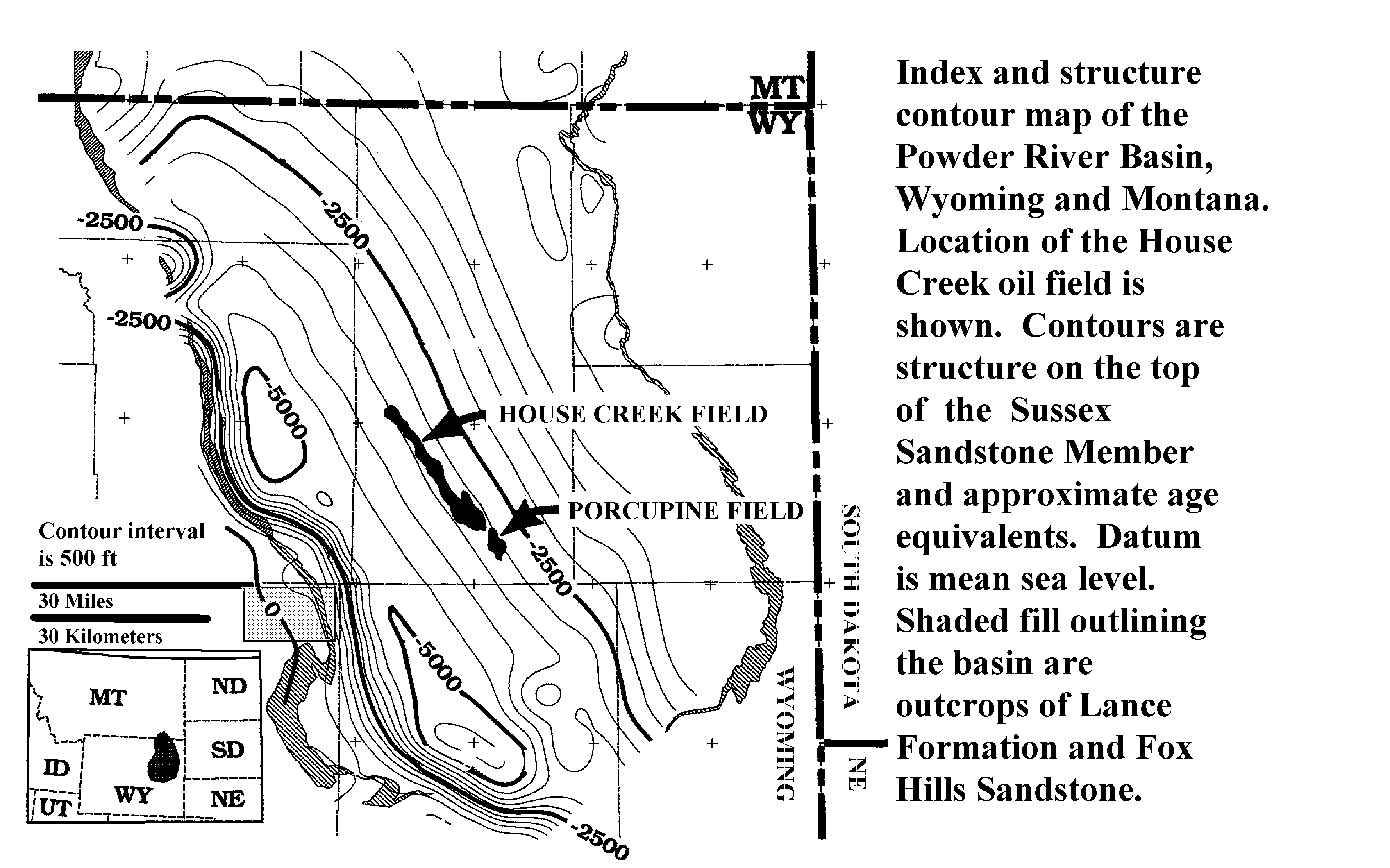
The Powder River Basin is an asymmetric Laramide-age structural basin with a steeply dipping western flank and a gently dipping eastern flank. The Upper Cretaceous Cody Shale, including the Sussex Sandstone Member and its equivalents, underlies most of the Powder River Basin and outcrops along the western flank, west of the Lance Formation and Fox Hills Sandstone outcrops shown as stippled patterns on figure 1 (indexfsm.gif).
The areal extent of the Sussex "B" sandstone is also indicated on figure 1; the eastern boundaries of the House Creek and Porcupine fields approximate the eastern limit of the "B" sandstone. While the western margin of the fields does not define the western limit of the "B" sandstone, it does show the limit of reservoir-grade facies. There is a probable upper sandstone of the "B" located along the northwestern margin of the House Creek field, although well data is insufficient to determine whether reservoir-grade facies are present. Sussex "B" sandstone facies west of the field margins are mainly low-porosity and low-permeability mudstones and interbedded thin sandstones.
Figure 1. Structure contour map on the top of the Upper Cretaceous Sussex Sandstone Member of the Cody Shale and approximate age equivalents, Powder River Basin, Wyoming and Montana. Location of the House Creek field is shown. Areal extent of the Sussex "B" sandstones is delineated by black-colored fields. Shaded fill outlining the basin are outcrops of Lance Formation and Fox Hills Sandstone. The rectangle located to the right of 30-miles scale bar defines the area of studied outcrops of the Sussex and Shannon Members, much of the Salt Creek anticline, and the towns of Midwest and Edgerton. Contour interval is 500 ft. Datum is mean sea level. A detailed (176 KB) version is named indexfig.gif.
Most oil production in the Sussex "B" sandstone is from the House Creek field with only minor production from the Porcupine field. More than 24.8 million barrels of oil (MMBO), 21.2 million cubic feet of gas (MMCFG) and 1.6 MM barrels of water have been produced from the Sussex "B" sandstone in the House Creek field (PI Production data through December, 1996). Concentrated along field axes are greatest oil production, and the most porous, permeable, laterally continuous, and thickest sandstone beds; combination of these factors indicates the Sussex "B" sandstone and similar reservoirs would be good candidates for horizontal drilling. The figure 32 (oilprod.gif) contour map of cumulative oil production across the field area shows concentration of greatest production along the southeastern and northwestern ridge systems. Estimated original oil in place (OOIP) was 159 million barrels (Sabel, 1985). Ultimate recovery is estimated at about 45 MMBO and 40 MMCFG, less than 30 percent of the OOIP. The Porcupine field is located at the southern margin of the House Creek field. More than 3 MMBO and 5 MMCFG have been produced from all reservoirs within the Porcupine field; production is commingled for the Sussex "B" sandstone, the Muddy Sandstone Member of the Early Cretaceous Thermopolis Shale, and the Turner Sandy Member of the Upper Cretaceous Carlile Shale (Lawyer and others, 1981).
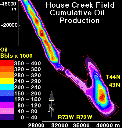
Figure 32. Contour map of cumulative oil production across the House Creek field area. Field is delineated by the red line. Contour interval is 40,000 barrels of oil. Map scale, in meters, is shown around the margin. Township and range line intersections are also drawn. Greatest production is proximal to field axes; these are also areas of stacked sand ridges; oil is commonly produced from 2 sandstone bodies separated by a permeability barrier. Porosity and permeability generally decrease west of the eastern margins of the field, so increase in production along the field axes is a function of thickest intervals of stacked sandstones with greatest porosity and permeability.
The House Creek field has two axis orientations; these result from depositional patterns of the four sand ridges. Deposition of the "B" sandstone began in the southeastern corner of the field with sand ridge 1; axis orientation of this sand ridge is about north 20 degrees west. Overlying and later deposited sand ridges 2 through 4 are located west and north of sand ridge 1; their axis orientations are approximately north 32 degrees west. Progressive northward deposition of later sand ridges is probably associated with contemporaneous uplift of the northeast-trending Belle Fourche arch, which cuts across the northern boundary of the field in figure 1. The arch orientation is perpendicular to the field. Movement along the arch and lineaments may have caused topographic highs that localized Sussex and Shannon deposition along the arch (Higley, 1994).
Reservoir intervals exhibit upward and seaward increases in grain size, porosity, and permeability, both across sand ridges 1-4, and for the individual stacked thin-bedded reservoir sandstones that comprise the sand ridges. Individual thin trough-cross-bedded sandstones commonly coarsen downward. Greatest oil production, porosity, permeability, thickest reservoir sandstone intervals, and best lateral continuity of the primary reservoir facies are all located parallel and proximal to field axes.
Oil is stratigraphically trapped in the Sussex "B" sandstone by an updip and overlying change from porous and permeable sandstone to relatively impermeable mudstone, and by an areally discontinuous capping chert-pebble sandstone; there is no oil-water contact in the field. Rapid decline in porosity and permeability at the upper contact of the Sussex "B" sandstone is visible on well log traces, core and core data, and vertical slices of 3-D porosity and permeability. Sussex "B" facies west and east of the field boundaries are non-oil-productive, low porosity and permeability sandstones and bioturbated mudstones. These are the low-depositional-energy facies. "Correlation of electric logs across the fields (in the area) shows that a thick section of relatively low-permeability sandstone or siltstone is present in dry holes down dip from the (House Creek) field on the southwest" (Berg, 1975).
Primary, secondary, and tertiary recovery of oil is strongly affected by reservoir heterogeneities. House Creek field heterogeneity includes concentration parallel and proximal to field axes of greatest oil production, porosity, permeability, and greatest thickness and stacking of reservoir sandstones. Production is adversely affected by complex interbedding of thin-bedded reservoir sandstones with low-permeability sandstones and mudstones. These numerous permeability barriers and baffles cause field- and well-scale compartmentalization. Production is also decreased by pore-filling kaolinite and ferroan-calcite cements. Thickness of the permeability barriers that separate and compartmentalize upper from lower sand ridges is variable across the field. These low-energy facies were sometimes removed by erosion prior to or during deposition of overlying sandstones. This is particularly common in the northwestern half of the field area.
The following two figures are plan-view contour maps of the entire thickness of Sussex "B" sandstone in the House Creek field (figure 6, ssxisos.gif), and of the reservoir sandstone interval (figure 33, resisos.gif).
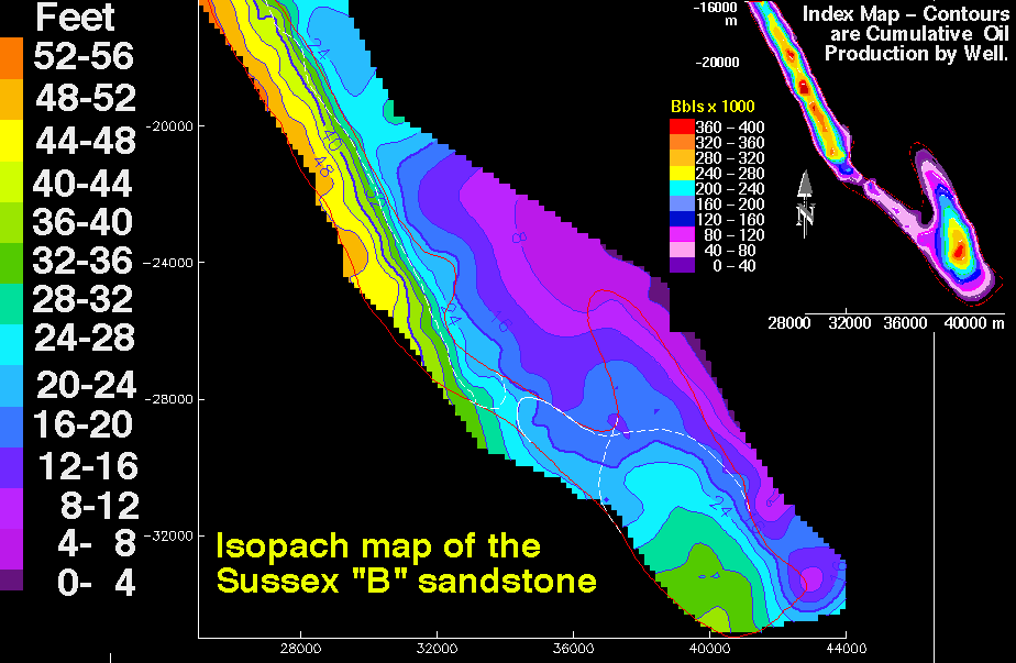
Figure 6. Isopach map of the Sussex "B" sandstone showing thickness in feet of the interval between bounding disconformities; contour interval is 4 ft (1.2 m). Map scales are meters. The small index contour map is cumulative oil production; contour interval is 40,000 barrels. The thin red line outlines the boundary of the House Creek field. Thin white lines in the southern half of the field are limits of sand ridge 1 and overlying sand ridge 2. The large-scale 64 KB image is named ssxiso.gif .
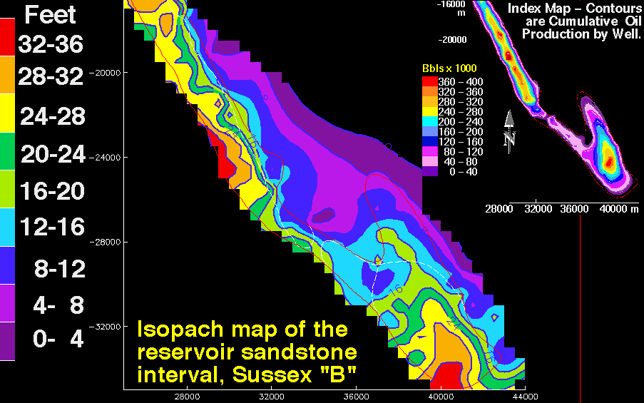
Figure 33. Sussex "B" sandstone isopach showing thickness in feet of the reservoir-grade sandstone interval. The House Creek field is delineated by red lines; the faint white lines outline sand ridge boundaries. Contour interval is 4 ft (1.2 m). Map scales are meters. In some areas, contours are extrapolated outside of data control. Reservoir sandstone intervals were determined by examining well-log traces of about 120 wells, as well as core and petroleum production data; boundaries correspond to a cut-off of about 8.5 percent porosity. This interval includes lower porosity sandstone and mudstone located within and between sand ridges. Index map is cumulative oil production across the field; contour interval is 40,000 barrels of oil (BO) for the range 0 to 400,000 BO. Resiso.gif is the large-scale 64 KB contour map of reservoir intervals.
Illustrated by the figures 6 and 33 contour maps are:
The House Creek field was discovered by Woods Petroleum in 1968 (Berg, 1975; Sabel, 1985). Low initial production of 90 barrels of oil per day (BOPD) for the No. 1 State 1319 discovery well resulted in low rates of early drilling for the field. The well is located in sec. 36, T. 44 N., R. 73 W. within the "shadow zone" of low-depositional-energy facies that lies between the northwestern and southeastern ridge systems. The well is situated between sand ridges 2 and 3 on the following plan-view image of the top of the Sussex "B" sandstone (figure 34, ewhslics.gif).
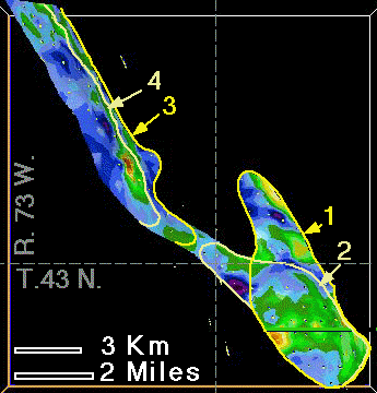
Figure 34. Plan-view map on the upper disconformity surface of the Sussex "B" sandstone within the House Creek field. Reservoir-grade intervals are shown by green through red (8 to 21 percent porosity); low-porosity non-reservoir intervals are purple through blue (1 to 8 percent porosity). Sand ridges 1 through 4 and field boundaries are delineated by yellow and tan; dashed lines separate townships and ranges. Basal sand ridges are 1 and 3.
The following House Creek field production decline curve (figure 35, declines.gif), for the period from January 1976 through August 1992, shows gradual decrease in barrels of oil recovered, mirrored by increasing gas production and associated increase in gas-oil ratio (GOR). GOR on the chart is multiplied by 100,000 to better show the curve. Increases in gas production are primarily due to decrease in reservoir pressure as oil is pumped out. Original GOR was 341 and initial field pressure was 3,220 psi (Bauder, 1981). Pronounced dips in the curves result mainly from periods of non-production due to maintenance and (or) economics.
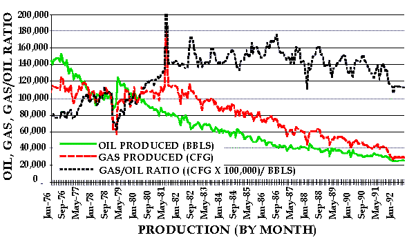
Figure 35. Production decline curve for monthly intervals from 1976 through August 1992 in the House Creek field. Oil (BBL), gas (CFG) and gas/oil ratio (GOR) curves are shown. GOR is multiplied by 100,000 to better view increase in through time of gas production relative to oil. Water production is not shown due to small volumes. Cumulative production to January 1976 was 8.73 MMB of oil and 4.06 MMCF of gas (Petroleum Information Corp. production data).
Average cumulative oil production per well for 111 wells (through July 1993) in the House Creek field is 120,000 barrels; average cumulative gas production is 110,000 cubic feet. Initial production averaged 154 barrels of oil per day (BOPD) for 108 wells within the field boundaries. Average perforated thickness is 14 ft (4.3 m). Most wells perforate both upper and lower sand ridges, and production is commingled (not separated out by upper or lower sandstones). The thickest perforated intervals are located in wells near the southwestern tip of the field, and along and west of the field axis in the northwestern half of the field.
A combination of liquid expansion and solution was the original drive mechanism of the House Creek reservoir; pump production was necessary from the 1968 discovery date (Sabel, 1985). Completion practices consist primarily of casing, perforating, hydraulic fracturing, and, in some instances, acid treatment to increase productivity. "A secondary recovery waterflood, scheduled to start in early 1986, is expected to increase production from 12.5 to 21.5 percent of the original oil in place" (Sabel, 1985). Production to 1995 is 14 percent of original oil in place (OOIP).
Woods Petroleum operated a secondary recovery unit from section 12 of T. 45 N. to the southern boundary of the field, and Inexco Oil operated the recovery unit for the rest of the field. A 3-to-1 line drive flood was originally planned in order to minimize additional drilling. Woods predicted secondary recovery of 83 percent of primary recovery; testing of residual oil in core samples indicates residual oil content of 40 percent in water-swept areas (Sabel, 1985).
The southern half of the House Creek field is owned and operated by Kerr-McGee Corp. of Oklahoma, which took over the property from Sonat Exploration Co. in 1991 (Lyle, 1992). Kerr-McGee adjusted Sonat's 3-to-1 line drive water-flood program to a 1-to-1 pattern to increase recovery of oil. The 1-to-1 pattern has one row of producers for one row of injectors (Lyle, 1992). Increase in production will result from minimizing bypass of oil that would have occurred using the 3-to-1 pattern because of a more even sweep of injected fluids parallel to field axes. Primary flow unit orientation for the most porous and permeable sandstones is parallel to field axes (Higley, 1994). Kerr-McGee will convert 28 wells from producers to injectors (Lyle, 1992). With the new pattern, Kerr-McGee is planning about 15 new wells, including 4 injector wells, for a total of 130 (Lyle, 1992).
The project is currently a polymer flood and qualifies for tertiary recovery status. Potassium hydroxide (KOH) is added to injected water to decrease swelling of clays and resulting loss of injected water through high-permeability stringers. Clays are primarily kaolinite (0.8 percent based on thin-section analysis) with trace amounts of illite, illite-smectite, and ferroan chlorite (chamosite) minerals. Quartz overgrowths isolate most chlorite from injected fluids. KOH removes oil near well bores thereby increasing formation permeability to injected water (Lyle, 1992).
The following thin-section photomicrograph (figure 36, oilstnsm.gif) is an oil-productive, medium-grained trough-cross-bedded sandstone. Oil (dark brown) coats grains and fills voids. The large pore in the upper left quarter of the image is mainly secondary, resulting from dissolution of a (now-absent) probable feldspar (F) grain. This late-stage dissolution resulted in precipitation of kaolinite (K); associated microporosity causes decrease in permeability. The feldspar grain located below the labeled kaolinite exhibits intragranular porosity resulting from grain erosion; this enhances oil emplacement by creating secondary pore spaces. Other grains exhibit peripheral dissolution; this primarily improves permeability by improving interconnections between pores. Kaolinite resulted mainly from late-diagenetic migration of organic acids into the Sussex "B" sandstone and other chemical changes associated with oil generation and migration (Higley, 1994). The large pores are void of oil because it drained out during coring and thin-section preparation.
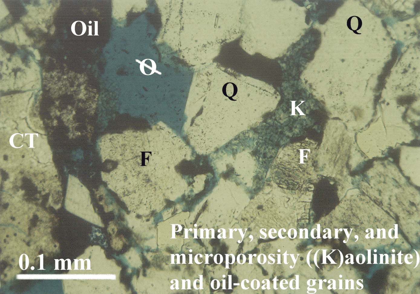
Figure 36. Transmitted-light thin-section photomicrograph of an oil-productive trough-cross-bedded, medium-grained sandstone from the House Creek field. Oil (brown) coats primary and secondary pore spaces. Spotty distribution of oil in the kaolinite (K) results from low permeability and microporosity. Feldspar (F) grain is partially dissolved. Quartz (Q) and chert (CT) grains are labeled. Blue epoxy fills pore spaces (ellipse with a line through it). The full-size photomicrograph is oilstn.gif, 1.4 MB .