Heterogeneity (essentially nonuniformity) in sandstone reservoirs is controlled by the following factors; (modified from Weber, 1986; Schenk, 1988, 1992):
Reservoir quality in the Sussex "B" sandstone is a function of sedimentologic and petrologic heterogeneity. This and the following section discuss the relative influences of the above factors on porosity and permeability distribution and development. Faulting, aside from minor fracturing as viewed in core, is undocumented for the Sussex "B" sandstone.
Initial porosity in the Sussex "B" sandstone in the basin was probably 35-40 percent by volume for trough- and planar-cross-bedded facies. Because of poor sorting (more clay and mud) finer grained sandstones exhibit lower initial porosity and permeability. The porosity range is based on examination of 54 thin sections and is tied to analogs. Pryor (1973) analyzed distribution of porosity and permeability in unconsolidated beach sands in the Gulf Coast; he found that initial porosity of 39 to 56 percent decreased rapidly with burial. Wilson and Sibley (1978) determined that the Cambrian Galesville Sandstone, of Wisconsin, exhibited initial porosity of 45 to 50 percent; this decreased during burial to about 33 percent. This decrease resulted mainly from rearrangement of grains during early burial. Further reduction to 24 to 33 percent was due to later quartz pressure solution (dissolution of quartz grains and associated closer packing of grains), and emplacement in pores of dissolved quartz, kaolinite (clay), iron hydroxide, and adularia (a feldspar mineral).
Sussex "B" sandstone porosity and permeability range up to about 21 volume percent and 200 millidarcies (mD), respectively, for core tests from 15 widely scattered boreholes. Geometric mean of permeability for this 791 core-plug data set is 0.62 mD.
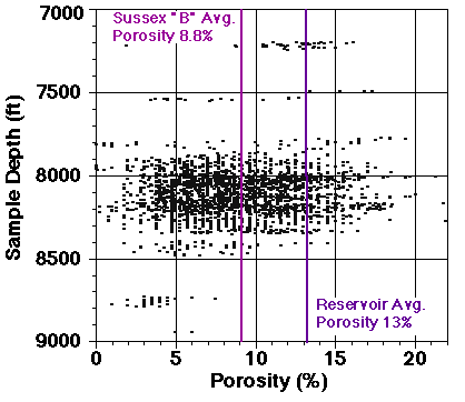
Core plus well-log average porosity is 8.8 percent for the entire interval of the Sussex "B" sandstone, and about 13 percent for reservoir intervals. These 2,600 core plus well-log points have median porosity of 8.4 percent. Porosity values were calculated from bulk density well-log traces for approximately 100 wells; values were recalibrated to a specific grain density of 2.68 g/cm3 (Higley, 1994). Sonic log traces were used for porosity calculations for several wells. These porosity/permeability data files are located in the data_set directory.
Figure 15. Graph of core and well-log porosity versus depth for 2,600 Sussex Sandstone Member points. The average 8.8 percent porosity of the Sussex "B" sandstone and of reservoir intervals (13 percent) is also plotted. Scatter in data is considerable.
Published reports of reservoir permeability and porosity in the House Creek field vary; Bauder (1981) listed a geometric average permeability of 6.9 mD for the Sussex "B" sandstone. Sabel (1985) reported mean porosity and permeability of 13 percent and 15 mD, respectively, for reservoir sandstones in the House Creek field.
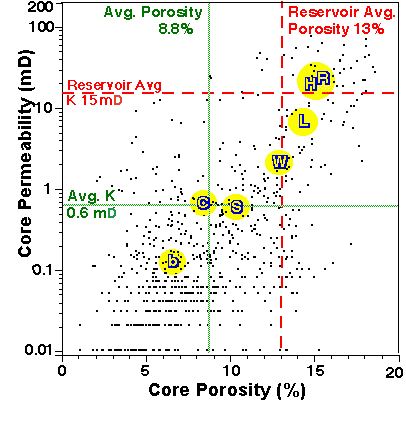
Figure 16. Volume percent porosity and permeability for 791 core plug samples for 30 wells, Sussex Sandstone Member (Higley, 1994). Greater porosity correlates with permeability increase. Scatter in data is considerable. Dotted green lines are geometric averages for this data of 8.8 percent porosity and 0.62 mD permeability. Dashed red lines represent average porosity and permeability of 13 percent and 15 mD for reservoir intervals of the "B" sandstone. Yellow circles surround average porosity and permeability values for sand-ridge facies determined from core examination of 8 wells. Sandstone facies are: chert-pebble lag, C; central-ridge, R; high-energy ridge-margin, H; low-energy ridge-margin, L; wavy-bedded, W; inter-ridge sandstone, S; and burrowed inter-ridge sandstone and mudstone, b.
Sussex "B" sandstone facies and mineralogy vary greatly at megascopic (field scale), and even more so at macroscopic (well and rock), and microscopic (thin-section) scales. The most porous, permeable strata are the moderate- to high-depositional energy trough-cross-bedded medium-grained sandstones; these are primarily concentrated towards the tops of sand ridges. Increase in porosity and permeability is tied to increase in depositional energy. This results from:
Amounts of calcite cements in 17 trough-cross-bedded (H, R, and L in the above porosity/permeability figure) sandstone samples range from 2.3 to 34 percent, and average 8.8 percent. Conversely, 7 samples of inter-ridge burrowed mudstone to fine-grained sandstone (b, S, W) only averaged 4.2 percent calcite cement. Resulting average minus-cement porosity is calculated at only 18 percent. Extensive loss of porosity and permeability due to compaction and prior to calcite cementation, is indicated by the low percentage of calcite cement and large volume of mudstone and other soft sediments (about 27 percent).
Percent volumes of calcite cement and intergranular porosity for 54 thin sections are shown on figure 17; microporosity within clays and grains is not recorded. Thirteen percent porosity is average for reservoir intervals; 8.8 percent is average for the entire Sussex "B" sandstone, based on core porosity/permeability of 791 points. Intervals of greatest porosity generally contain less than 3 percent calcite cement; calcite cement in this mainly trough-cross-bedded-sandstone facies is commonly spotty in thin sections, with evidence of extensive dissolution of cements.
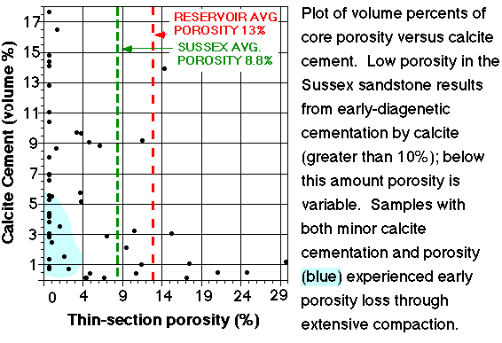
Figure 17. Plot showing volume percentages of core porosity and calcite cement for the Sussex "B" sandstone. Low-porosity sandstones associated with greater than 10 percent calcite cement commonly contain no effective porosity. This occurs mainly during the earliest stage of calcite cementation. The region with low porosity and minimal calcite cementation results from early diagenetic compaction. These samples are primarily burrowed and bioturbated sandstone and mudstone.
Flow units are reservoir zones that exhibit similar fluid flow, porosity/permeability, reservoir potential, and production characteristics. Ebanks (1987) defined flow units as "volume of rock subdivided according to geological and petrophysical properties that influence the flow of fluids through it." Flow unit characteristics of the various Sussex "B" sandstone facies are assigned and detailed in Higley (1994); they are included below to show porosity/permeability/facies types for each reservoir and non-reservoir group of rock types.
Sussex "B" sandstone fluid flow potential is rated E(xcellent), G(ood), F(air), and P(oor). These categories are general indicators of the reservoir favorability. Divisions are based on porosity and permeability characteristics of central ridge and other facies, probable directions of maximum fluid flow in the field, vertical and lateral continuity of reservoir and non-reservoir flow units (based on core, outcrop, and geophysical well-log examination), presence and number of permeability barriers and baffles, and petroleum production characteristics of wells. Table 3 lists six flow units; these consist of three reservoir (E, G, F) and three low-permeability, non-reservoir (P5, P6, P7) units. Flow unit E exhibits excellent reservoir and fluid flow properties; G contains good reservoir properties, F exhibits marginal to fair reservoir properties, and the non-reservoir P units (P5, P6, P7) are permeability baffles and barriers bounding and interbedded with E, G, and F flow units. Determination of thickness and distribution of flow units across the field was based on examination of core from 20 wells, well-log data for more than 120 bore holes, and on outcrop studies.
FLOW-UNIT RATING, PERMEABILITY (mD), POROSITY (PERCENT), AND PETROLOGIC CHARACTERISTICS
E, >15 mD, 10 to 22 percent,
G, 12 to 40 mD, 8 to 18 percent,
F, 5 to 20 mD, 8 to 18 percent,
P5, .01 to 2 mD, 1 to 13 percent,
P6, .01 to 15 mD, 1 to 16 percent,
P7, .01 to 19 mD, 1 to 16 percent,
An example of a Good to Excellent flow unit is the trough-cross-bedded medium-grained sandstone shown in figure 18 (bedding planes are outlined in blue and purple in this snncrp1s.gif image). This is a non-productive probable lower-shoreface (near the beach) sandstone of the Shannon Sandstone Member. Even though this is a very porous sandstone, porosity, permeability, and fluid flow are all decreased by the thin sandstone beds (bounded by purple) that are highly cemented by quartz. Flow is influenced by orientations of trough-cross-bedding planes. Primary direction of maximum fluid flow is perpendicular to this image, and along the bedding planes of the individual cross-bedding laminae. Note also (for future reference) that individual beds have general lensate and tabular forms. The thin, highly cemented, low-permeability sandstone layers are massive in appearance, compared to the porous cross-bedded intervals that erode more readily.
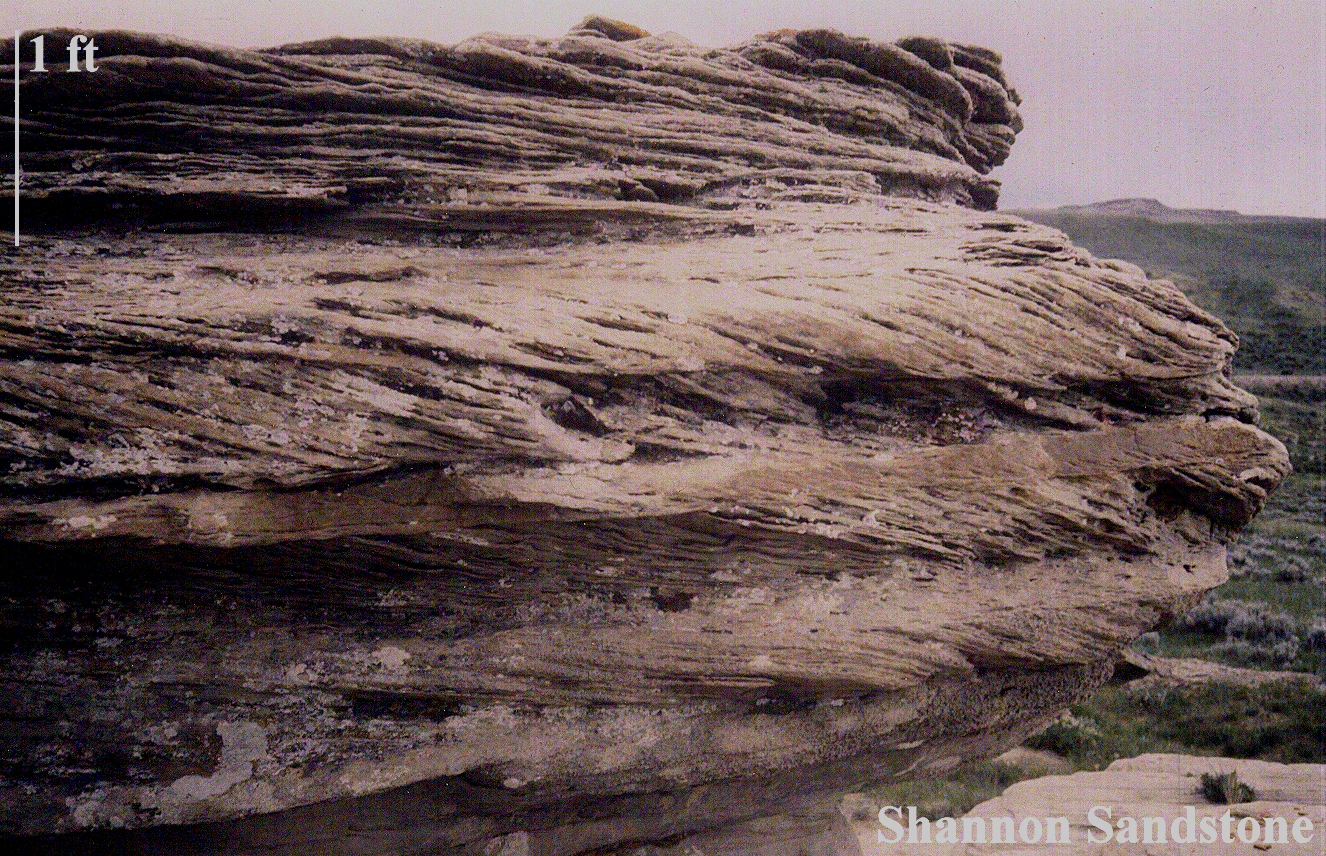
Figure 18. This outcrop of a Shannon Sandstone Member trough-cross-bedded sandstone is located at Shepperson Ranch, west of Midwest and Edgerton, Wyoming (figure 1). The thin, low-porosity, quartz-cemented beds are outlined in purple in this small-scale view. Porous and permeable intervals are bounded by a blue line. The 1.2 MB image is named snncrp1.gif .
Sussex "B" sandstone heterogeneity in the House Creek field results mainly from the following factors. Many of these factors are discussed in other sections, for example, the interbedding characteristics at macroscopic scales are detailed in the Depositional Model section.
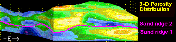
Figure 19. Illustrated are the lensate form of the reservoir, and of individual reservoir sandstones, in this vertical east-west slice showing 3-D distribution of porosity across sand ridge 1 and overlying sand ridge 2. Yellow dots are locations of well-log porosity measurements. Blue and purple areas are primarily non-reservoir intervals. These are basal and landward low-depositional-energy sandstones and mudstones of individual sand ridges (porosity ranges up to 8 percent). Green areas are reservoir-grade porosity of 8 to 12 percent. The breakover point between green and yellow is 12 percent; this approximates the 13 percent average porosity of reservoir intervals; yellow through red (20 percent porosity) are the best quality reservoir intervals. These are largely the medium-grained trough-cross-bedded sandstones, although even here there is considerable interbedding of low- through high-depositional-energy facies. Width of the reservoir at this slice is about 2 mi (4 km). Vertical exaggeration is 60x. This is 3dewlens.gif, slice 10 of the 3-D distribution of porosity model, as shown in the ewporosv.MOV movie.
The reservoir sandstone intervals (green, yellow, orange, and red) are essentially lens shaped. These are composed of many thin, laterally discontinuous, interbedded sandstone and mudstone beds. The sandstone intervals pinch out along the eastern (seaward) margin and grade into non-reservoir (blue) and lower quality reservoir facies along the western field boundary. Datum is the basal disconformity (erosional surface). Using the overlying Ardmore bentonite as the datum, the field actually has a wedge shaped base and top. The same bulge (lens) is visible along the field axis, and reservoir intervals pinch-out to the east. A thin interval of high porosity (red) capping the field in some images is a remnant of the gridding process; a thin, areally discontinuous porous zone is located in several geophysical well logs at the top of the "B" sandstone.
This 3-D distribution of porosity slice (figure 19) reveals;
Core porosity represents point sources, whereas well-log porosity is commonly smoothed over intervals of a few feet. Illustrating the high variability in porosity and permeability over short horizontal and vertical distances requires 3-D images of core data, rather than porosity and permeability calculated from geophysical well logs (data sources and analytical procedures are detailed in the Technical information on data sources section of the Table of Contents).
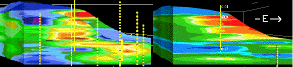
Figure 20. East-west oriented vertical slices of porosity (left, percent) and permeability (right, mD). This image (porpermv.gif) shows the highly variable porosity (left) and permeability (right) using core data. Porosity values/colors are reservoir grade (green through red) of 8 through 21 percent, and below-reservoir-grade low-porosity (blue) of less than 8 percent. Permeability ranges are: purple and blue, up to 5 mD; green, 5 to 16 mD; and yellow through red are greater than 16 mD. Average permeability of Sussex "B" reservoir sandstones is 15 mD. The close-spaced 3-D grid essentially treats each well as a separate set of points for the purpose of showing the variation in porosity and permeability. The various diamond shapes and streaks of low through high porosity and permeability illustrate the interbedding of thin beds of reservoir- and non-reservoir-grade sandstone and mudstone. These diagrams include the eastward and upward increases in porosity and permeability, and stacking of sand ridges shown in previous images. This slice is located in the northwestern half of the field. Yellow dots are (left) core and well-log and (right) core sample locations. Slices are 1.8 mi (2.8 km) wide and 50 ft (15 m) high. Vertical exaggeration is 30x. Respective names of the east-west porosity and permeability slide-image files are 3dew_img.htm and 3dvk_img.htm .
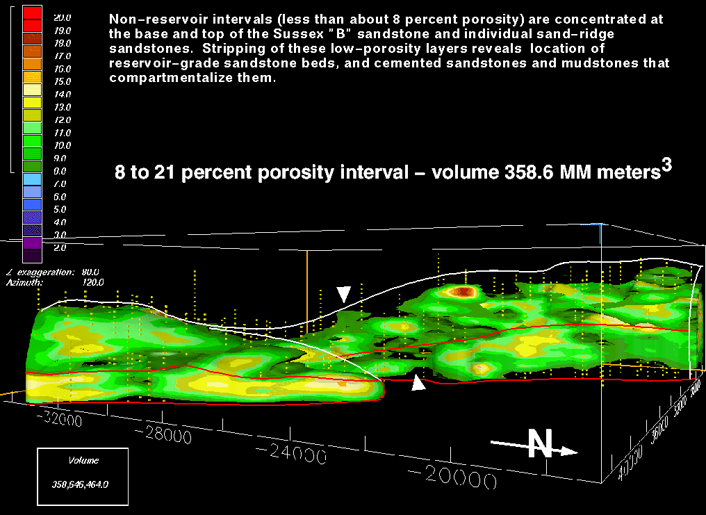
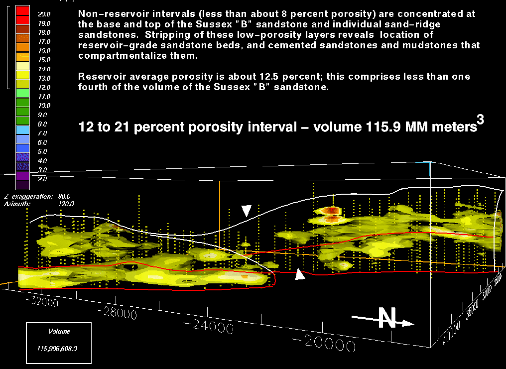
Variable distribution of porous zones is illustrated in figure 21 A. and B. Shown are the respective 3-D distribution and volumes of porosity for 8 to 21 percent, and 12 to 21 percent porosity. These views were chosen along the eastern margin of the field because deposition of the Sussex "B" sandstone began here, and upward and landward (westward) backstepping of later-deposited sand ridges is better displayed with this view than for other orientations. Average porosity of the Sussex "B" sandstone is about 8.8 percent; average porosity of reservoir intervals is about 13 percent. 3-D distribution of intervals of porosity are explained and illustrated in the text (volporf.mov) sections of the table of contents.
A. 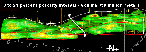
B. 
Figure 21. A. This (por8vol.gif) 3-D view of 8 to 21 percent porosity exhibits a total volume of 358.6 million cubic meters. This is about 70 percent of the total volume of 525.5 million cubic meters of the Sussex "B" sandstone within the field boundaries. The 64 KB full-size image is named eside10f.gif . B. This (por12vol.gif) 3-D image of 12 to 21 percent porosity has a total volume of 115.9 million cubic meters, which comprises less than 25 percent of the total volume of the "B" sandstone in the field. In comparison, the 13 to 21 percent porosity range is about 62.2 million cubic meters; this is about 12 percent of the field volume. The 64 KB full-size image is named eside10j.gif . Green on the figures is 8 to 12 percent porosity. Yellow through red are 12 to 21 percent porosity. Blue arrow marks the boundary between sand ridge 1 and 2. The thin white line marks the upper disconformity surface of the "B" sandstone, except for the seaward margin of the House Creek field, which is outlined in red. The white arrows and line separate the northwestern and southeastern ridge systems; the gap in reservoir-grade porosity units is apparent. X and Y scales are shown in meters around the base of the block. Maximum thickness of the "B" sandstone is about 60 ft (18 m). North arrow is included. Vertical exaggeration is 80x.
Macroscopic and Microscopic (Well and Sample) Scales
Processes of porosity and permeability destruction from pervasive early cementation by calcite and (or) quartz, precipitation of clays, or by compaction are shown in figure 22 (cmts4sm.gif).
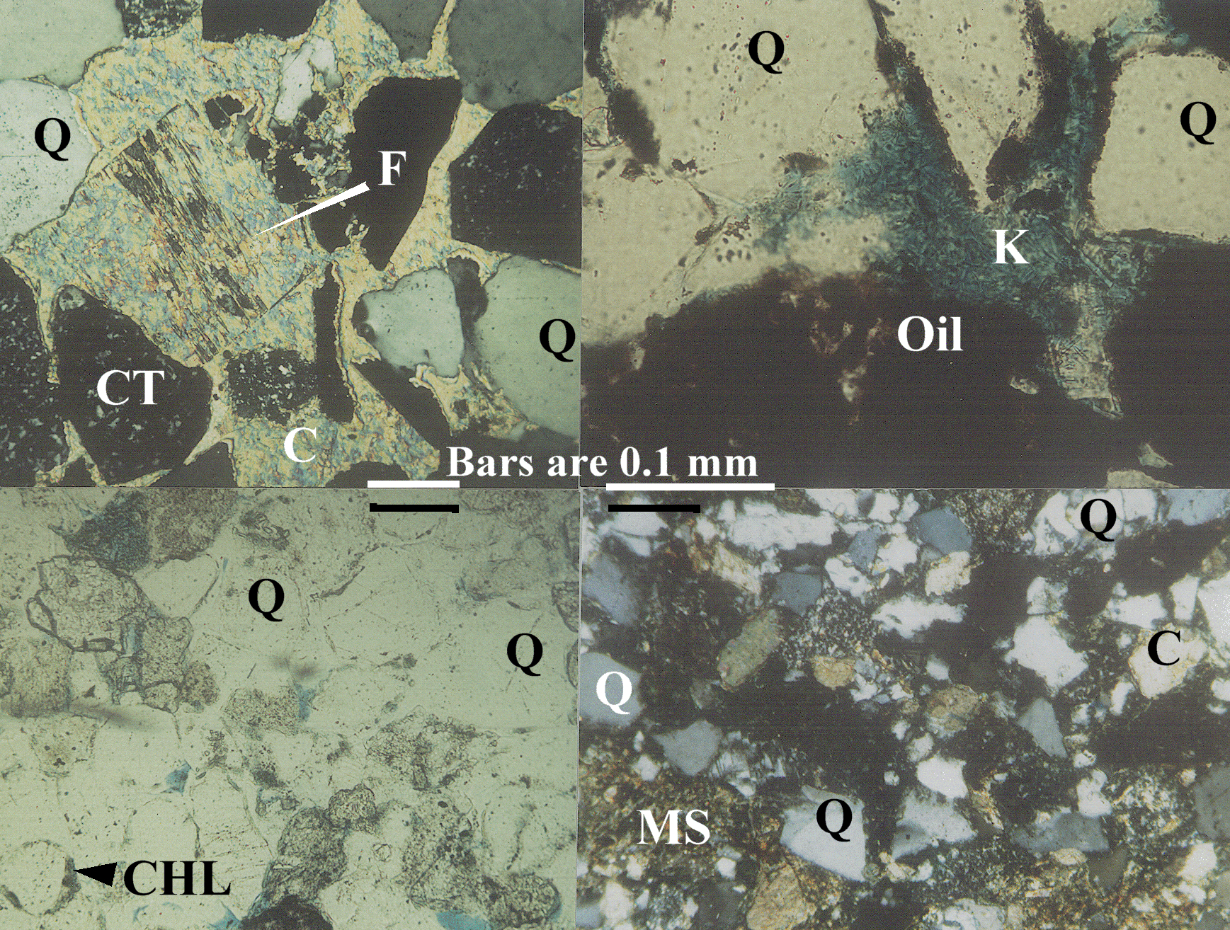
Figure 22. Thin-section photomicrographs of four samples of the Sussex "B" sandstone. Q is quartz, CT shows the chert grains, K is kaolinite, C is calcite, F shows feldspar grain (gray in the crossed-nicols view), MS are mudstone pore-fill and clasts, Oil coats grains and fills pores. Blue epoxy fills pore spaces. cmts4.gif is the full large-scale 2.4 MB image. Clockwise from upper left, images show;
The 3-D computer model images, including figures 21 and 22, show reservoir heterogeneity at megascopic (field) and macroscopic (well and rock) scales. Macroscopic heterogeneity includes stacking of sand ridges, lateral and vertical variation in porosity and permeability, upward and seaward increase in these properties, the lensate and tabular shapes of sandstone beds, and interbedding of high- and low-depositional energy facies. Microscopic heterogeneity, as shown by thin-section and SEM photomicrographs, results mainly from highly variable amounts and distributions of cements and authigenic and detrital clays; this porosity and permeability signature is highly facies related.
Porosity in the Sussex "B" sandstone is mainly primary intergranular (pore volumes remaining from the time of deposition; intergranular means located between the grains). Secondary porosity results from corroded and dissolved feldspar and other lithic grains, which enhances porosity and permeability. Microporosity is present within pore-filling clays, largely kaolinite, and within some corroded chert and other grains. Microporosity is not effective porosity because the small pores are poorly connected. Intergranular plus intragranular porosity in thin sections is as much as 17.5 percent. Average porosity for all thin sections is 5.2 percent; 3.4 percent of this is primary intergranular and as much as 1.9 percent is secondary and intragranular porosity. Average thin-section porosity values for Sussex "B" facies are listed in table 2; this is also located in the ssx_txt directory as the Ssxtable2.txt file. Format is tab-delimited, file is saved as an Microsoft Word text document. Tables located within the HTML documents are ASCII file formats.
Thin-section porosity values are lower than core and average reservoir porosity for two main reasons. First, microporosity is not included in thin-section estimates but is measured during core analysis. The amount of microporosity may be considerable since clays comprise an average 12 percent by volume of the Sussex "B;" clays are the primary permeability barrier at a microscopic scale. The percentage of microporosity should decrease up-section because the amounts of suspended-load sediment and most authigenic and detrital clays decreases upward. Second, three-dimensional effects of thin sections influence point-count results. These 3-D effects include Sussex "B" grain-size sorting and distribution (which are rarely homogenous in sandstones), presence of horizontal laminae and drapes of glauconite and mudstone, orientation of grains and clasts, and other factors that influence heterogeneity.
Sussex "B" sandstone primary and secondary porosity, and microporosity are shown on the following thin-section photomicrograph and SEM images. Pore spaces in all photomicrographs are filled with blue epoxy. Ferroan carbonates are stained blue (ferroan dolomite has dark blue crystals). Unless otherwise indicated, photomicrographs are with transmitted light. Scale bars on most images are 0.1 mm. Porosity in the thin section is partially decreased by early diagenetic cementation of quartz grains. The original rounded quartz grains are outlined by green-colored chlorite crystals. Early diagenetic cementation preserves porosity and permeability in the Sussex "B" sandstone by supporting the grain framework and decreasing porosity loss through compaction.
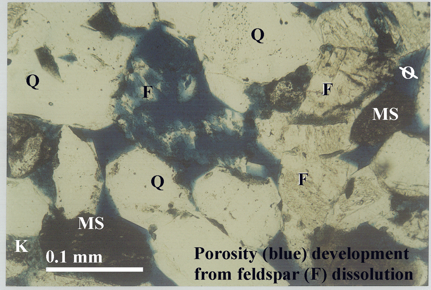

Figure 23. A. Thin-section photomicrograph from 8,012 ft (2,442 m) depth, No. 1 Empire Federal "C" well (fdissols.gif). Dissolution of the large feldspar (F) grain, located near the center of the image, results in secondary porosity. The crystal structure and outline of the feldspar grain is still apparent. Primary (depositional) porosity borders this and other grains. Quartz grains are labeled Q. Microporosity results primarily from breakdown of feldspar into kaolinite (K on large-scale view) and other clay minerals; this causes a mottled appearance of the blue epoxy that fills pore spaces. MS is a mudstone clast. Scale bar is 0.1 mm. The full-scale 1.5 MB thin-section photomicrograph of feldspar dissolution is fdissol.gif. B. Scanning electron microscope (SEM) image of kaolinite shows partings between booklets and minor amounts of "wispy" illite-smectite clay from the No. 1-23 House Creek Federal well (semkaosm.gif). Scale bar, below the illite-smectite label, is 4 micrometers. The 656 KB SEM full-scale image of kaolinite booklets is semkao.gif.