| |  |  | | Lake Pontchartrain Atlas: | | | | | | | | | | | | | | | | | | | | | | | | | Basin Geology |  | | | | | | | | | | | | | | | | | | | |  | | | | | | | | | | |  | Basin Geology - Quarternary Framework Contributors: Flocks, Kindinger, Roth Geologic features identified below the Lake bottom include large incised channels and relict barrier island trends (Figures 18-22). The contour plots below show a possible paleo-Mississippi River channel system. The channels are overlain by the Pine Island barrier trend that is now occupied by present day New Orleans (Figures19-20) (adapted from Roth, 1999). These features were interpreted from HRSP, such as the profiles shown in Figures 21 and 22. 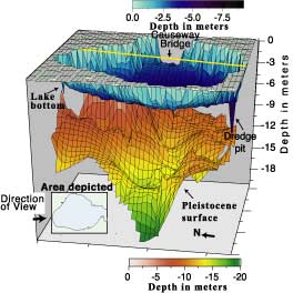 | | Figure 18: Perspective-block diagram of the Pleistocene surface below the lake bottom. The diagram was generated from digitized interpretations of high-resolution seismic profiles (HRSP) such as the ones shown in Figures 21-23. | Other features noted from seismic profiles include fault trends across the Lake (see Figure 20, from Lopez, 1996) and another possible barrier island trend (Milton Island). The HRSP shows reflectors within the Pleistocene sediments affected by deep seated faulting (Figure 23). 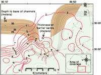 | | 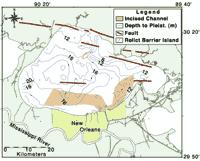 | | Figure 19: Contour structure map showing depth to thalweg of the incised paleochannel (below mean sea level) and isopach of Pine Island barrier trend. Contours were generated from digitized HRSP interpretations and well cuttings. Click on the image for a larger version. | | Figure 20: Map showing structural features across the lake associated with Pleistocene sediments. Click on the image for a larger version. | 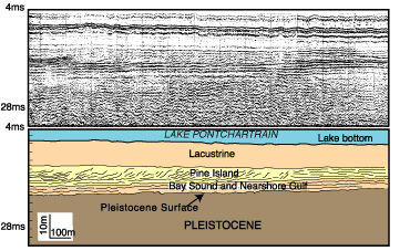 | | Figure 21: HRSP and interpretation showing the Pine Island barrier trend, overlain on Holocene and Pleistocene sediments. |  | | Figure 22: HRSP and interpretation showing large Paleochannel, incising Pleistocene sediments. | 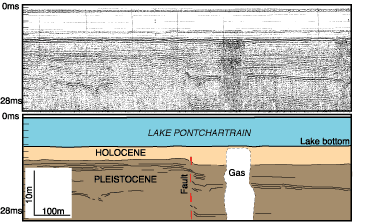 | | Figure 23: HRSP and interpretation showing displacement along reflectors within Pleistocene sediments. Fault trends below resolvable depth of record. | « Previous | Next » |
