| |  |  | | Lake Pontchartrain Atlas: | | | | | | | | | | | | | | | | | | | | | | | | | Basin Geology |  | | | | | | | | | | | | | | | | | | | |  | | | | | | | | | | |  | Basin Geology - Quarternary Framework Contributors: Flocks, Kindinger 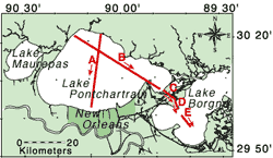 | | Figure 14: Index map showing location of interpreted cross sectional profiles shown in Figure 15. | The recent (<18 kyr) stratigraphy of Lake Pontchartrain is a function of relative sea-level change. A history has been interpreted from High Resolution Seismic Profiles (HRSP) and sediment cores (Figures 14 and 15). The stiff, oxidized clay of the Pleistocene sediments (Figure 16) provides a valuable correlation tool for the regional construction of the recent geologic framework. The Pleistocene surface was aerially exposed and incised by meandering river channels (Figure 15b and e) until the late Wisconsin/Holocene sea-level transgression, about 7 kyr ago. As sea-level rise flooded the embayment, barrier trends (Profile C) and deltaic sequences (Profiles B and E) traversed the area (Figure 17), leaving their mark on the stratigraphic record. Today, lagoonal muds (Figure 16, Unit B) and marsh sediments (Profiles C and D) dominate the environment. 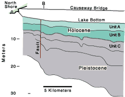 |  | | Figure 15a | | | 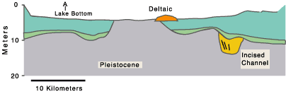 | | Figure 15b | 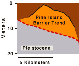 | 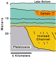 | 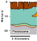 | | Figure 15c | Figure 15d | Figure 15e | | | |
Figure 15: Cross-sectional profile interpreted from 2-D seismic profiles correlated with sediment cores. a) north to south profile along the causeway showing relative position of units A, B, and C and Holocene-Pleistocene contact; b) northwest to southeast transect showing top of the Pleistocene sediments and incised channel fill; c) Pine Island Barrier Trend interpolated from borings (Saucier, 1963); d) Pleistocene and younger sediments adjacent to the Pine Island Barrier Trend, interpolated from borings (Dunbar et al., 1995); and e) northwest to southeast transect across Lake Borgne showing Pleistocene contact and incised channel, interpolated from seismic profiles. |  | Unit A
Brownish gray mud. Shell lag common at base. May be reworked material. | Unit B
Gray to dark gray silty mud with sand filled burrows. Texture coarsens, stiffness and burrowing increase with depth. Basal contact is sharp and erosional. Oyster shells, shell fragments and rip-up clasts may be present at base. Interpreted as Holocene interdistributary and lacustrine (regressive) muds grading downward into silty to sandy nearshore gulf and bay sound (transgressive) deposits at the base. | Unit C
Massive olive gray, very stiff, silty clay with oxidation and oxidized organics. In place rooting, sand filled burrows and diagenetic nodules are common. Interpreted as Pleistocene deposits. | |
Figure 16: Generalized down core description of lithology based on sediment cores (Roth 1999). | 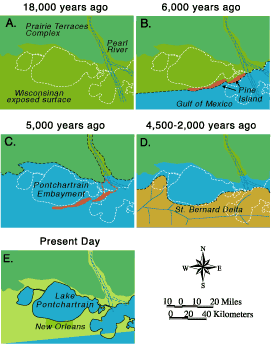 | | Figure 17: Evolutionary model for the Lake Pontchartrain area. | « Previous | Next » |
