Data Series 835
The DEMs are presented as interpolated grids in GeoTIFF format and can be opened directly in Esri ArcGIS 9.3 or higher. The map documents and shapefiles provided in this report were created in Esri ArcGIS 10.1 and can be found in the GIS Project folder. To open this folder in Esri ArcGIS, right-click and choose "Save As". The folder contains the .mxd file and all associated shapefiles and tiffs. The shapefiles provided may also be viewed using other versions of ArcView, ArcGIS, or ArcExplorer software available for download at http://www.Esri.com/software/arcexplorer/. Do not use these data for navigational purposes. The metadata for these files can be found within the metadata folder or by clicking 13CCT01_metadata (53 KB).
| Preview | File Description | File Format | Download File |
|---|---|---|---|
 |
Esri ArcGIS project folder |
Esri files |
|
|
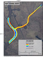
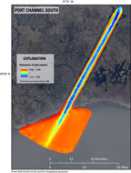
Bathymetry (10-m cell size; UTM) |
Esri Grid 32-bit floating point |
Port_Channel_North_2013_Bathy_SingleBeam_ITRF00_DEM (0.015 MB) |
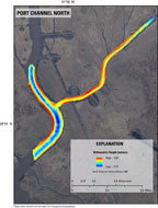 |
Bathymetry (10-m cell size; UTM) |
Esri Grid 32-bit floating point |
|
 |
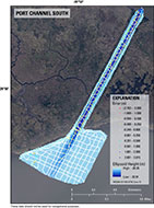
Error (point file; UTM) |
Esri point shapefile |
 |
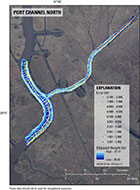
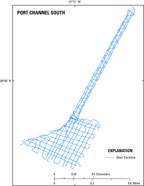
Single-beam tracklines (UTM) |
Esri line shapefile |
XYZ (UTM) |
ASCII |
||
XYZ (UTM) |
ASCII |
||
 |
Esri ArcGIS project folder |
Esri files |
|
|
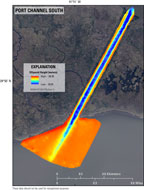
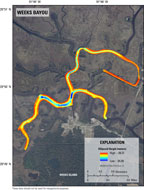
Bathymetry (10-m cell size; UTM) |
Esri Grid 32-bit floating point |
Port_Channel_South_2013_Bathy_SingleBeam_ITRF00_DEM (0.015 MB) |
 |
Bathymetry (10-m cell size; UTM) |
Esri Grid 32-bit floating point |
|
 |
Error (point file; UTM) |
Esri point shapefile |
|
 |
Single-beam tracklines (UTM) |
Esri line shapefile |
|
XYZ (UTM) |
ASCII |
||
XYZ (UTM) |
ASCII |
||
 |
Esri ArcGIS project folder |
Esri files |
|
|
Bathymetry (10-m cell size; UTM) |
Esri Grid 32-bit floating point |
|
 |
Bathymetry (10-m cell size; UTM) |
Esri Grid 32-bit floating point |
|
 |
Error (point file; UTM) |
Esri point shapefile |
|
 |
Singlebeam tracklines (UTM) |
Esri line shapefile |
|
XYZ (UTM) |
ASCII |
||
XYZ (UTM) |
ASCII |
WGS84 (equivalent to ITRF00) and NAD83 have been revised several times, resulting in coordinate shifts of as much as several meters in x,y, and z. The revision is indicated by the designator following the name (G1150 following WGS84, for example). Care should be taken using software that does not distinguish between the different versions of these datums; lack of the designator is a warning sign that software does not support three-dimensional (3D) datum shifts properly. Users should pay particular attention to the accompanying metadata files to ensure that the data are properly georeferenced. In particular, note that most current GIS software (including ArcGIS 10.1) cannot properly transform high-resolution elevation data from one 3D datum to another such as WGS84 (G1150) to NAD83 (CORS96) without introducing errors on the order of 1 m to 2 m in x,y, and z.
The data in this report are provided in UTM zone 15 north horizontal datum of ITRF00 (equivalent to WGS84 G1150), and ellipsoid height in meters. The final data were then converted from this into the horizontal datum of NAD83 (CORS96) and the vertical datum of NAVD88 with respect to GEOID12A. Both the horizontal and the vertical components were transformed using NOAA's VDatum tool version 3.2 (http://vdatum.noaa.gov/).

![]() U.S. Department of the Interior |
U.S. Geological Survey
U.S. Department of the Interior |
U.S. Geological Survey
URL: http://pubsdata.usgs.gov/pubs/ds/0835/ds835_Data_Downloads.html
Page Contact Information: GS Pubs Web Contact
Page Last Modified: Monday, 28-Nov-2016 19:35:49 EST
