|
| | Abstract
|
From August 13 to 23, the U.S. Geological Survey (USGS) conducted geophysical surveys offshore of Petit Bois Island, Mississippi. These efforts are a continued part of the U.S. Geological Survey Gulf of Mexico Science Coordination partnership with the U.S. Army Corps of Engineers (USACE) to assist the Mississippi Coastal Improvements Program (MsCIP) and the Northern Gulf of Mexico (NGOM) Ecosystem Change and Hazards Susceptibility Project, by mapping the shallow geologic stratigraphic framework of the Mississippi Barrier Island Complex.
These geophysical surveys provide the data necessary for scientists to define, interpret, and provide baseline bathymetry and seafloor habitat for this area to aid scientists in predicting future geomorphological changes to the islands with respect to climate change, storm impacts, and sea-level rise. Furthermore, these data, combined with the geomorphological results, provide the properties and extent of local offshore sand sediment resources available for planning and execution of the Gulf Islands National Seashore barrier island restoration.
The geophysical data were collected during one cruise (USGS Field Activity Numbers 13CCT04) aboard the University of Southern Mississippi Research Vessel Tommy Munro offshore along the gulf side of Petit Bois Island, Gulf Islands National Seashore, Mississippi. Data were acquired with the following equipment: a Systems Engineering and Assessment, Ltd., SWATHplus interferometric sonar (468 kilohertz (kHz)), an EdgeTech 424 (4-24 kHz), an EdgeTech 525i chirp subbottom profiling system, and a Klein 3900 sidescan sonar system.
This report serves as an archive of the processed interferometric swath bathymetry and sidescan sonar data. Geographic information system data products include an interpolated digital elevation model, an acoustic backscatter mosaic, a trackline map, and point data files. Additional files include error analysis maps, Field Activity Collection System logs, and formal Federal Geographic Data Committee metadata.
NOTE: These data are scientific in nature and are not to be used for navigation. Any use of trade names is for descriptive purposes only and does not imply endorsement by the U.S. Government. |
|

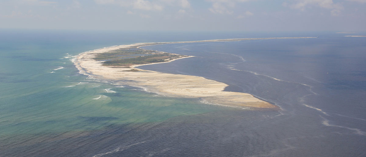
Post Hurricane Isaac oblique aerial photograph looking south-west along Petit Bois Island, Gulf Island National Seashore, Mississippi, September, 2012. Photograph by USGS Coastal and Marine Geology. [Click to enlarge] |
Acknowledgments
The authors would like thank
Funding for this project was provided by the Mississippi Coastal Improvements Program (MsCIP).
http://ngom.usgs.gov/gomsc/mscip/
Christina Urizar at NOAA/NOS/CO-OPS-HPT for her efforts to create the tidal zone model for this cruise.
http://tidesandcurrents.noaa.gov/
Point Cadet Marina Harbor Masters: Richard Johnson, and staff of the City of Biloxi, MS, for the use of their facilities and monitoring.
http://www.biloxi.ms.us/residents/parks-recreation/maritime-harbors/
Captain Chuck Block and crew of the R/V Tommy Munro: University of Southern Mississippi–Gulf Coast Research Laboratory, Point Cadet Marina, Biloxi, MS, for their hard work, flexibility, hospitality, and fine dining.
http://www.usm.edu/gcrl/research_vessels/tommy.munro.research.vessel.php
Information Statement
This DVD publication was prepared by an agency of the United States Government. Although these data were processed successfully on a computer system at the U.S. Geological Survey, no warranty expressed or implied is made regarding the display or utility of the data on any other system, or for general or scientific purposes, nor shall the act of distribution imply any such warranty. The U.S. Geological Survey shall not be held liable for improper or incorrect use of the data described and (or) contained herein. Reference herein to any specific commercial product, process, or service by trade name, trademark, manufacturer, or otherwise does not constitute or imply its endorsement, recommendation, or favoring by the United States Government or any agency thereof.
Suggested Citation
DeWitt, N.T., Flocks, J.G., Kindinger, J.L., Bernier, J.C., Kelso, K.W., Wiese, D.S., Finlayson, D.P., and Pfeiffer, W.R., 2015, Archive of Sidescan Sonar and Swath Bathymetry Data Collected During USGS Cruise 13CCT04 Offshore of Petit Bois Island, Gulf Islands National Seashore, Mississippi, August 2014: U.S. Geological Survey Data Series Report 917 1 DVD, available at https://dx.doi.org/ds917.
Contact
Nancy T. DeWitt
Geologist
U.S. Geological Survey
St. Petersburg Coastal and Marine Science Center
600 4th Street South
St. Petersburg, FL 33701
(727) 502-8000
ndewitt@usgs.gov
(back to top)
|