Data Series 917
|
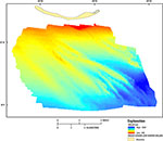
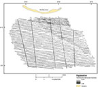
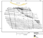
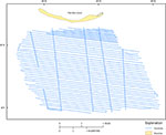
Data DownloadsThe bathymetry grid (DEM) is presented in GeoTiff format and can be opened directly in Esri ArcGIS 10.0 or higher. The map documents and shapefiles in this report were created in Esri ArcGIS 10.1 and can be found in the GIS Project folder. To open this folder in Esri ArcGIS, right-click and choose "Save As". The folder contains the .mxd file and all associated vector and raster data. The data layers may also be viewed using the free GIS viewer ArcGIS Explorer (http://www.esri.com/software/arcgis/explorer).
A Note on Coordinate SystemsWGS84 and NAD83 have been revised several times resulting in coordinate shifts of as much as several meters in x, y, and z. The revision is indicated by the designator following the name (G1150 following WGS84, for example). Care should be taken using software that does not distinguish between the different datum versions; lack of designator is a warning sign that software does not support three-dimensional (3D) datum shifts properly. Users should pay particular attention to the accompanying metadata files to ensure that the data are properly georeferenced. In particular, note that most current GIS software (including ArcGIS 10.1) cannot properly transform high-resolution elevation data from one 3D datum to another (such as WGS84 G1150 to NAD83 CORS96) without introducing errors on the order of 1 meter (m) to 2 m in x, y, and z. The data in this report are provided in WGS84 UTM zone 16 for the horizontal component and MLLW for the vertical component. A tide zone model created by NOAA was applied and verified with six minute water level data for the vertical component. The transformations for the horizontal component from ITRF2005 to WGS84 were converted using NOAA's VDatum tool (http://vdatum.noaa.gov/).
|

![]() U.S. Department of the Interior |
U.S. Geological Survey
U.S. Department of the Interior |
U.S. Geological Survey
URL: http://pubsdata.usgs.gov/pubs/ds/0917/ds917_data_downloads.html
Page Contact Information: GS Pubs Web Contact
Page Last Modified: Monday, 28-Nov-2016 20:36:14 EST