U.S. Geological Survey Data Series 761
1Cherokee Nation Technology Solutions, St. Petersburg, FL 33701.
2U.S. Geological Survey, St. Petersburg, FL 33701.
U.S. Department of the Interior
U.S. Geological Survey - St. Petersburg Coastal and Marine Science Center
Publications are available from USGS Information Services, Box 25286, Federal Center, Denver, CO 80225-0046 (telephone 1-888-ASK-USGS; e-mail: infoservices@usgs.gov).
Page Contents: |
 |
||||||
 |
|||||||
Information StatementThis Digital Versatile Disc (DVD) publication was prepared by an agency of the United States Government. Although these data have been processed successfully on a computer system at the U.S. Geological Survey (USGS), no warranty expressed or implied is made regarding the display or utility of the data on any other system, nor shall the act of distribution imply any such warranty. The U.S. Geological Survey shall not be held liable for improper or incorrect use of the data described and (or) contained herein. Reference herein to any specific commercial product, process, or service by trade name, trademark, manufacturer, or otherwise does not constitute or imply its endorsement, recommendation, or favoring by the United States Government or any agency thereof. System RequirementsThis disc is readable on any computing platform that has standard DVD driver software installed. The minimum software requirements are a Web browser, a Portable Document Format (PDF) reader, and a text editor. Additional features are provided using Google Earth software (http://www.google.com/earth/download/ge/). If you cannot fully access the information on this page, please contact USGS Information Services at infoservices@usgs.gov or 1-888-ASK-USGS. |
|||||||
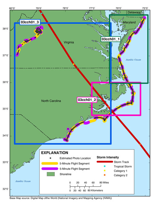
| Figure 1. Map of the post-Hurricane Isabel oblique aerial survey (USGS Field Activity 03CCH01). The flightpath is represented by the alternating purple and yellow line, the photographs by the gray dots along the flightpath, the storm track is a red line (provided by National Oceanograohic and Atomsphereic Administration (NOAA)), and the storm strength indicated by blue, yellow, and orange dots, based on the Saffir-Simpson Hurricane Wind Scale (Saffir, 1973, Simpson, 1974). The region boxes link to more detailed map. The full-resolution photographs are divided by region onto this report's three DVD's | |||||||
On September 21 - 23, 2003, the United States Geological Survey (USGS) conducted an oblique aerial photographic survey along the Atlantic coast from Ocean City, Md., to Fort Caswell, N.C., and inland oblique aerial photographic survey from Waynesboro to Redwood, Va., aboard a Navajo Piper twin-engine airplane (Figure 1). The coastal survey was conducted at an altitude of 500 feet (ft) and approximately 1,000 ft offshore (Figure 2). For the inland photos, the aircraft tried to stay approximately 500 ft above the terrain. These coastal photos were used to document coastal changes like beach erosion and overwash caused by Hurricane Isabel, while the inland photos looked for potential landslides caused by heavy rains. The photos may also be used as baseline data for future coastal change analysis. The USGS and the National Aeronautics and Space Administration (NASA) surveyed the impact zone of Hurricane Isabel to better understand the changes in vulnerability of the Nation’s coasts to extreme storms (Morgan, 2009). This report serves as an archive of photographs collected during the September 21 - 23, 2003, post-Hurricane Isabel coastal and inland oblique aerial survey along with associated survey maps, KML files, navigation files, digital Field Activity Collection System (FACS) logs, and Federal Geographic Data Committee (FGDC) metadata. Refer to the Acronyms page for expansions of all acronyms and abbreviations used in this report.
The USGS St. Petersburg Coastal and Marine Science Center (SPCMSC) assigns a unique identifier to each cruise or field activity. For example, 03CCH01 tells us the data were collected in 2003 for the Coastal Change Hazards (CCH) study and the data were collected during the first field activity for that project in that calendar year. Refer to http://walrus.wr.usgs.gov/infobank/programs/html/definition/activity.html for a detailed description of the method used to assign the ID number.
The photographs provided here are Joint Photographic Experts Group (JPEG) scanned images of the analog 35 millimeter (mm) color positive slides. The photograph locations are estimates of the location of the plane (see the Navigation page). The metadata values for photo creation time, GPS latitude, GPS longitude, GPS position (latitude and longitude), keywords, credit, artist, caption, copyright, and contact were added to each photograph's EXIF header using EXIFtool (Subino and others, 2012). Photographs can be opened directly with any JPEG-compatible image viewer by clicking on a thumbnail on the contact sheet, or, when viewing the Google Earth KML file, by clicking on the marker and then clicking on either the thumbnail or the link below the thumbnail. Nathaniel Plant (USGS - St. Petersburg, Fla.), and Ann Marie Ascough (formerly contracted at the USGS - St. Petersburg, Fla.) helped with the creation of KML files. To view the photos and survey maps, proceed to the Photos and Maps page.
To view the survey maps and navigation files, and for more information about these items, see the Navigation page. Figure 2 displays the acquisition geometry. Table 1 provides detailed information about the assigned location, name, data, and time the photograph was taken along with links to the photo and corresponding 5-min contact sheet. Refer to Table 1 for details of the northern, central, and southern/inland portions of the survey photographs.
NOTE: There were no photographs taken during the 5-min segments beginning at 2003_0922_131919, 2003_0922_134000, 2003_0923_173630, 2003_0923_174000, and 2003_0923_174500.
Figure 1. Post-Hurricane Isabel Oblique Aerial Survey
Figure 2. Acquisition Geometry
Figure 3. Area 1 - Post-Hurricane Isabel Oblique Aerial Survey
Figure 4. Area 2 - Post-Hurricane Isabel Oblique Aerial Survey
Figure 5. Area 3 - Post-Hurricane Isabel Oblique Aerial Survey
Figure 6. Ocean City, Md. - Post-Hurricane Isabel Oblique Aerial Survey
Figure 7. Duck, N.C. - Post-Hurricane Isabel Oblique Aerial Survey
Figure 8. Roanoke Sound, N.C. - Post-Hurricane Isabel Oblique Aerial Survey
Figure 9. Rodanthe, N.C. - Post-Hurricane Isabel Oblique Aerial Survey
Figure 10. Cape Hatteras, N.C. - Post-Hurricane Isabel Oblique Aerial Survey
Figure 11. Cape Lookout, N.C. - Post-Hurricane Isabel Oblique Aerial Survey
Figure 12. Waynesboro, Va. - Post-Hurricane Isabel Oblique Aerial Survey
This report contains links to other resources if access to the Internet is available while viewing these documents. Keyhole Markup Language (KML) files, Hypertext Markup Language (HTML) files, images used to produce the Web pages, and a readme file are also included in this report. Links at the top and bottom of each page provide access to these sections.
The survey's full-size photographs have been divided onto three discs, 03CCH01_1 (Disc 1), 03CCH01_2 (Disc 2), and 03CCH01_3 (Disc 3) (see full survey area map). Each disc contains a KML file with links to the related full-size photographs.
The Disc Contents contains a diagram of the location of all files and folders mentioned in the text and provides links to these files and folders.
To access the information contained on this disc, use a Web browser to open the file index.html. This report is divided into seven sections: Acronyms, Contents, Navigation, Photos and Maps, Logs, and Metadata. Links at the top and bottom of each page provide access to these sections. This report contains links to the USGS and collaborators and to other resources that are only accessible if access to the Internet is available while viewing these documents.
Funding and (or) support for this study was provided by the USGS Coastal and Marine Geology Program (CMGP).
The authors wish to thank Russell Peterson (formerly with the USGS - St. Petersburg, Fla.) and pilot Kurt Miller for their assistance in data collection. The authors would also like to thank Karynna Calderon (formerly contracted at the USGS - St. Petersburg, Fla.), Greg Miller (USGS - St. Petersburg, Fla.), Nathaniel Plant (USGS - St. Petersburg, Fla.), and Ann Marie Ascough (formerly contracted at the USGS - St. Petersburg, Fla.) for their assistance with data post processing. This report benefited from the comments and reviews from Kara Doran (USGS - St. Petersburg, Fla.) and Kristin Sopkin (contracted with Cherokee Nation Technology Solutions at the USGS - St. Petersburg, Fla.).
Morgan, K.L.M., 2009, Coastal change during Hurricane Isabel 2003: U.S. Geological Survey Fact Sheet 2009–3025, 2 p. available online at https://pubs.usgs.gov/fs/2009/3025/.
National Oceanic and Atmospheric Administration (NOAA), 2012, Hurricane Isabel storm track (KMZ), Available online at http://www.srh.noaa.gov/gis/kml
Saffir, H.S., 1973: Hurricane wind and storm surge. The Military Engineer, v. 65, no. 423, p. 4-5.
Simpson, R.H, 1974: The hurricane disaster potential scale. Weatherwise, v. 27, p. 169-186.
Subino, J.A., Morgan, K.L.M., Krohn, M.D., Miller, G.K., Dadisman, S.V., Forde, A.S., 2012, Archive of post-Hurricane Charley coastal oblique aerial photographs collected during U.S. Geological Survey field activity 04CCH01 from Marco Island to Fort DeSoto, Florida, August 15, 2004: U.S. Geological Survey Data Series 651, 2 DVDs, available at https://pubs.usgs.gov/ds/651/
Subino, J.A., Morgan, K.L.M., Krohn, M.D., Dadisman, S.V., 2012, Archive of post-Hurricane Isabel coastal oblique aerial photographs collected during U.S. Geological Survey Field Activity 03CCH01 from Ocean City, Maryland, to Fort Caswell, North Carolina and Inland from Waynesboro to Redwood, Virginia, September 21 - 23, 2003: U.S. Geological SurveyData Series 761, 3 DVDs.
Karen L.M. Morgan
U.S. Geological Survey
600 4th Street South
St. Petersburg, FL 33701
Ph: (727) 803-8747 ext. 3037
FAX: (727) 803-2032
kmorgan@usgs.gov

![]() U.S. Department of the Interior |
U.S. Geological Survey
U.S. Department of the Interior |
U.S. Geological Survey
URL: http://pubsdata.usgs.gov/pubs/ds/761/pubs761/index.html
Page Contact Information: GS Pubs Web Contact
Page Last Modified: Monday, 28-Nov-2016 19:11:40 EST
