|
Sidescan-Sonar Imagery of the Shoreface and Inner Continental Shelf, Wrightsville Beach, North Carolina
|
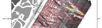
Bathymetry: The bathymetry of the shoreface and inner shelf is strongly controlled by the underlying geologic framework. As shown in Figure 1 (at left), the southern PPvf lithosome forms a broad, relatively shallow platform on the inner shelf. The inner shelf also exhibits a series of east- to northeast-trending, relict ridges with 1-2 meters (m) of relief (Figure 1). The seismic data suggest that the ridges are composed of erosion-resistant Quaternary paleo-fluvial channel-fill sediments (Snyder and others 1994; Thieler 1997). Similar ridges are present along much of the inner shelf south of Wrightsville Beach, where they can be traced roughly along the 10 m depth contour (Snyder and others 1994).
Based on E. Robert Thieler, William C. Schwab, Mead A.
Allison, Jane F. Denny, and William W. Danforth, Sidescan-Sonar Imagery of the
Shoreface and Inner Continental Shelf, Wrightsville Beach, North Carolina: U.S. Geological Survey Open-file Report OF 98-616.
|
Web page: Donna
Newman
[an error occurred while processing this directive]
|
|