|
Sidescan-Sonar Imagery of the Shoreface and Inner Continental Shelf, Wrightsville Beach, North Carolina
|
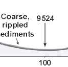
Rippled Scour Depressions: The surficial morphology of the Wrightsville Beach shoreface is dominated by shore-normal to shore-oblique rippled scour depressions (sea-floor depressions floored with rippled, coarse shell hash and gravel [RSDs], a genetic term used by Cacchione and others [1984] to describe similar features in other shelf environments). On the sidescan-sonar mosaic (see Figures 1 and Figure 4), the rippled scour depressions are defined by shore-oblique areas of high acoustic reflectivity. Most of the depressions develop just outside the fair-weather surf zone at 3-4 meters (m) water depth (just seaward of the longshore bar), and extend onto he inner shelf to depths of about 15 m. Several RSDs also appear to originate on the mid-to lower shoreface. The depressions are floored with very coarse shell hash and quartz gravel. Long, straight-crested, symmetric megaripples (wavelength= 0.7-1.2 m, height=0.1-0.25 m) are present within the depressions (Figure 6); ripple crests are oriented roughly parallel to the shoreline.
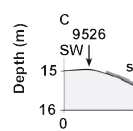
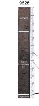
Individual RSDs are approximately 40-100 m wide. They are up to 1 m deep on the upper shoreface, but have a much more subdued (~50 centimeters [cm]) bathymetric expression farther offshore. Figure 7 shows a shore-parallel profile across an RSD on the mid-shoreface. The RSD has approximately 1 m of relief, and is asymmetric with the steeper side to the northeast. The downcore stratigraphy(Figure 8) indicates the center of this RSD is dominated by coarse sediment, with interfingering coarse and fine sediment layers towards the edges. This suggests that this RSD may have existed in the same location for an extended period. In addition, this feature may have formed initially in a pre-existing topographic depression, as evidenced by a thin tidal-inlet sequence overlying an early Holocene backbarrier mud at the base of the RSD sequence.
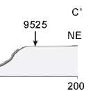
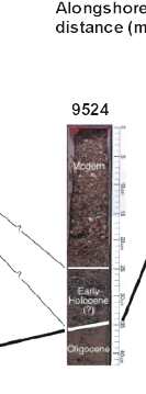
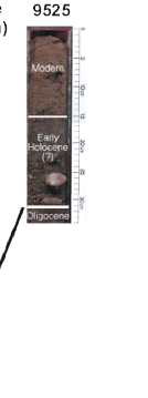
Figure 9. Cross-section and cores taken across the seaward end of the large rippled scour depression shown in Figure 7A (C-C'). Similar to the cores at the inshore end of this rippled scour depression, the center of the feature here is floored by a pre-existing coarse substrate. In this case, the underlying sediment is coarse shell hash and quartz sand, part of an early Holocene (?) estuarine lithosome.
Click on figure to zoom in. |