Surficial Geology and Distribution of Post-Impoundment Sediment of the Western Part of Lake Mead Based on a Sidescan Sonar and High-Resolution Seismic-Reflection Survey
Discussion
Part II
Click on each figure for larger image with caption.
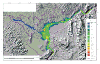
Most of the sediment that has accumulated in the lake since it formed is along the axis of the deep part of the lake (Fig. 7). This distribution suggests that sediment has been contributed to the lake from a few localized point sources rather than a general contribution from all of the surrounding landscape.
If there were multiple sources, sediment pathways should be seen leading from the sources to the lake floor, or the entire lake floor would be draped with a sediment cover.
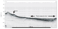
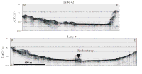
Instead, most of the walls of the lake are barren of recent sediment(see seismic profiles in Fig. 8, Fig. 9, Fig. 10, Fig. 12), and sediment is only present in the floor of Boulder Basin and in the narrow valley floor of Las Vegas Bay (Fig. 7).
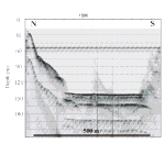
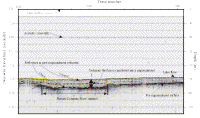
Only discontinuous, thin patches of sediment are seen in the axial valley floors of Swallow Bay, Calvin Bay, and Humbling Bay (Fig. 7). The flat surface of the sediment that fills Boulder Basin, the gentle downslope gradient of this surface from Boulder Canyon to Hoover Dam, and the shallow channel extending westward from Boulder Canyon suggests that the primary source for this sediment is from east of Boulder Canyon. Gold (1951) proposed that the sediments in the floor of Lake Mead were the product of dense turbid flows, derived from the Colorado River, running the full length of the lake. The geometry of the deposits on the lake floor and their internal stratigraphy are consistent with the turbidity current origin proposed by Gold (1951). The seismic profiles show four nearly flat-lying reflectors within the deposit
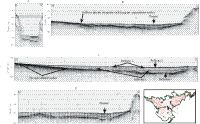
(Fig. 6). The cause of the reflectors is presently unknown, but they could represent sandier beds within a predominantly mud deposit. These reflectors mimic each other, and all show a shallow channel overlying the deepest part of the lake (Fig. 13). Also, the reflectors that extend away from the channel onlap the underlying surface along the basin edge. Where the walls are steep this onlapping is abrupt (Fig. 8), and where the underlying surface has a gentler gradient the reflectors can be seen pinching out against this surface (Fig. 13 C and D).
This pattern is similar to the geometry of other turbidity current deposits that have been extensively mapped in deep-sea settings (Walker, 1992). The stacking of the channels in the four reflectors, one on top of the other, suggests that turbidity currents have continued to be the dominant process of sedimentation in the lake during its 65-year history. If not, the geometry of the reflectors would have changed. The sediment in the lake floor is nearly, but not perfectly flat, but the difference in elevation between the
channel floor and the edge of the sediment is consistently less than 5 m (Fig. 11, Fig. 13B). The fact that the surface of these deposits only slightly laps up on the flanks of the lake suggests that the turbidity flows were thin. This difference in elevation between the channel floor and the edge of the sediment suggests that the turbidity current flows were less than 6-8 m thick.
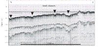
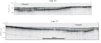
Minor contributions of sediment have been supplied to Lake Mead from Las Vegas Wash as well. Sediment supplied from this source probably was transported as turbulent flows as well because the sediment distribution is limited to the axis of the valley In Las Vegas Bay (Fig. 7). The Las Vegas Wash source is viewed as minor because the thickness of sediment in this valley floor is much thinner than that in the central part of Boulder Basin (Fig. 7, Fig. 12). Additionally, if large amounts of sediment were passing through this valley and being deposited in the floor of Boulder Basin, a fan-like deposit would be present at the mouth of this valley. Figure 16 shows three profiles across the mouth of the valley extending out of Las Vegas Bay, and no fan or channel is present in this area. The discontinuous sediment cover along the length of the channel that floors Las Vegas Bay indicates that sediment derived from Las Vegas Wash is being transported several kilometers into the lake, but that at present, the volume is not large.
|