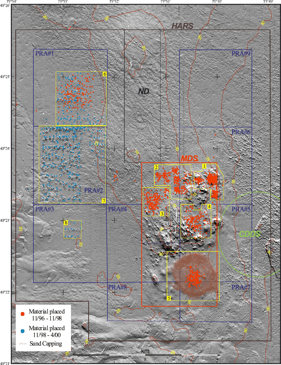
Figure 2.
Shaded relief image of the HARS (collected in 2000) showing locations
of dredged material placed on the sea floor between November 1996 and November
1998 (red dots), between November 1998 and April 2000 (light blue dots), and
tracks for sand capping (brown), based on records of the U.S. Army Corps of Engineers
(See Table 1). The placements are grouped in eight areas
(Areas 1-8, outlined in yellow). For the 1996-1998 placements, the plotted locations are the position of the tug (not
the towed scow) when placement began. The actual location of the material on
the sea floor may differ by several hundred m from this position. For the
1998-2000 placements, the plotted locations are the position of the scow at the
beginning of the placement event, essentially the location of release. For the
sand capping, the lines are the track of the tug as material was released from
the scow. The boundaries of the Historic Area Remediation Site (HARS) (brown),
the Primary Remediation Area (PRA) (divided into 9 cells outlined in blue and labelled PRA #1-9), the Mud Dump Site (MDS) (red), the no-discharge zone (ND) (black), and the western
portion of the Cellar Dirt Disposal Site (CDDS) (green) are also shown. White
areas are areas of no data. The shaded relief image was created by vertically
exaggerating the topography four times and then artificially illuminating the
relief by a light source 45 degrees above the horizon from the north. In the
resulting image, topographic features are enhanced by strong illumination on
the northward-facing slopes and by shadows cast on southern slopes. The shaded
relief image also accentuates small features (relief of a few meters) that could
not be effectively shown as contours alone at this scale. Unnatural-looking features
or patterns oriented parallel or perpendicular to survey tracklines (tracklines
run north-south) are artifacts of environmental conditions during data collection.
Topographic contour interval is 5 m.