|
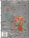
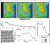
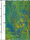
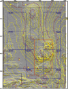
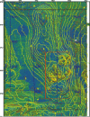
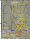
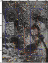
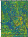
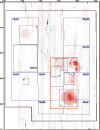
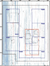
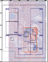
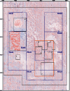
ResultsOne of the most striking aspects of the sea floor shown within the HARS is the variability in backscatter intensity and bottom morphology over scales of a few kilometers or less caused by both natural and anthropogenic processes (Figure 4). The topography, surface features, and the surficial sediments have been heavily influenced by the disposal of dredged and other material in this region over the last century (Williams, 1979; Massa and others, 1996; Butman and others, 1998, https://pubs.usgs.gov/openfile/of98-616/; Schwab and others, 2000, https://pubs.usgs.gov/openfile/of00-295/) .There are two relatively smooth topographic rises in the northern part of the HARS, each approximately 2 km in diameter (Figure 4 and 5). The two rises are composed of material dumped from the late 1800's to the 1990's (Williams, 1979). The northern rise (shallowest point at 40° 25.5' N. and 73° 51.6' W.), referred to as Castle Hill, is material dumped prior to the 1930's. The southern rise (shallowest point at 40° 24' N. and 73° 51.75' W.) is composed of material dumped between 1930 and 1975. The crests of these rises are about 16 meters below the sea surface, approximately 8 meters shallower than the adjacent sea floor to the west. The material on the crest of the northern rise is shaped into a series of sand waves with crests running approximately northwest-southeast. The amplitude of these sand waves is less that 2 meters. Patches of strong backscatter intensity are superimposed on a background of weak backscatter (Figure 5b). Along the crests of the mounds the background backscatter intensity is weak (dark); it grades to a stronger return (lighter) on the flanks at a water depth of about 20 meters (Figure 5c, see also figures 6c and 7c). This transition is clearest on the western side. The MDS is marked by several mounds of material that extend to within about 15 meters of the surface; the shallowest mounds (at 40° 22.7' N., 73° 50.98' W. and 40° 22.97'N, 73° 50.01'W.) are about 12 meters below the sea surface. Elongate paired features, on the order of 50 to 75 meters long and 40 meters wide, are scattered throughout the site. Their relief typically is about 1 meters and some of the features are separated by depressions about 1 meters deep. It is hypothesized that these are signatures of individual dumps of material from barges. Linear features, on the order of 100 meters long and aligned northwest-southeast, are observed on the saddle (40° 23.25' N. and 73° 51.4' W.) between the southern disposal mound and the present disposal site at water depths between 16 and 18 meters. These linear features have about 0.5 meters of relief. A few features with similar characteristics are observed to the north of the southern disposal mound. These features may result from placement of material from pocket scows that released material sequentially from multiple compartments. Throughout the survey area, individual features ranging from a few meters (the resolution of the system) to about 50 meters in diameter are apparent in the shaded-relief and backscatter intensity images. Some of the features are topographic highs and some are depressions with a small high in the center. These features are hypothesized to result from disposal of individual scow loads of dredged material. The features are characterized by their relief and high backscatter intensity. In the area shown in Figures 5-7, the depression features are primarily located in the region north of 40° 24.5' N. between 73° 49' W. and 73° 51' W. where the substrate is fine sand and mud. However, these features are ubiquitous in other areas of the New York Bight (see Butman and others, 1998, https://pubs.usgs.gov/openfile/of98-616/). The depressions are typically 0.5 to 1 meters deep and some have a central mound 0.25 to 0.5 meters high. Many of the features occur in linear groupings of 5 or more and are often aligned in a northwest-southeast direction. This pattern is consistent with disposal from ships steaming to, or from, New York Harbor. The depressions may have formed during disposal as material impacted the sea floor, or may be a result of scour by currents and/or animals around the dumped material. In contrast to these depressions, the targets in the area south of 40° 24' N. and between 73° 49' W. and 73° 49.5' W. appear as topographic highs where the substrate is gravel and boulders (see Butman and others, 1998, https://pubs.usgs.gov/openfile/of98-616/). Some of the features may be derrick stones, large rocks that required a derrick to unload from barges (Williams, 1979), or other rock rubble. Since the early 1900's, the disposal region for derrick stones was 4 to 6.25 nautical miles southeast of Scotland Light (located at approximately 40° 27' N., 73° 55.7' W.), roughly the location of the MDS. Although most of the individual targets now visible are to the east of the MDS, disposal was probably not confined to the designated sites. The linear alignment of the features suggests an anthropogenic origin, and the distribution suggests that large areas of the sea floor outside of the designated disposal sites have been affected by past ocean disposal. An area of uniformly smooth topography and low backscatter intensity extends to the northeast, east, and southeast of the MDS for about 1-2 km (see region between 40° 22.5' N. and 40° 24' N. along 73° 50' W.) in the 1996 survey (Figure 6b). The absence of the backscatter and topographic signatures of individual dumps in this area, which are ubiquitous throughout much of the adjacent area, suggests that this area may be floored with fine material winnowed form the MDS and transported eastward and downslope. The composition of the two surface sediment samples (stations 38 and 48, Table 3) obtained in this region, are both clayey silt. Another region of relatively smooth topography and low backscatter (between 40° 22' N. and 40° 23' N. and centered at 73° 52.5' W.) is found to the west of the MDS. All of these broad areas characterized by low-backscatter intensity are within the area of the HARS to be remediated by capping. The western edge of outcropping beds of coastal plain strata (Schwab and others, 2000, https://pubs.usgs.gov/openfile/of00-295/), probably of Cretaceous age, is visible at 40° 23' N. and 73° 49' W. Individual mounds, hypothesized to be disposed material, lie on this hard substrate, which is located within the old Cellar Dirt Dump Site (Figure 2). To the west of the outcropping strata is a shallow northwest-southeast trending channel, 2-4 meters deep, and about 400 meters wide that is floored by fine-grained sediments. The channel is cut into Cretaceous strata and is Pleistocene or early Holocene in age. The channel may be a pathway for movement of sediments from the shelf to the western side of the Hudson Shelf Valley. The presence of small targets in this channel, interpreted as individual piles of rock or gravel, implies scouring around these features, or non-burial as a result of relatively slow accumulation. In the 1996 survey, a circular region approximately 1 km in diameter in the southern part of the MDS (centered at 40° 22' N. and 73° 51' W.) is characterized by relatively low backscatter intensity (Figure 5b). Within the circular region, there are at least 10 individual mounds less than 2 meters in height. This feature and associated subfeatures is located in the experimental quadrant of the MDS, known as Ex. MDS, where sediments contaminated with dioxin were disposed in this area and capped with sand in the early 1980's. The site was subsequently used during the Dioxin Capping Projects of 1993 and 1997 (see below). Changes between 1996 and 1998: The surveys clearly identify regions where the depth of the sea floor decreased between 1996 and 1998 (Figure 8a). All of the areas of shallower water are areas where dredged material was placed between the 1996 and 1998 (Areas 1, 2, 4, 5 and 6). The highest mound, located in Area 1 and centered at about 40° 23.55' N., 73° 50.08' W., is approximately 400 meters in diameter. New accumulation in the center of this feature exceeds 7 meters. Smaller mounds in Area 1, on the order of 150 meters in diameter, are located to the west and south; new accumulation exceeds 3 meters and in some places 4 meters in these areas. The largest area of accumulation is in a circular feature about 1 km in diameter, centered at about 40° 22.25' N. and 73° 50.45' W. (Area 5). Contaminated sediment was placed in this location and capped with sand from Ambrose Channel in 1997. The increase in sediment thickness ranges from about 1 meters at the outer edge of the cap, to about 3 meters near the center (see transect E-F in Figure 3). The western side of this accumulation overlies the site of an earlier disposal and capping project involving dioxin-contaminated sediments. The backscatter difference map (Figure 9a) shows decreased backscatter intensity on the eastern side of the cap between 1996 and 1998. A circular feature about 900 meters across and centered at about 40° 24.75' N., 73° 52.8' W., reflects remediation activities in the northwest part of the HARS (Area 6). The change in surficial sediment reflectivity of the capping material is clearly seen in the backscatter intensity map (Figure 6b) and in the pseudo-colored backscatter map (Figure 6c), and in the backscatter intensity difference map (Figure 9a). The feature is approximately 0.5 m thick (see transect A-B in Figure 3). Within the overall feature, there are small mounds of material about 1 meters in height and of order 100 meters horizontally which are thought to be formed from the remedial capping. Some of the areas of sediment accumulation associated with newly placed material show increased backscatter intensity (Figure 9a, Areas 1 and 4) from 1996 to 1998, while some show a decrease in backscatter intensity (Areas 2, 3, eastern portion of Area 5, and Area 6). These changes in backscatter intensity may reflect changes in sediment properties and/or microtopography such as texture, dewatering, compaction, ripple formation, and benthic reworking. Two areas that received dredged material (Areas 2 and 3) show only a minimal change in water depth but a decrease in backscatter intensity. The areas showing least change in backscatter intensity between the 1996 and 1998 surveys are broad areas of low backscatter intensity (dark blue areas in the southwest part of the map centered at 40° 22.5' N., 73° 52.5 W'.; eastern part of the map centered at 40° 24.0' N., 73° 50.0' W., and along the crest of the ridge centered at 73° 51.5' W., see figure 4, and 5-7c). These are interpreted to be areas of long-term fine-sediment accumulation where the addition of fine sediment from distant sources would not alter the backscatter intensity characteristics. Across the entire survey area, the average difference in depth between 1996 and 1998 was 24 cm (1998 shallower than 1996) and the standard deviation was 36 cm (Figure 8a); the difference is within the 30 cm accuracy of the Simrad EM1000 mapping system. The north-south striping of the topographic difference is most likely caused by refraction error at the outer edge of the survey swaths. The 'noisy' or speckled pattern in the backscatter intensity difference map that occurs throughout the survey area (Figure 9a) (especially noticeable away from the areas of consistent or no change) are hypothesized to partially result from critical angle effects, where the intensity of the reflected sound varies as a function of the angle of incidence. Since the angle of incidence for a particular location is not the same during each survey, this effect will produce noise in the backscatter intensity difference, most prominently displayed in lines parallel to the ship track. Changes between 1998 and 2000: Placement of new capping material in the western two-thirds of PRA#2 between November 1998 and April 2000 (see Figure 2) resulted in features that appear as craters 30 to 70 meters long and of order 20 meters wide, with the major axis oriented roughly north-south (Figure 7a and 7c). The craters have elevated rims and depressions in the center and were apparently formed as the placed material impacted the soft sea floor. Most of the craters are in rows oriented east-west and spaced north-south by about 250 meters and are characterized by increased backscatter intensity (Figure 6c, 7c, and 9b). Placement of capping material in the northeastern portion of PRA#2 (Figure 2) resulted in decreased backscatter intensity (7b and Figure 9b). Some of the area characterized by low backscatter intensity in PRA#1 in the 1998 survey appears as higher backscatter intensity in the 2000 survey (Figure 7b, 9b). Some of the higher backscatter intensity is the result of the placement of new capping material (Figure 2). The changes in backscatter intensity may also reflect changes in sediment properties and/or microtopography such as texture, dewatering, compaction, ripple formation, and benthic reworking. Increased backscatter intensity on local topographic features formed during the placement of material prior to the 2000 survey may be the result of winnowing of material between 1998 and 2000. For example, see the increased backscatter intensity centered near 40° 24.85' N. and 73° 52.62' W., 40° 24.87' N. and 73° 53.09' W., and 40° 24.64 'N. and 73° 52.6' W. Across the entire survey area, the average difference in depth between 1998 and 2000 survey was -14 cm and the standard deviation was 33 cm (Figure 8b); the difference is within the 30 cm accuracy of the Simrad EM1000 mapping system. The western 1 km of the survey area, all surveyed on April 6th, 2000 shows a systematic decrease in depth (blue area in Figure 8b); the cause of this apparent survey artifact is not understood. Mass Balance: Changes in depth and backscatter intensity associated with newly placed material are clearly identifiable in the topographic and backscatter intensity maps of the HARS. However, the resolution of the multibeam system precludes utilizing differences in depth measured between repeated surveys to estimate the amount of material placed in theHARS, because modest amounts of material were placed over a large area. For example, the resolution limits of the Simrad EM1000 of 30 cm amounts to an uncertainty of about 300,000 meters3 of material over a 1 km2 area, equivalent in magnitude to the volume of material placed in each of the Areas (Figure 2, Table 1). In addition, more information on the amount of material contained within each scow is needed to determine the volume placed at each site (the volume of the scow was used to develop the volume estimates in Table 1 with no correction for water content), and compaction rates of the material on the sea floor are needed in order to estimate the amount of placed material on the sea floor from the measured topographic differences. However, despite these uncertainties, the data suggests little net accumulation in Area 3, compared to the other Areas that received similar amounts of material (Figure 8a, Table 1). The material placed in Area 3 was mud and silt which is easily eroded, and some spreading and transport of material is expected at this shallow site. The repeated multibeam surveys are most useful in identifying the location of new material placed on the sea floor and changes in surficial characteristics through time based on changes in backscatter intensity. |
| |||||||||||||||

Download Adobe Acrobat Reader at http://www.adobe.com/support/downloads/main.html. [an error occurred while processing this directive] | |||||||||||||||||