|
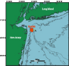
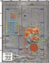
IntroductionAn area offshore of Sandy Hook, New Jersey, has been used extensively for disposal of dredged and other materials, derived from the New York/New Jersey Harbor and surrounding areas, since the late 1800's (Figure 1). Between 1976 and 1995, the New York Bight Dredged Material Disposal Site, also known as the Mud Dump Site (Figure 2), received on average about 6 million cubic yards of material each year from federal and private maintenance dredging and from harbor deepening activities (Massa and others, 1996). In September 1997 the Mud Dump Site (MDS) was closed as an official ocean disposal site by the U.S. Environmental Protection Agency (http://www.epa.gov/), and the MDS and surrounding areas were designated as the Historic Area Remediation Site (HARS). The HARS is subdivided into a Primary Remediation Area (PRA, subdivided into 9 cells), a Buffer Zone, and a No-Discharge Zone (Figure 2). The sea floor of the HARS, approximately 9 square nautical miles in area, is being remediated by placing at least a one-meter cap of Category I (clean) dredged material on top of the existing surface sediments that exhibit varying degrees of degradation. (See http://www.nan.usace.army.mil/business/prjlinks/dmmp/benefic/hars.htm)(Category I sediments have no potential short or long-term impacts and are acceptable for unrestricted ocean disposal (EPA, 1996)). About 1.1 million cubic yards of dredged material for remediation was placed in the HARS in 1999, and 2.5 million cubic yards in 2000. Three multibeam echosounder surveys were carried out to map the topography and surficial geology of the HARS. The surveys were conducted November 23 - December 3, 1996, October 26 - November 11, 1998, and April 6 - 30, 2000. The surveys were carried out as part of a larger survey of the Hudson Shelf Valley and adjacent shelf (Butman and others, 1998, (https://pubs.usgs.gov/openfile/of98-616/). This report presents maps showing topography, shaded relief, and backscatter intensity (a measure of sea floor texture and roughness) at a scale of 1:25,000. Comparison of the topography and backscatter intensity from the three surveys show changes in topography and surficial sediment properties resulting from placement of dredged material in 1996 and 1997 prior to closure of the Mud Dump Site, as well as placement of capping material for remediation of the HARS. The surficial geology and sediments of the HARS and the surrounding region are described in Butman and others (1998), (https://pubs.usgs.gov/openfile/of98-616/, Schwab and others (1997, 2000, https://pubs.usgs.gov/openfile/of00-295/). A history of waste disposal in the New York Bight region is presented in Massa and others (1996). |
| |||||||||||||||||

Download Adobe Acrobat Reader at http://www.adobe.com/support/downloads/main.html. [an error occurred while processing this directive] |
|||||||||||||||||||