| Data Collected |
92023
Deep towed chirp: 58 km of deep-towed data. See map for trackline locations. On the map solid lines refer to 1992 data.
Side Scan Sonar: 78 km2 sidescan mosaic
Air gun single channel seismic reflection: approximately 1000 km of profiles. These data were reported by Taylor, M. Dillon, W. Anton, C., and Danforth, W., 1999, Seismic reflection surveys of the Blake Ridge, R/V Cape Hatteras 1992 and 1995: Data acquisition, navigation and processing, U.S. Geological Survey Open File Report 99-372 (2 CD-ROMs).
|
95023
Deep towed chirp: 100 km of
deep-towed data. See map for trackline
locations. On the map dashed lines refer the 1995 data
Side Scan Sonar: 152 km 2 sidescan mosaic
GI gun single channel seismic reflection: approximately 244.3 km of profiles.
This dataset was collected in conjunction with the Ocean
Drilling Program Leg 164.
|
| Further Cruise- Report Items |
| CRUISE SERIAL NUMBER: | 92023 |
|---|
| Alternate Leg or Cruise Number: | CH 12-92 |
|---|
| Platform: | CAPE HATTERAS |
|---|
| Submersible (if any): | |
|---|
| Owner-Operator: | Duke, UNC |
|---|
| Captain: | |
|---|
| Center Principal and Affiliate Principal(if any): | W. Dillon, W. Schwab;
|
|---|
| Area of Operations: | Blake Ridge |
|---|
| Bounding Coordinates | |
|---|
| North: | 31 30 33N |
| South: | |
| West: | -75 76 30 |
| East: | |
| Start and End Dates: | SEP 21, 1992 to OCT 4, 1992 |
|---|
| Start and End Ports: | from Morehead City to Morehead City |
|---|
| Number of Days at Sea: | 14 |
|---|
| Cruise Objectives: | To obtain digital seismic profiles in the area of gas hydrate development on the continental rise of N. and S. Carolina. To test and obtain data from the new USGS/Datasonics deep-towed sidescan sonar system. |
|---|
| Scientific Party |
| Crew Member |
Affiliation |
Duties |
| William Dillon |
USGS, Woods Hole, MA |
Co- Chief Scientist |
| William Schwab |
USGS, Woods Hole, MA |
Co- Chief Scientist |
| Tommy O'Brien |
USGS, Woods Hole, MA |
Scientist |
| B. Irwin |
USGS, Woods Hole, MA |
Scientist |
| L. Kooker |
USGS, Woods Hole, MA |
Scientist |
| William Danforth |
USGS, Woods Hole, MA |
Scientist |
| J. Gann |
USGS, Woods Hole, MA |
Scientist |
| Dwight Coleman |
USGS, Woods Hole, MA |
Scientist |
| Timothy Boynton |
Duke Marine Lab, Beaufort, NC |
Science Liaison |
| Fred Hegg |
Datasonics Inc., Boston, MA |
Equipment Consultant |
| Mark Parent |
Datasonics Inc., Boston, MA |
Equipment Consultant |
|
| Scientific Equipment: | 2-channel srp w/160 cu. in. airgun, 30 kHz deep-towed SSS, 3.5 kHz profiling system; integrated loran-C (SAIL) system-Duke; |
|---|
| Navigation techniques used: | DGPS |
|---|
| Cruise Funding Source: | |
|---|
| Project Title: | |
|---|
| Contract: | |
|---|
| Remarks: | |
|---|
| Tabulated Information: | |
|---|
| Days at Sea: | 14 |
|---|
| Continuous Data (in Km): | 1458 |
|---|
| Number of Stations Occupied: | |
|---|
| Number of Submersible Dives: | |
|---|
| Station Description: | |
|---|
| Seismic Line Descriptions: | |
|---|
| Track Plot: | |
|---|
| Related Web Sites: | |
|---|
Report Date: 8:51 1/5/1998
Submitted by: Bill Dillon
|
| CRUISE SERIAL NUMBER: | 95023 |
|---|
| Alternate Leg or Cruise Number: | CH 17-95 Leg1 |
|---|
| Platform: | CAPE HATTERAS |
|---|
| Submersible (if any): | |
|---|
| Owner-Operator: | Duke/UNC |
|---|
| Captain: | Dick Ogus |
|---|
| Center Principal and Affiliate Principal(if any): | Bill Dillon
Joe Gettrust-NRL-Stennis Space Center |
|---|
| Area of Operations: | Blake Ridge/Spur, SC |
|---|
| Bounding Coordinates | |
|---|
| North: | 32.1 |
| South: | 31.5 |
| West: | -76. |
| East: | -75.3 |
| Start and End Dates: | OCT 11, 1995 to OCT 19, 1995 |
|---|
| Start and End Ports: | from Beaufort, NC to Beaufort, NC |
|---|
| Number of Days at Sea: | 9 |
|---|
| Cruise Objectives: | Sidescan sonar, seismic imaging of Blake Ridge collapse structure. |
|---|
| Scientific Party |
| Crew Member |
Affiliation |
Duties |
| William Dillon |
USGS, Woods Hole, MA |
Co- Chief Scientist |
| William Schwab |
USGS, Woods Hole, MA |
Co- Chief Scientist |
| Tommy O'Brien |
USGS, Woods Hole, MA |
Scientist |
| B. Irwin |
USGS, Woods Hole, MA |
Scientist |
| L. Kooker |
USGS, Woods Hole, MA |
Scientist |
| William Danforth |
USGS, Woods Hole, MA |
Scientist |
| J. Gann |
USGS, Woods Hole, MA |
Scientist |
| Dwight Coleman |
USGS, Woods Hole, MA |
Scientist |
| Timothy Boynton |
Duke Marine Lab, Beaufort, NC |
Science Liaison |
| Fred Hegg |
Datasonics Inc., Boston, MA |
Equipment Consultant |
| Mark Parent |
Datasonics Inc., Boston, MA |
Equipment Consultant |
|
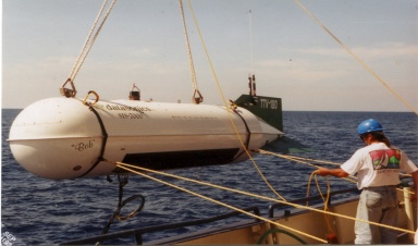
| Scientific Equipment: | 2-channel digital seismic system, 160 cu in airgun, Datasonics SIS-7000 mid-range sidescan sonar (Bob) system; NRL sidescan system |
|---|
| Navigation techniques used: | DGPS and P-Code |
|---|
| Cruise Funding Source: | |
|---|
| Project Title: | Gas Hydrate |
|---|
| Contract: | |
|---|
| Remarks: | |
|---|
| Tabulated Information: | |
|---|
| Days at Sea: | 9 |
|---|
| Continuous Data (in Km): | |
|---|
| Number of Stations Occupied: | |
|---|
| Number of Submersible Dives: | |
|---|
| Station Description: | |
|---|
| Seismic Line Descriptions: | |
|---|
| Track Plot: | |
|---|
| Related Web Sites: | |
|---|
Report Date: 15:50 5/16/2001
Submitted by: Tom O Brien
|