Deep-Towed Chirp Profiles of the Blake Ridge Collapse Structure: USGS OFR 01-123
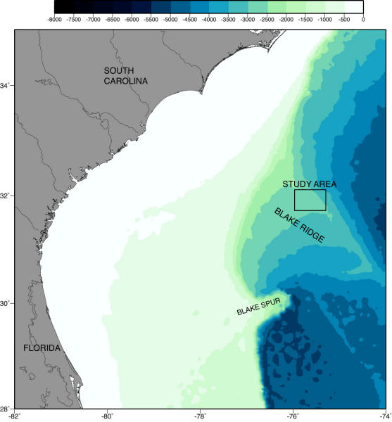
The data released in this report were collected over an area some 300 km offshore of South Carolina on the crest of the Blake Ridge in water depths of about 2600 m. Eight deep-towed, subbottom profile ("chirp") lines were collected across a depression in the sea bottom known as the Blake Ridge collapse structure, where we believe large quantities of methane, approximately 4% of the present atmospheric total, was released from seafloor sediments.
Click on the images for larger illustrations.
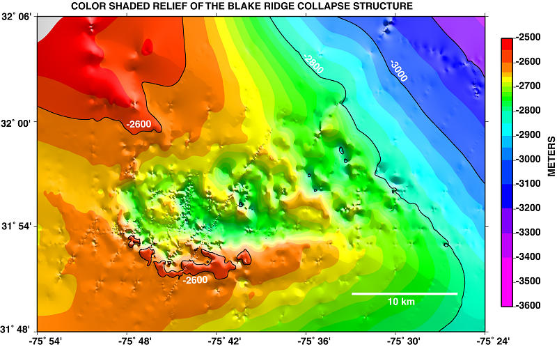
The Blake Ridge is a large sediment drift deposit that is migrating toward the southwest at approximately 2600 m of water depth. The migration results in accretion on the southwestern flank of the ridge and erosion of the northeastern flank as seen in the USGS long-range sidescan sonar images (Figs. 3 and 4; EEZ-Scan 87, 1991).
This effort was undertaken to build an accurate picture of how the collapse structure formed, the relationship of gas hydrate processes to seafloor stability, and the exchange of methane from the seafloor to the atmosphere. The deep-towed chirp profiles and sidescan mosaic provide detailed imagery of the seafloor and near-surface features within the collapse. The structure is characterized by large shallow dipping faults on its southwestern side (Fig. 5; Taylor, et al., 1999) and slumping and folding on its northeastern side. Lithologic and age data have been acquired from several scientific wells drilled just southwest of the collapse structure; a profile through those wellsites is shown in Fig. 6 (Paull, C.K. et al. 2000). By reconstructing the collapse it has been estimated that 13 cubic kilometers of sediment have been expelled into the water column including 405 million cubic meters of hydrate which would expand to 68.9 billion cubic meters of methane at atmospheric conditions.
To study this feature the USGS cooperated with other organizations including the Department of Energy, the Ocean Drilling Program, Monterey Bay Aquarium Research Institute, University of North Carolina, Duke University, University of Wyoming, and other scientific organizations.
The deep-towed chirp and sidescan data were acquired during two research cruises, both aboard the R/V Cape Hatteras, from the Duke University Marine Lab in Beaufort, North Carolina. The work aboard the R/V Cape Hatteras in 1995 was part of a companion cruise to the Ocean Drilling Program Leg 164. Lines numbered 7-11 (east-west in orientation) were taken in 1995. Lines 24-27 (northeast-southwest) are from 1992.
Click on map for larger image and data access.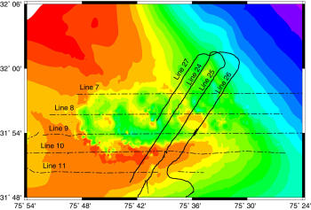
|
Mosaic of 1995 Sidescan-sonar Imagery Click figure for larger image. 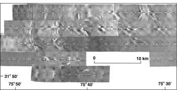
|
The study was part of an ongoing project in natural gas hydrate research. Natural gas hydrates are an ice-like crystalline combination of water and gas, most commonly methane. Natural gas hydrates are found in abundance in permafrost regions and in deep seafloor sediments where the low temperature and high pressure conditions necessary for their formation exist. Since most natural gas hydrate is formed with methane, and methane is a reactive green house gas, the release of methane from naturally occurring hydrate deposits to the atmosphere can have a profound impact on global climate.
For a partial listing of USGS papers and other data sets regarding the Blake Ridge collapse structure and natural gas hydrates see the References.
![]() Document Homepage --
1. Introduction --
2. Cruise Reports -- 3. Track Map -- 4. Data Files and Descriptions -- 5. References -- 6. Metadata files -- 7. Help
Document Homepage --
1. Introduction --
2. Cruise Reports -- 3. Track Map -- 4. Data Files and Descriptions -- 5. References -- 6. Metadata files -- 7. Help