Deep-Towed Chirp Profiles of the Blake Ridge Collapse Structure: USGS OFR 01-123
The numerical data files of ship navigation and bottom-towed chirp profiles of the two cruises of the Cape Hatteras in this area are in two directories, navdata, and segydata, respectively.
Illustrations of the profiles with links to their data files are found on pages 4.1. 1992 Chirp Profiles and 4.2. 1995 Chirp Profiles.
The data files and their illustrations can be accessed most easily and clearly by using the interactive trackline map in this report.
Note that these cruises also acquired approximately 1000 km of air-gun (surface-towed) single-channel seismic reflection profiles. Those data were reported by Taylor, M. Dillon, W. Anton, C., and Danforth, W., 1999, Seismic reflection surveys of the Blake Ridge, R/V Cape Hatteras 1992 and 1995: Data acquisition, navigation and processing, U.S. Geological Survey Open File Report 99-372 (2 CD-ROMs).
See 4.1. 1992 Chirp Profiles and 4.2. 1995 Chirp Profiles for the chirp profiles, illustrated, with navigation and SEGY reflection-data links.
The Datasonics Inc. SIS 7000 deep-towed sidescan sonar and chirp profiling unit was developed in 1990 in conjunction with the USGS. Nicknamed "Bob", the unit is able to be towed at great depths (more than 3000 meters) in order to create images of the deep sea floor. The "Bob" has 5 data channels, 2 sidescan, 2 bathymetry, and 1 chirp channel. Only the sidescan and chirp channels were used during these cruises.
On cruise 92023, 58 km of deep-towed chirp data were recorded on 4 lines and broken into a total of 8 files. 78 square kilometers of sidescan mosaic and approximately 1000 km of air gun single channel seismic reflection data were recorded as well but are not achived on this report. On cruise 95023, 100 km of deep- towed chirp data were recorded on 5 lines and broken into 18 files. 152 square kilometers of sidescan mosaic and 244.3 km of GI gun single channel seismic reflection were also recorded but are not archived on this report.
The archived Chirp subbottom data are in standard Society of Exploration Geologists (SEG) SEG-Y format (Barry and others, 1975) and may be downloaded for processing with software such as Seismic Unix or SIOSEIS. The subbottom data were recorded on the ISIS data acquisition system in QMIPS format. Chirp subbottom channel extracted from raw QMIPS format sonar files and converted to 16-bit Int. SEG-Y format using the program QMIPSTOSEGY. Even though the data are in SEG-Y format, it is not the conventional time series data (e.g. voltages or pressures), but rather instantaneous amplitude or envelope detected and therefore all of the amplitudes are positive (though not simply rectified).
The shotpoint navigation for the two sets of deep-towed chirp lines was done differently in the two years.
For the 1992 dataset, corrected differential GPS measurements were taken for each shot and written into the Qmips header. Navigation information could then be extracted using the listqmips tool.
The 1992 navigation files are designated as follows YYl#f#.txy, Where YY refers to the year of the survey l# the line number and f# the segment of the line.
Each navigation file begins with 6 line header record containing the following information pertaining to the actual raw qmips data format from which the navigation files were derived. This header information can be ignored when using these files for navigation.
All of the files are ascii text files containing the following information.
| column 1 | column 2 | column 3 | column 4 | column 5 | column 6 | column 7 | column 8 | column 9 |
|---|---|---|---|---|---|---|---|---|
| 10/16/92 | 05 | 56 | 56 | 0.93 | -75.392164 | 31.868297 | scan | 1187 |
| date (mm/dd/yy) | hour (00-23) | minute (00-59) | second (00-59) | decimal second (0.00-0.99) | longitude (-180to+180) | latitude (-90to+90) | denotes next column type | trace scan number |
Navigation files for 1992
For the 1995 dataset, only uncorrected GPS measurements for each shotpoint were written into the Qmips header. A complete set of corrected differential GPS measurements were recorded aboard the ship every 10 seconds. The header records were then matched with the accurate 10 second navigation points to produce a shotpoint navigation file. This file contains accurate positions for only those shots that corresponded with the 10 second navigation files. Therefore these files contain only every second or third shot.
The navigation files for the 1995 data set are designated as follows YYl#f#.nav. Where YY refers to the year of the survey l# the line number and f# the segment of the line.
All of the files are ascii text files containing the following information:
| column 1 | column 2 | column 3 | column 4 |
|---|---|---|---|
| -75.634300 | 31.928499 | 288:09:04:20 | 56 |
| longitude (-180to+180) | latitude (-90to+90) | shot time and date code jd:hh:mm:ss | shot number |
Navigation files for 1995
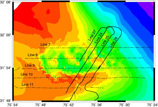
Map showing tracklines over Blake Ridge collapse feature. Click on the map for the larger image with data links.
![]() Document Homepage --
1. Introduction --
2. Cruise Reports -- 3. Track Map -- 4. Data Files and Descriptions -- 5. References -- 6. Metadata files -- 7. Help
Document Homepage --
1. Introduction --
2. Cruise Reports -- 3. Track Map -- 4. Data Files and Descriptions -- 5. References -- 6. Metadata files -- 7. Help