OF 02-152 Home
DVD-ROM Contents
Geologic
Discussion
GIS Data
Contacts
|
Coastal-Plain Strata
The deepest seismic-stratigraphic unit
resolved in the seismic-reflection data is interpreted to be composed
of Upper Cretaceous - to lower Tertiary, semi-lithified, coastal-plain
strata (Williams, 1976; Schwab and others, 1997a, 1997b, 2000a).
These strata are recognizable on subbottom profiles as a series
of conformable bedding planes with high-amplitude returns (Fig.
11). coastal-plain sedimentary units in the region (onshore)
consist of Upper Cretaceous interbedded silty sand and gravel of
the non marine Matawan Group, overlain by Cretaceous
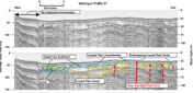 |
| Figure 11. image of seismic-reflection profile displaying Coastal Plain Unconformity. Also link to larger image. |
glauconitic silt and sand units of the marine Monmouth Group, and
lower Tertiary, shallow marine, glauconitic, clayey, to fine- sand
units of the Vincetown and Manasquan Formations (Owens and Minard,
1960; Perlmutter and Todd, 1965; Enright, 1970; Williams, 1976; Williams
and Meisburger, 1987). On Long Island, and on the inner continental
shelf off Long Island, the entire Tertiary section is missing (Suter
and others, 1949; Williams, 1976; Soren, 1978; Smolensky and others,
1989).
The coastal-plain reflectors have
a low angle (~1º), monoclinal, southeast dip that varies slightly
over the study area. These strata are offset by the New York Bight
Fault (Hutchinson and Grow, 1984), a normal fault that trends north-northeast
across the study area (Figs. 3, and 6)
The dip of the fault is near vertical and its maximum offset is
109 m (Fig. 11). Seismic stratigraphic
controls indicate that the fault movement took place between the
late Cretaceous and the middle Oligocene (Hutchinson and Grow, 1984).
There is no evidence for disruption of internal deformation within
overlying Quaternary sediment deposits (Schwab and others, 1997a,
1997b).
The coastal-plain strata
crop out on the sea floor 10 km south of Long Beach, New York, at
the head of the Hudson Shelf Valley, and west of the Hudson Shelf
Valley off New Jersey (Williams and Duane, 1974, Williams, 1976;
Schwab and others, 1997a, 1997b, 2000a). These outcrops and associated
gravelly lag deposits produce a complex pattern of high backscatter
on sidescan-sonar images (Figs. 2a and
4).
Where buried, the coastal-plain
strata are truncated by the coastal-plain unconformity (Figs.
6 and 11), a regional angular unconformity
that has been identified throughout the U.S. Atlantic margin (Williams,
1976; Poag, 1978). This unconformity separates the underlying late
Cretaceous to early Tertiary coastal-plain strata from the Quaternary
sediment. The unconformity has a variable acoustic signature, likely
produced by compositional variability of the underlying coastal-plain
strata.
|