OF 02-152 Home
DVD-ROM
Contents
Geologic
Discussion
GIS Data
Contacts
|
Quaternary Sedimentary Deposit
Click on each figure below to view larger image. Click on figure number to go to figure-caption page for links to images in PDF format and for further explanation of the images.
Pleistocene Channel-Fill Units
Two prominent channels incise the
coastal-plain strata. One channel trends sub-parallel to the south
shore of Long Island and extends from under Jamaica Bay to the eastern
limit of the study area (Figs. 6
and 12). This channel is filled with
up to ~55 m of acoustically amorphous Quaternary sediment (Fig.
10).
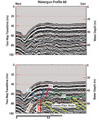 |
| Figure 13. Seismic-reflection profile showing possible fault within the Hudson Shelf Valley. |
|
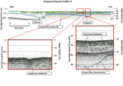 |
| Figure 12. Seismic-reflection profilee showing Coastal Plain Unconformity & overlying Quaternary deposits. Also link to larger image. |
|
A second major channel incises the coastal-plain strata in the
Hudson Shelf Valley area (Fig. 13), and
forms the oldest of a complex of at least three (possibly four)
smaller cut-and-fill channels (Fig. 14).
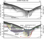 |
| Figure 14. Seismic-reflection profilee showing Pleistocene channels within Hudson Shelf Valley. Also link to larger image. |
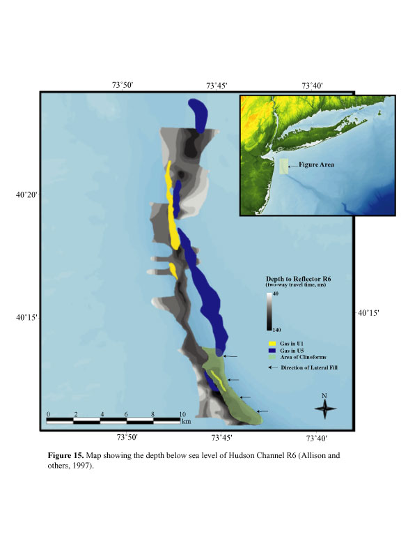
These smaller channels are informally designated as Hudson channels
R5, R6, and R7 (Figs. 6, 15,
and 16) with increasing depth in the
section (Lotto, 2000). Channel R7, and in places R6 and R5, incise
coastal-plain strata. The thalweg of Hudson channel R6 is marked by a series of saddles and depressions that closely follow the trend of the modern Hudson Shelf Valley
(Fig. 15). The surface of channel
R5 (Fig. 16) has been traced south of
the study area along the modern Hudson Shelf Valley to latitude 40º00' N (Allison and others, 1997).
 |
| Figure 15. Map showing depth of Hudson Channel R6 below sea level. Also link to larger image. |
An additional internal reflector, informally designated as reflector
R4 (Lotto , 2000), also has the geometric configuration of a shallow,
small incised channel in the area of Hudson Shelf Valley (Fig.
14). However, reflector R4 can be distinguished on CHIRP subbottom
profilees only in a small area due to its relatively low amplitude.
Due to its limited spatial extent, we have not interpreted reflector
R4 as a paleo-Hudson channel.
Pleistocene sedimentary deposits
that fill the smaller Hudson channels are informally designated
as Hudson Channel-Fill Units (CFUs) CFU5, CFU6, and CFU7 respectively
(Lotto, 2000). CFU7 is acoustically amorphous and difficult to
distinguish due to acoustic blanking from the overlying gassy
sediment of unit CFU5 (Fig. 14). CFU7
pinches out to the north. CFU6 (Fig. 14)
crops out as a narrow belt on the west wall of the modern Hudson
Shelf Valley from latitude 40º7'N to 40º10'N,(Allison and others,
1997). South of 40º15', clinoform strata of CFU6 fill the upper
part of channel R6 from the east (Fig.
15). Channel R5, the floor of which is conformable to the
bedding of CFU6 on
 |
| Figure 16. Map showing depth to Hudson channel R5 below sea level. Also link to larger image. |
its western flank and unconformable on its eastern
flank, has truncated much of CFU6. CFU5 is gas-charged sediment
(Fig. 14) and crops out in isolated
areas within the Hudson Shelf Valley from latitude 40º15'N to
40º18'N (Fig. 4). CFU5 exhibits westward-prograding
clinoform fill south of 40º14'N and eastward-prograding clinoform
fill north of the same latitude (Fig. 16).
Pleistocene Shelf Sedimentary
Deposit
The Pleistocene sedimentary
deposit is not restricted to the CFUs, but extends across much
of the study area (Fig. 8). The upper
section of the Pleistocene deposit is extensively incised by additional
cut-and-fill channels that trend generally north to south from
southern Long Island (Fig. 17). These
laterally discontinuous cut-and-fill channels are interpreted
to be glaciofluvial features (Lotto, 2000), similar to those described
immediately east of the study area along the inner continental
shelf (Foster and others, 1999; Schwab and others, 1999, 2000b).
 |
| Figure 17. Seismic-reflection profile showing Holocene ravinement surface. Also link to larger image. |
In the nearshore area off Long
Beach, sandy gravel and gravelly sand exposed on the seabed are
interpreted by Schwab and others (2000a) to be reworked Pleistocene
glaciofluvial sediments (Fig. 4). Sidescan-sonar
images in the area reveal a series of sharply defined, linear,
high-backscatter features, perpendicular or slightly oblique to
the shoreline (Fig. 2a). These backscatter
features are interpreted to represent a series of low-amplitude,
transverse bedforms, in which gravelly sand forms the high-backscatter
lineations and fine sand produces the low backscatter (Duane and
others, 1972; Schwab and others 1997a, 1997b, 2000). Where buried
by Holocene sediment, the upper surface of the Pleistocene sedimentary
deposit is truncated by a relatively horizontal regional unconformity,
known as the Holocene ravinement surface (Fig.
7).
To view files in PDF format, download free copy of Adobe Acrobat Reader www.adobe.com/products/acrobat/alternate.html.
|