| |  |  | | Lake Pontchartrain Atlas: | | | | | | | | | | | | | | | | | | | | | | | | | | | | | | | Environmental Issues |  | | | | | | | | | | | | | |  | | | | | | | | | | |  | Environmental Issues - Aggregate Dredge Holes Contributors: Connor, Jr., Maygarden, Penland, Kindinger - Lake Pontchartrain Dredge Pit Bathymetry
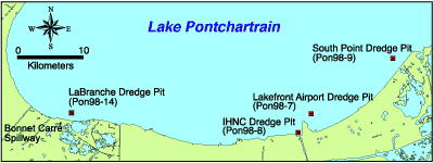 | | Figure 34: Lake Pontchartrain dredge pit locations. | In 1998, a partnership was formed between the UNOCRL and the USGS to collect hydrographic data along the south shore of Lake Pontchartrain in order to document bathymetric change since the early 1900's. These hydrographic data were processed and computer generated to produce bathymetric maps. Location of dredge- pits and specific study areas are shown in Figure 34. These bathymetric maps reflect two adjacent dredge holes located to the northeast of the Lakefront Airport runway (Figures 35, 36 and 37). The holes range in depth from 20 to 22 m (65.6-72.2 ft). Orleans Levee District documents show that this pit was excavated between 1977 and 1980, the material being used for an airport expansion project (Orleans Levee District communication). 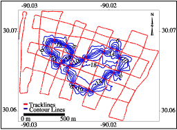 | | Figure 35: Trackline map with contour lines: Lakefront Airport dredge pit. | 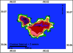 | | Figure 36: Lakefront Airport filled contour map. | 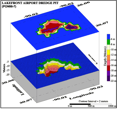 | | Figure 37: 3D bathymetric profile including filled contour map: Lakefront Airport dredge pit. | « Previous | Next » |
