| |  |  | | Lake Pontchartrain Atlas: | | | | | | | | | | | | | | | | | | | | | | | | | | | | | | | Environmental Issues |  | | | | | | | | | | | | | |  | | | | | | | | | | |  | Environmental Issues - Aggregate Dredge Holes Contributors: Connor, Jr., Maygarden, Penland, Kindinger - Lake Pontchartrain Dredge Pit Bathymetry
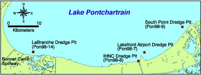 | | Figure 30: Lake Pontchartrain dredge pit locations. | In 1998, a partnership was formed between the University of New Orleans Coastal Research Laboratory and the U.S. Geological Survey to collect hydrographic data along the south shore of Lake Pontchartrain in order to document bathymetric change since the early 1900's. These hydrographic data were processed and computer-generated to produce the bathymetric maps shown. The bathymetry indicates that a complex of dredge holes exist in the vicinity of the Inner Harbor Navigation Canal (IHNC) and stretch west along the shoreline. These holes are the remains of dredge holes left during the construction of the Lakefront Land Reclamation Project, completed in 1930, as well as a 1961 project to expand the apron and runway of Lakefront Airport (Orleans Levee District communication). The dredge holes close to the IHNC range in depth from 12 to 16 meters (39.4 to 52.5 ft), this depth being maintained by natural scouring of tidal water. The more shallow portions along the shoreline have been filled in by natural re-working of bottom sediment. 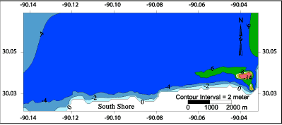 | | Figure 31: Trackline map with contour lines: IHNC dredge pit. | 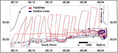 | | Figure 32: IHNC filled contour map. |  | | Figure 33: 3D bathymetric profile including filled contour map: IHNC dredge pit. | « Previous | Next » |
