| |  |  | | Lake Pontchartrain Atlas: | | | | | | | | | | | | | | | | | | | | | | | | | | | | | | | Environmental Issues |  | | | | | | | | | | | | | |  | | | | | | | | | | |  | Environmental Issues - Sediment Quality and Dispersal Contributors: Waters, Easley, Penland, Noakes Introduction 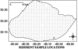 | | Figure 97: Sediment sample locations for XRF analysis in Lake Pontchartrain. | Lakebed sediment characterization was one of the primary tasks of the USGS Lake Pontchartrain study. To assist in this task, a rapid seafloor sediment-sampling and analysis system, developed by the Center for Applied Isotope Studies at the University of Georgia (CAIS), was employed during September 1996. In Lake Pontchartrain, 757 surface sediment samples were collected on a 1.2 km (0.75 mi) grid (Figure 97) and were analyzed by x-ray fluorescence spectroscopy (XRF) for bulk metals concentration. In the spring of 1997 the Bonnet Carré Spillway was opened on March 17 and closed on April 18. The maximum peak flow rate of 240,000 cfs (6,880 cms) was attained on March 27, 1997 and maintained through April 2, 1997. While the Spillway was open in 1997, approximately 11.8 km3 (2.8 mi3) of sediment-laden water entered Lake Pontchartrain, or slightly more than two times the volume of the lake (Turner et al., 1999). At seven sampling stations along the Lake Pontchartrain Causeway, the average total suspended sediment concentration peaked at approximately 70 mg/l during the Spillway opening and the total mass of sediment discharged into the Lake was approximately 7.1 x 10⁸ kg (780,000 US tons). As a result of these events, the USGS, the LPBF and the CAIS revisited the 757 locations that were sampled in 1996 and re-evaluated these sites using identical sampling and analytical methods. The 757 sediment samples collected by CAIS in 1996 (pre-Spillway) and 1997 (post-Spillway) were analyzed by XRF for the bulk concentration of 19 metals. Eight of these metals (silicon, aluminum, potassium, calcium, iron, magnesium, titanium, and sulfur) are structural components of various mineral phases and are generally considered "major cations". The remaining metals (copper, zinc, chromium, nickel, cadmium, antimony, tin, lead, strontium, zirconium, and barium) are usually present in low concentrations in sediments, as both naturally-occurring and anthropogenically-introduced constituents, and are traditionally referenced as "trace metals". The spatial distribution and variability of these chemical components were investigated through the use of traditional statistical methods, mapping, and geostatistical analysis. Variogram Fundamental to spatial analysis of the continuity of data is the development of the variogram, which is a measure of the degree of spatial dependence between samples. The variogram is simply the average difference in variance between points that are separated by some distance, delta h. For continuous data, if delta h is a small distance, the points being compared tend to be very similar and the value of the variogram is small. As the distance delta h is increased, the squared differences between points become larger until a distance is reached at which the points being compared are no longer spatially related and the value of the variogram becomes equal to the magnitude of the variance around the average value. Aluminum Aluminum is one of two major cations, sulfur is the other, that exhibits an increase in statistical variability in the post-Spillway samples relative to the preceding year (var. = 0.766 for 1996 and var. = 1.158 for 1997). Although sample variance is clearly greater in the 1997 data set, spatial variability is considerably lower in the post-Spillway sample set than in the 1996 data. Aluminum concentration contour lines are generally continuous and enclose broad areas of a single concentration interval in the 1997 data set while the contour lines in the 1996 data set are more discontinuous and generally enclose small, uneven areas of concentration intervals (Figures 98a and 98b). 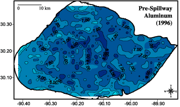 |  | 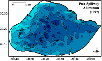 | | Figure 98: Aluminum concentration contours for a) (top) pre-spillway opening (1996) and b) (bottom) post-spillway opening (1997). | 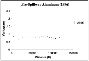 | 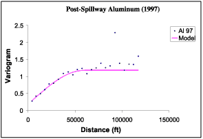 | | Figure 99: (top) Aluminum variogram for a) pre-spillway opening (1996) and b) (bottom) post-spillway opening (1997). | The aluminum variogram for the pre-Spillway sediments is essentially flat (spatially random) and individual values of the variogram cluster about the sample variance (var. = 0.766) (Figure 99a). The aluminum variogram for the post-Spillway sediments exhibits a high degree of spatial continuity and is modeled with a spherical variogram (Figure 99b). The variogram sill (1.0) is approximately equal to the sample variance (var. = 1.158) and the range is consistent with a modeled value of 60,000 feet (18,287 m) indicating that aluminum concentrations are spatially related to a distance of more than 10 miles (> 18 km). The 1997 (Figure 98b) map demonstrates that in addition to being spatially continuous, aluminum concentration contours delineate a clearly defined trend in the post-Spillway sediments; low aluminum concentrations are restricted to the margins of the Lake while high aluminum concentrations (> 7.0 wt%) occur only within a narrow zone in the center of the Lake. « Previous | Next » |
