| |  |  | | Lake Pontchartrain Atlas: | | | | | | | | | | | | | | | | | | | | | | | | | | | | | | | Environmental Issues |  | | | | | | | | | | | | | |  | | | | | | | | | | |  | Environmental Issues - Sediment Quality and Dispersal Contributors: Waters, Easley, Penland, Noakes Magnesium Relative to the other major cations, the descriptive statistics for post-Spillway magnesium concentrations exhibit the largest divergence from pre-Spillway values. The post-Spillway mean (0.96) is less than half of the pre-Spillway mean (1.89), and the variance in the 1997 sediments (var. = 0.138) is less than a quarter of the variance in the preceding year's samples (var. = 0.886). This difference is readily apparent in the 1996 concentration contour map, which is much darker than the post-Spillway map (Figure 103a and b). The 1996 map also shows that magnesium concentrations are greatest in the southeast quadrant of the Lake. Poirrier (1978) initially identified salinity stratification in this part of the Lake and attributed the increased bottom salinities to salt water intrusion from the MRGO via the IHNC. Researchers from the UNO Department of Engineering have recently measured bottom salinities in excess of 22 ppt. in the southeastern portion of the Lake. Although magnesium in Lake Pontchartrain sediments may occur as a minor constituent structurally bound in smectite, chlorite, or vermiculite clays, it occurs predominantly as a hydrated polar cation adsorbed onto the surface (exchange sites) of any of a number of fine-grained particles. Clay minerals in fresh water have their exchange sites occupied chiefly by calcium. When these clays encounter seawater, the calcium is replaced by sodium, potassium, and magnesium, and the net effect is to remove sodium, potassium, and magnesium from seawater and supply calcium to seawater. The much higher concentrations of magnesium in the pre-Spillway sediments are considered to represent adsorption of magnesium onto exchange sites in lakebed sediments due to exposure to more saline waters. 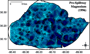 | 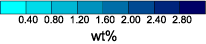 | 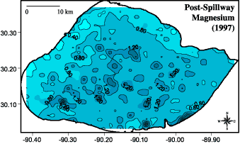 | | Figure 103a: Magnesium concentration contours for a) (top) pre-spillway opening (1996) and b) (bottom) post-spillway opening (1997). | Trace Metals Trace metal concentrations are quite low and the trace metal concentration contour maps are nominally more continuous for the post-Spillway sediments. Copper distributions are typical of most trace metals with areas of highest concentrations located adjacent to south shore discharge canals in the pre-Spillway sediments. Post-Spillway copper concentration contours are slightly less heterogeneous than the pre-Spillway samples (Figures 104a and b). Concentrated tin samples in the pre-Spillway data set are located adjacent to the mouth of Bayou Liberty, adjacent to the New Orleans Municipal Yacht Harbor (MYH), and in the vicinity of numerous oil and gas wells in the southwest portion of the Lake (Figure 105a). Tin was traditionally used as a biocide in antifouling paints used by the marine industry and the Liberty Bayou and MYH sites are historic marine construction and maintenance locations. Post-Spillway tin concentrations are less spatially and statistically variable than pre-Spillway samples (Figures 105b).  |  | 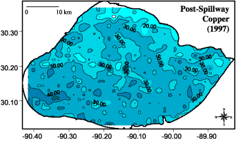 | | Figure 104a: Copper concentration contours for a) (top) pre-spillway opening (1996) and b) (bottom) post-spillway opening (1997). | 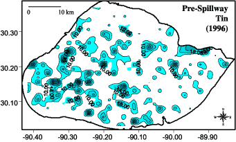 |  | 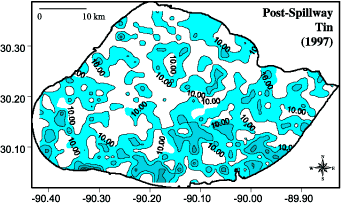 | | Figure 105a: Tin concentration contours for a) (top) pre-spillway opening (1996) and b) (bottom) post-spillway opening (1997). White areas on the map denote sample locations where tin concentrations are below the XRF detection limits. | « Previous | Next » |
