| |  |  | | Lake Pontchartrain Atlas: | | | | | | | | | | | | | | | | | | | | | | | | | | | | | | | Environmental Issues |  | | | | | | | | | | | | | |  | | | | | | | | | | |  | Environmental Issues - Sediment Quality and Dispersal Contributors: Waters, Easley, Penland, Noakes Silicon The concentration contour maps and variograms for silicon demonstrate a significant difference in spatial variability between pre-and post-Spillway sediments (Figures 100a and b and 101a and b). Silicon concentrations are notably less heterogeneous in the post-Spillway sediments than in the sediments from the preceding year. The variograms for the two sample sets confirm the differences in spatial variability. The variogram for the 1996 data set exhibits random behavior with individual variogram values clustered about the sample variance (var. = 1.774), while the data from the post-Spillway samples conform to a spherical model with the sill (1.6) approaching the sample variance (var. = 1.727) at a range of 18,287 m (60,000 ft). The 1997 contour map shows that silicon concentrations in the post-Spillway sediments demonstrate a trend that is inverse to that of aluminum, with high silicon concentrations restricted to the periphery of Lake Pontchartrain while low silicon values dominate the central portion of the Lake. 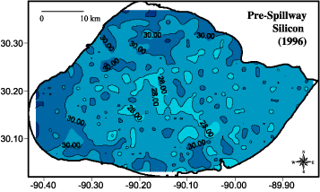 | 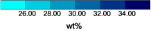 | 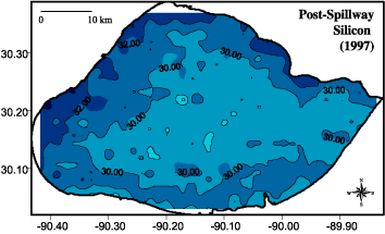 | | Figure 100: Silicon concentration contours for a) (top) pre-spillway opening (1996) and b) (bottom) post-spillway opening (1997). |  | 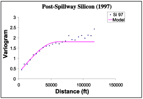 | | Figure 101: Silicon variogram for a) (top) pre-spillway opening (1996) and b) (bottom) post-spillway opening (1997). | Quartile Maps The elemental concentration contour maps and geostatistical analysis clearly suggest that the Spillway opening produced a marked change in the spatial variability of aluminum and silicon concentrations following the discharge event relative to the antecedent conditions. The silicon and aluminum quartile concentration maps demonstrate that silicon, a surrogate for the silt fraction, is concentrated along the periphery of the lake, while aluminum, a proxy for the fine-grained clay fraction, is concentrated in the central portion of the lake (Figures 102 a and b). The predominant wind during the summer in southern Louisiana is from the southeast creating a two-gyre circulation pattern in Lake Pontchartrain (Signell and List, 2000; Haralampides et al., 2000) (see Processes of Lake Pontchartrain Circulation section). According to the circulation model, the strongest currents exists along the shoreline with a return flow current in the center of the Lake. The sediment distribution patterns suggested by the quartile concentration maps are consistent with the two gyre circulation model. Silicon (silt) is concentrated along the periphery of the Lake, especially the western and northern borders. The high concentrations in these regions are considered to reflect proximity to the Bonnet Carré Spillway in the southwest corner of the Lake. Although silicon concentrations are lower in the southern and southeastern portions of the Lake, most samples in these regions fall in the 50-75% quartile. Aluminum (clay) is concentrated in the center of the Lake and greatly diminishes along the periphery where wind-generated currents are strongest. The bimodal spatial distribution of the 75-100% aluminum quartile suggests clay deposition in the center of two circulation cells. The variogram model range of 18,287 m (60,000 ft) for both silicon and aluminum is consistent with a circulation gyre radius of approximately 16.1 km (10 mi). The lack of similar distribution patterns for pre-Spillway sediment samples is considered to reflect sediment mixing due to divergent wind patterns from winter frontal passages and due to tidal currents. The strong spatial continuity of the 1997 data reflects sample collection immediately following a single depositional event. 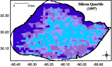 |  | 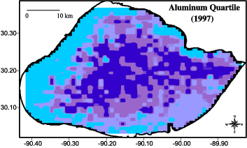 | | Figure 102: Quartile concentration contour maps of a) (top) Silicon and b) (bottom) aluminum. | « Previous | Next » |
