| |  |  | | Lake Pontchartrain Atlas: | | | | | | | | | | | | | | | | | | | | | | | | | | | | | | | Environmental Issues |  | | | | | | | | | | | | | |  | | | | | | | | | | |  | Environmental Issues - Water Quality Contributors: Abadie, Poirrier Effects of Shell Dredging on Water Clarity and Clam Abundance  | | Figure 85: Twelve month moving averages of monthly Secchi disk transparency readings at three causeway sampling sites (North Shore, Mid-Lake and South Shore) from 1986 through 1995. Adapted from Francis and Poirrier, 1999. | From 1933 to 1990 Rangia cuneata clam shells were harvested in Lake Pontchartrain. According to 1980's estimates, these shells had a gross annual value of $34 million and were used for the construction of roadways, parking lots, and levees and in the production of cement ( USACE , 1987). Forty-four percent of the Lake was opened to shell dredging. Dredging operations were prohibited around the shoreline, bridges and gas pipelines. Shell dredgers used a large suction device to draw up shells, sediment and water, creating trenches 1.5-2 m wide and 0.5-1 m deep. The shells were removed and the sediment and water were discharged back into the Lake ( USACE , 1987). This slurry produced a localized increase in turbidity. Despite the economic value of the shell mining industry, dredging in Lake Pontchartrain was banned in an effort to improve water quality. Secchi disk transparency and the density and distribution of clams prior to shell dredging are unknown. Only portions of the Lake were open to shell dredging and only 1% of the total area of the Lake was affected at any given time, therefore, it was thought that shell dredging did not have a widespread or significant impact on the Lake. Since baseline studies were not done before shell dredging began, the impacts were difficult to determine. However, studies on the benthic community in Lake Pontchartrain conducted in the 1950's, 70's and 80's appeared to show a downward trend in the abundance of large (> 20 mm), sexually mature, Rangia cuneata with time (Suttkus et al.,1954, Tarver and Dugas, 1973, Sikora and Sikora, 1982, Poirrier et al ,1984). Only since the cessation of shell dredging in 1990 have the effects of over fifty years of dredging been realized. Secchi Disk Transparency According to historic monthly averages from three sites along the Causeway Bridge, at a north shore, a mid-lake and a south shore site, there has been a major difference in transparency since 1990. Approximately the same secchi disk (a disk, divided into black and white quarters, used to gauge water clarity by measuring the depth at which it is no longer visible from the surface) transparency was seen at all three sites from 1986 through 1990 (Figure 85). However, from 1991 to 1995, significant increases in transparency occurred at the north shore and mid-lake sampling sites, but not at the south shore site. Wind speed and salinity were approximately the same for both time periods and the differences in Secchi disk transparency were attributed to the cessation of shell dredging (Francis and Poirrier, 1999). 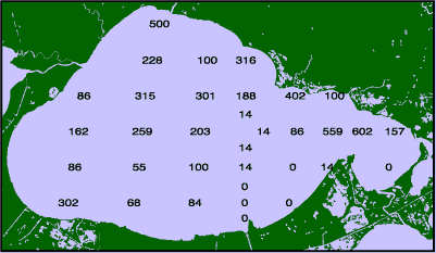 | | Figure 86: Map of Lake Pontchartrain. The average density of large Rangia Cuneata per square meter are indicated at each site. | Rangia Cuneata Density 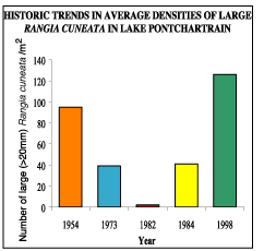 | | Figure 87: Historic average densities of large Rangia cuneata in Lake Pontchartrain. A one-way anova and means comparison were used to assess the effect of year on the historical densities. Clam densities from 1954 and 1998 were significantly different from 1973, 1982 and 1984 lake wide densities at the 0.05 level. | Forty-four sites were sampled in Lake Pontchartrain in 1996 and 1997 to determine the density of Rangia in the estuary in the absence of shell dredging. The number of large (> 20 mm) clams per square meter at each site is shown on the map. The average density of large Rangia from Lake Pontchartrain was 126 per square meter. Large clam densities from this study were significantly different from 1973, 1982 and 1984 studies but not from the 1954 study indicating recovery. The best explanation for the increased density of large Rangia is the cessation of shell dredging (Abadie and Poirrier, 2000). Rangia clams play a vital role in the Pontchartrain estuary. As a filter feeder, Rangia clams may remove pathogens and fecal coliform bacteria, helping to make the lake suitable for swimming. The average density of all sizes of Rangia is about 400 per square meter. Based on these densities we have estimated that Rangia clams can filter a volume equivalent to the volume of Lake Pontchartrain every four days. Clams also produce over one million tons of shells per year in Lake Pontchartrain, which is converting soft unstable bottoms to productive fisheries habitat. In addition, Rangia clams provide a food source for blue crabs, many fish species, shrimp and waterfowl. Due to its abundance, importance in the food chain and ability to regulate environmental conditions, Rangia should be regarded as a keystone species that supports critical ecological processes that must be maintained. « Previous | Next » |
