| |  |  | | Lake Pontchartrain Atlas: | | | | | | | | | | | | | | | | | | | | | | | | | | | | | | | Environmental Issues |  | | | | | | | | | | | | | |  | | | | | | | | | | |  | Environmental Issues - Water Quality Contributors: McCorquodale, Georgiou, Haralampides The results from a survey using an Acoustic Doppler Current Profiler (ADCP) on August 28, 1997 at the IHNC are shown in Figure 66. The image shows velocity vectors broken into north (Lake Pontchartrain) and south (IHNC) components for the entire depth of the channel. It is evident that the flow exchange between the IHNC and Lake Pontchartrain is two-way in that the surface currents are, for the most part, different than the bottom currents. The current data suggest that as the lower density water is leaving the Lake, higher density water from the IHNC is entering the Lake as an underflow. This system produces two-way flow at the Lake-canal interface. In addition, this higher density water is often responsible for salt water intrusion in Lake Pontchartrain. A time series of temperature, bottom dissolved oxygen and salinity differences from a near fieldpoint of the salt water plume near the IHNC is shown in Figure 67. The persistent high temperatures during the summer along with the high vertical salinity gradients originating from the IHNC produce extremely low oxygen conditions in the bottom waters of Lake Pontchartrain. During the winter, strong salinity gradients were noted, but no hypoxia was observed. 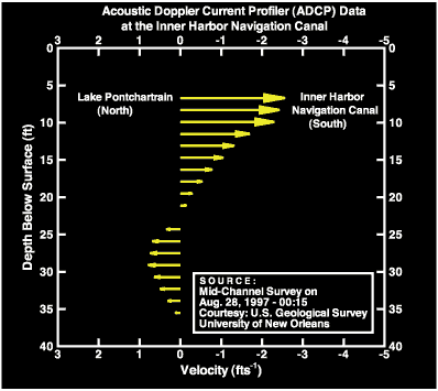 | | Figure 66: Velocity profile showing the strength and direction flow at depth in the IHNC. | 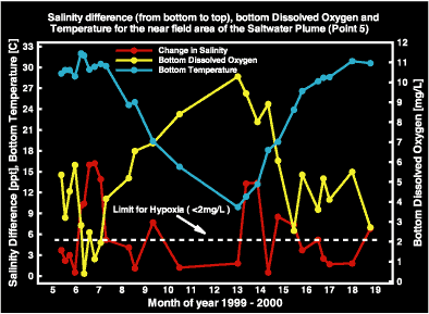 | | Figure 67: Salinity differences, bottom temperature and bottom dissolved oxygen data for an area around the saltwater plume near the IHNC from May 1999 - June 2000. | « Previous | Next » |
