| |  |  | | Lake Pontchartrain Atlas: | | | | | | | | | | | | | | | | | | | | | | | | | | | | | | | Environmental Issues |  | | | | | | | | | | | | | |  | | | | | | | | | | |  | Environmental Issues - Water Quality Contributors: Georgiou, McCorquodale The IHNC is connected to the MRGO, providing a means for ships to navigate from the Gulf of Mexico close to Lake Pontchartrain and the Mississippi River at New Orleans. The IHNC brings high salinity water into Lake Pontchartrain. Under certain conditions, this higher density water has been observed to form a layer of high salinity water over a large area of the Lake's bottom (259.2 km2, 100 mi2). This layer is often associated with low dissolved oxygen (Figure 63) and at times becomes hypoxic, a condition that is harmful to shellfish. In addition, the continuous introduction of high salinity water entering the Lake contributes to the rise in the Lake's average salinities and is also a threat to neighboring marshes. 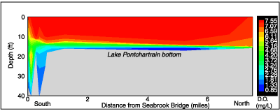 | | Figure 63: Dissolved oxygen stratification profile of Lake Pontchartrain in the vicinity of IHNC. | Sampling along a radial path starting in the IHNC and proceeding into Lake Pontchartrain has been in effect since the summer of 1998. This effort includes data collection throughout the water column for salinity, dissolved oxygen and temperature at 12 stations in the vicinity of the IHNC to the south and Lake Pontchartrain. Figures 63 and 64 show a longitudinal profile of salinity and dissolved oxygen starting in the IHNC and ending in Lake Pontchartrain. This profile was typical of the conditions observed for the summer of 1999. Figure 65 shows a plan view of the extension of the bottom salinity plume and the area of impact. 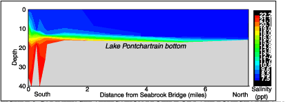 | | Figure 64: Salinity stratification profile of Lake Pontchartrain in the vicinity of IHNC. | The stratified zone was approximately 0.5 m (1.6 ft) deep, up to 259.2 km2 (100 mi2) in area. The summer observations usually showed hypoxia within the stratified layer but no hypoxia outside of this layer. More recent data during winter months show high stratification with respect to salinity, but little or no hypoxia. It is thought that the dominant winds out of the north, northwest and northeast in the winter cause greater vertical mixing at the plume zone and thus result in an increase in the bottom dissolved oxygen (DO). The low winter water temperatures also result in high saturation values for the DO. In the summer there are more southerly winds which have a short fetch with respect to the plume location, and therefore result in smaller waves and less vertical mixing. Another contributing factor in the salinity plume formation in 1998 and 1999 was the drought condition over the Lake Pontchartrain watershed.  | | Figure 65: Plan view of lake floor salinity values near IHNC. | « Previous | Next » |
