USGS Home - www.usgs.gov
Coastal and Marine Geology Program
Coastal & Marine Geology Program > Center for Coastal & Regional Marine Studies > Environmental Atlas of Lake Pontchartrain

Environmental Atlas of the Lake Pontchartrain Basin

Lake Pontchartrain Atlas Home
Lake Pontchartrain Atlas:
Preface
Table of Contents
Introduction
Environmental Overview
Environmental Status & Trends
Restoration
Physical Environments You are at the Physical Environments section of the Environmental Atlas of Lake Pontchartrain
Basin Geology
Biological Resources
Environmental Issues
Bibliography
Resources
Contributors
Acronyms
Contact:
Jack Kindinger
Physical Environments: Climate | Hurricane History | Circulation | Wave Climate | Relative Sea Level | Relative Sea Level Rise

Physical Environments - Climate

Contributors: Peters, Beall

Map showing thw location of New Orleans. New Orleans Climate Records:

Record High: 39°C (102°F) August 22, 1980

Record Low: -12°C (11°F) December 23, 1989

Record Monthly Precipitation: 53.79 cm (21.18 in) May 1995

Figure 1: Record high and low temperatures and record monthly precipitation for the New Orleans area.

Graph showing the average monthly high and low temperatures (°F) for the New Orleans area for the years 1954-2000.
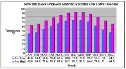
Figure 2: Average monthly high and low temperatures (°F) for the New Orleans area for the years 1954-2000.

Graph showing the average monthly precipitation and number of rain days for the New Orleans area for the years 1954-2000.
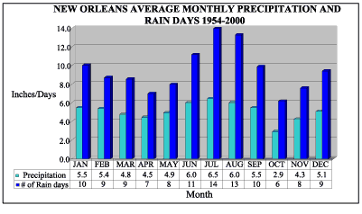
Figure 3: Average monthly precipitation and number of rain days for the New Orleans area for the years 1954-2000.

Vectors on a wind rose indicate the frequency of occurrence with wind coming from a given direction.
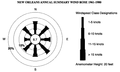
Figure 4: Rose diagram for the New Orleans area for the years 1961-1980. Vectors on a wind rose indicate the frequency of occurrence with wind coming from a given direction. The length of a vector reflects total percentage of hours with winds from a certain direction. Center circle represents the frequency of a "calm" wind. Concentric circles extending outward from center represent a five-percent increase.

Source and Acknowledgement: Historical climate data were provided by the Southern Regional Climate Center, Baton Rouge. Their contribution and cooperation in the project is greatly appreciated.

« Previous | Next »


Coastal & Marine Geology Program > Center for Coastal & Regional Marine Studies > Environmental Atlas of Lake Pontchartrain

FirstGov.govemail Feedback [an error occurred while processing this directive]