USGS Home - www.usgs.gov
Coastal and Marine Geology Program
Coastal & Marine Geology Program > Center for Coastal & Regional Marine Studies > Environmental Atlas of Lake Pontchartrain

Environmental Atlas of the Lake Pontchartrain Basin

Lake Pontchartrain Atlas Home
Lake Pontchartrain Atlas:
Preface
Table of Contents
Introduction
Environmental Overview
Environmental Status & Trends
Restoration
Physical Environments You are at the Physical Environments section of the Environmental Atlas of Lake Pontchartrain
Basin Geology
Biological Resources
Environmental Issues
Bibliography
Resources
Contributors
Acronyms
Contact:
Jack Kindinger
Physical Environments: Climate | Hurricane History | Circulation | Wave Climate | Relative Sea Level | Relative Sea Level Rise

Physical Environments - Climate

Contributors: Peters, Beall

Map showing the location of Plaquemines. Plaquemines Climate Records:

Record High: 38°C (100°F) July 10, 2000

Record Low: -11°C (12°F) December 23, 1989

Record Monthly Precipitation: 50.8 cm (20 in) March 1991

Figure 15: Record high and low temperatures and record monthly precipitation for the Plaquemines area.

Graph showing the average monthly high and low temperatures (°F) for the Plaquemines area for the years 1960-2000.
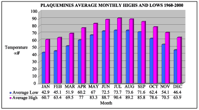
Figure 16: Average monthly high and low temperatures (°F) for the Plaquemines area for the years 1960-2000.

Graph showing the average monthly precipitation and number of rain days for the Plaquemines area for the years 1960-2000.
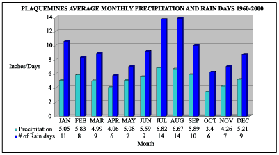
Figure 17: Average monthly precipitation and number of rain days for the Plaquemines area for the years 1960-2000.

Source and acknowledgement: Historical climate data were provided by the Southern Regional Climate Center, Baton Rouge. Their contribution and cooperation in this project is greatly appreciated.

« Previous | Next »


Coastal & Marine Geology Program > Center for Coastal & Regional Marine Studies > Environmental Atlas of Lake Pontchartrain

FirstGov.govemail Feedback [an error occurred while processing this directive]