| ![](../images/dot_clear.gif) | ![](../images/669corner-ul.gif) | Lake Pontchartrain Atlas: | | ![](../images/dot_clear.gif) | | ![](../images/dot_clear.gif) | | ![](../images/dot_clear.gif) | | ![](../images/dot_clear.gif) | | ![](../images/dot_clear.gif) | | ![](../images/dot_clear.gif) | | ![](../images/dot_clear.gif) | Physical Environments | ![You are at the Physical Environments section of the Environmental Atlas of Lake Pontchartrain](../images/pointer.gif) | | ![](../images/dot_clear.gif) | | ![](../images/dot_clear.gif) | | ![](../images/dot_clear.gif) | | ![](../images/dot_clear.gif) | | ![](../images/dot_clear.gif) | | ![](../images/dot_clear.gif) | | ![](../images/dot_clear.gif) | ![](../images/dot_clear.gif) | | ![](../images/669corner-ll.gif) | | ![](../images/dot_clear.gif) | | ![](../images/dot_clear.gif) | ![](../images/dot_clear.gif) | ![](../images/dot_clear.gif) | | | ![](../images/spacer.gif) | Physical Environments - Climate Contributors: Peters, Beall ![Map showing location of Covington.](images/pg31fig1.gif) | 
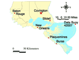
Covington Climate Records: Record High: 40°C (104°F) July 7, 2000 Record Low: -14°C (7°F) January 21, 1985 Record Monthly Precipitation: 48.87 cm (19.24 in) March 1947 | Figure 9: Record high and low temperatures and record monthly precipitation for the Covington area. | ![Graph showing the average monthly high and low temperatures (°F) for the Covington area for the years 1930-2000.](images/pg31fig2.gif) | 
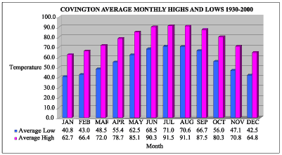
Figure 10: Average monthly high and low temperatures (°F) for the Covington area for the years 1930-2000. | ![Graph showing the average monthly precipitation and number of rain days for the Covington area for the years 1930-2000.](images/pg31fig3.gif) | 
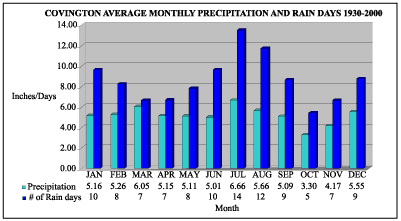
Figure 11: Average monthly precipitation and number of rain days for the Covington area for the years 1930-2000. | Source and acknowledgement: Historical climate data were provided by the Southern Regional Climate Center, Baton Rouge. Their contribution and cooperation in this project is greatly appreciated. « Previous | Next » |