Title Page
Introduction
Methods
Results
DISCUSSION
Conclusion
Acknowledgments
Conclusions
Acknowledgements
References
|
DISCUSSION
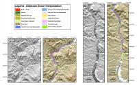 |
| Figure 3. Click on figure for larger image. |
The geophysical profile data (having 10 cm vertical resolution) indicate that remarkably little sediment has accumulated in Lake Mohave since impoundment in 1953. This lack of sediment is in striking contrast to Lake Mead which accumulated as much as 30 m of sediment immediately behind the Hoover Dam in the first 15 years of its history (Gould, 1951; Twichell and others, 1999). The marked contrast between the two lakes is undoubtedly due to Lake Mohave being 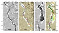 |
| Figure 4. Click on figure for larger image. |
downstream and younger than Lake Mead. Virtually all of the sediment transported by the Colorado River has been trapped in Lake Mead or in other upstream reservoirs. With the amount of sediment supplied by the Colorado River being minimal, Lake Mohave provides an opportunity to assess the volume and style of sediment input from other sources.The sidescan sonar imagery also shows little post-impoundment sediment in the lake. The preservation of networks of small channels on the surface of alluvial deposits, sand waves on the floor of the drowned Colorado River, and roads crossing alluvial fans all indicate minimal sedimentation since impoundment. Otherwise these features would have been buried 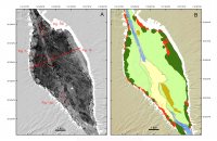 |
| Figure 5. Click on figure for larger image. |
too deeply to be imaged by the high-frequency sidescan system. Similar features are also preserved on the floor of the John Day reservoir on the Columbia River where video observations show that only 1-3 cm of fine-grained sediment mantle the original floor of the reservoir (Cross and Twichell, 2004). The interpretation of the sidescan sonar imagery is also validated by a comparison with 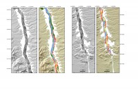 |
| Figure 6. Click on figure for larger image. |
major geomorphic features observed on a 1938 aerial photographic mosaic (Colorado River Commission of Arizona, unpublished data shown in fig. 13a-c). Fluvial channel banks (fig. 13b) are clearly seen in both the aerial photography (fig. 13a) and the sidescan sonar imagery (fig. 13c). Roads are also observed in both images where a ferry once crossed the Colorado River (fig. 13). Aerial photography was compared to the sidescan imagery to resolve if the fan and mass-wasting deposits observed along the margins of the reservoir where deposited after impoundment. However, the comparison was inconclusive, partly because the aerial photography was of, low resolution and not yet properly 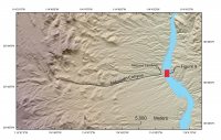 |
| Figure 8. Click on figure for larger image. |
geo-referenced. A detailed comparison awaits a careful registration of the two sets of imagery with each other.Approximately 96% of the floor of the reservoir is free of post-impoundment sediment. Two types of newly deposited sediment are observed in the remaining areas. One type has a low-backscatter surface on the sidescan imagery. These areas tend to occur in the deepest parts of 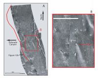 |
| Figure 9. Click on figure for larger image. |
the lake in sheltered areas along the edges of the drowned Colorado River channel. They cover approximately 2,304,000 m2, account for about 3% of the area surveyed, and occur in patches along the entire length of the lake. No samples are available, but the low-backscatter signature suggests that these are deposits of fine-grained sediment. The second type has a high-backscatter surface and commonly contains very high-backscatter targets. In one case, off Eldorado Canyon (fig. 8, fig. 9, and fig. 12b), the deposit is the result of a debris flow that moved through the wash in response to a flash flood (Glancy and Harmsen, 1975). Of the 31 mass-wasting deposits that were identified, 25 occur off the mouths of washes (fig. 3, fig. 4, fig. 5, fig. 6). Presumably these deposits are all associated with flash 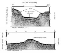 |
| Figure 12. Click on figure for larger image. |
floods in these washes. The other 6 mass-wasting deposits occur along the base of steep cliffs in the northern section of the lake, and appear to be the result of cliff collapse. The mass-wasting deposits cover approximately 341,000 m2, and account for about 0.5% of the lake's area. Because Lake Mohave contains minimal amounts of post-impoundment sediment it presents an opportunity to study the type and magnitude of local processes acting on these reservoirs. Clearly debris delivered to the lake by flash floods is a 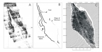 |
| Figure. 13. Click on figure for larger image. |
major agent for transporting coarse-grained material to the lake. The impact of these floods is indicated by the presence of automobiles on the surface of the debris flow deposit off Nelson's Landing (fig. 9). Several other washes appear to have similar deposits off their mouths which suggests that active transport of sediment by flash floods may be more common than previously anticipated and may be a potential hazard in more washes than had been identified by on-land surveys (Glancy and Harmsen, 1975; Moosburner, 1979; 1981). The significance of these flood events awaits a detailed comparison of the sidescan sonar image with pre-dam aerial photographs.
|
