USGS Open-File Report 2005-1231
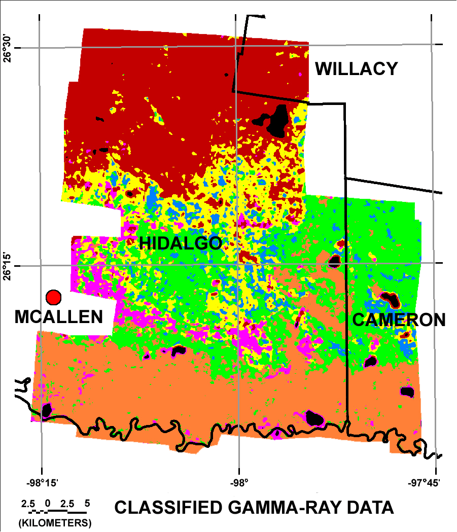
The aerial gamma-ray data reflect differences in the geologic materials that can be related to mapped geologic units. The twenty-one classes identified in the classification calculations do not, however, provide a unique signature for most of the mapped geologic units (refer to the discussion of geology comparisons). Groups of classes do show strong relationships to some of the geologic units. The groups of classes interpreted to reflect the geology were merged to produce the map shown in figure C1. Merged classes are denoted as M01, M02, etc. Click here to open the map legend in a separate window.
Most of the areas originally assigned to classes R19 and R20 are areas where the survey aircraft flew at altitudes greater than 200 m (see the map showing the areas of high flight altitudes). For that reason most of class M01 (magenta, refer to map legend) is considered to be an artifact of the survey. Class M02 (black, refer to map legend) is interpreted as indicative of the presence of water.
Merged class M03 (green, refer to map legend) on the map in figure C1 is the result of merging classes R01, R03, R06, R08 and R11 and is interpreted to indicate the presence of members of the Beaumont Formation. Figure C2 shows the revised classification map with the members of the Beaumont Formation (from the geologic map) shown as a red overlay.
Class M04 (yellow, refer to map legend) is identical to class R05. Figure C3 shows the revised classification map with the dune sand (Qds) shown as a red overlay. The geology comparison indicates that this class is frequently associated with areas mapped as dune sand (unit Qds) but large areas mapped as Qds (refer to figure C3) are outside the areas where M04 occurs. This may be an indication that some of the dune sands are sufficiently different that the radiometric signatures are different. Another possibility is that the aeolian sands are distributed over areas not shown on the geologic map. Because gamma rays are strongly absorbed by rocks, soil, and water, a thickness of dune sands of 20 cm or more (refer to Duval, Cook, and Adams, 1971) would mask the radiometric characteristics of any underlying materials. Figure C4 shows the revised classification map with the Lissie Formation (Ql) shown as a red overlay. Class M04 is only weakly associated with areas mapped as Lissie Formation but the geographic relationships suggest that class M04 may be a relatively good indicator of the presence of the LIssie Formation or of materials derived from it.
Class M05 (blue, refer to map legend) is identical to class R13. M05 occurs frequently in areas mapped as dune sand (unit Qds) (refer to geologic map and the geology comparisons). Although 59 percent (see Figure 7, geology comparisons) of this class occurs in areas mapped as dune sand, it only accounts for about 15 percent of the areas mapped as Qds (refer to figure C3). The gamma-ray data do not, for the most part, reflect the presence of aeolian sand dunes. Because aeolian processes tend to remove fine grained materials and leave behind larger pebbles and rocks (Bagnold, 1937), aeolian sand dunes can be expected to have different radiometric characteristics compared to local sediments if the sources of the sand are distal. The fact that the sand dunes are not distinct from the surrounding materials in this area suggests that the sand is locally derived.
Class M06 (dark red, refer to map legend) combines classes R04, R14, R16, and R17 and is largely associated with areas mapped as Goliad Formation. Figure C5 shows the revised classification map with the Goliad Formation (Tg) shown as a red overlay. Large areas of M06 also occur in areas mapped as dune sand (see figure C3). Because the signature for M05 is quite distinct (refer to the table of mean values), any wind blown materials are almost certainly materials derived from the Goliad Formation.
Class M07 (orange, refer to map legend) combines classes R02, R07, R09, R10 and R18 and is almost exclusively associated with areas mapped as Holocene floodplain deposits (Qas and Qam). Figure C6 shows the revised classification map with the floodplain deposits shown as a red overlay.
The overall result of this study is that the geologic map and the gamma-ray data exhibit some agreement but also disagree. Some of the areas of disagreement might be explained by an apparent inability of the maximum likelihood classifier to discriminate materials with similar radiometric characteristics. Other areas such as parts of M06 mapped as dune sand suggest that the geologic map may be incorrect or that the resolution of the geologic map may not be adequate for the purposes of this study. These data provide reasonably strong evidence that the contact between the Lissie and Goliad Formations should be revised.
![]() Comparison Histograms | Interpret Statistical Graphs
Comparison Histograms | Interpret Statistical Graphs ![]()

![]() U.S. Department of the Interior |
U.S. Geological Survey
U.S. Department of the Interior |
U.S. Geological Survey
URL: http://pubsdata.usgs.gov/pubs/of/2005/1231/conclusions.htm
Page Contact Information: Stephen Snyder
Page Last Modified: Saturday, 12-Jan-2013 21:27:47 EST