|
|
Methods
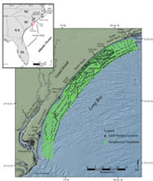 |
Figure 1. Location map of the study area showing geophysical tracklines and surficial grab sample locations.
Click on figure for larger image and full caption.
|
|
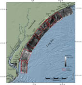
Figure 4. Sidescan-sonar image of the study area and figure locations.
Click on figure for larger image and full caption.
|
In 1999, the USGS began an offshore geophysical mapping program between Little River Inlet and Winyah Bay (fig. 1). The study area covers 700 km2 of the inner continental shelf from the seaward limit of breaking waves to ~10 km offshore. Six geophysical surveys were conducted over a five year period (1999 - 2003): October-November, 1999 aboard the R/V Atlantic Surveyor (Hill and others, 2000a, 2000b; Roberts and others, 2002); March 2000 aboard the R/V Megan Miller (Dadisman and others, 2001a, 2001b); June 2002 aboard the R/V Atlantic Surveyor; May 2001, 2002, and 2003 aboard the R/V Coastal II.
Geophysical data were acquired using a 100-105 kHz chirp sidescan-sonar system, a 2-7 kHz chirp sub-bottom profiler, a 300 Hz - 3 kHz boomer sub-bottom profiler, and a 234-kHz interferometric sonar during the offshore surveys aboard the R/V Atlantic Surveyor and the R/V Megan Miller. During the nearshore surveys aboard the R/V Coastal II, geophysical data were acquired using a 100/500 kHz dual-frequency sidescan-sonar system, a 500 Hz - 12 kHz chirp sub-bottom profiler, and a 234-kHz interferometric sonar. A full description of data acquisition and processing routines applied to the sub-bottom data is presented in Baldwin and others (2004).
Sidescan-sonar data were acquired at a 0.125-s sample rate, yielding a 400-m swath width. Data were digitally recorded at a 2 kHz sample rate, yielding ~0.2 m pixel resolution following the methodology of Danforth and others (1991). Data were further processed and digitally mosiacked based on procedures described in Paskevich (1992) and Danforth (1997). The composite sidescan-sonar mosaic was generated at a 4m/pixel resolution and exported from the processing software as a georeferenced Tagged Image File Format (TIFF), and incorporated into a Geographic Information System (GIS).
Swath bathymetric data were acquired with a 234-kHz interferometric sonar at a 0.133-s ping rate and digitally logged at a 2 kHz sample rate. The swath width of the interferometric sonar varied as a function of depth but generally achieved 7 - 10 times water depth, or 50 - 150 meters. A Motion Reference Unit (MRU) mounted directly above the sonar head recorded vessel motion (pitch, heave, roll, and yaw); attitude information was used to rectify bathymetric soundings. Additionally, a Sound Velocity Profiler (SVP) was used during nearshore surveys to measure the speed of sound in the water column. The sound-velocity structure is needed in order to accurately model the ray path to correct for refraction. Because an SVP was not available for use during offshore surveys, thus an average sound velocity of 1490 m/s was used. Vertical resolution for all surveys is approximately 1% of water depth. Bathymetric data were rectified for tidal fluctuations based on the ADCIRC circulation model (see http://www.marine.unc.edu/C_CATS/adcirc/adcirc.htm) and referenced to Mean Lower Low Water. Data were further processed using multibeam processing software developed at the University of New Brunswick (see http://gge.unb.ca/Personnel/Personnel.html). Fully processed bathymetric data were gridded at a 100 meter cell size and incorporated into a GIS.
Surface grab samples were collected by Coastal Carolina University using a Shipek grab sampler during the 2000 - 2002 field seasons (fig. 1). Locations were chosen based on variations in backscatter patterns observed in the sidescan-sonar mosaic (fig. 4). A total of 722 grab samples were collected during three cruises aboard the NOAA Ferrel (2000 and 2001) and Nancy Foster (2002) (Appendix A). Grain-size analyses for samples collected in 2000 were conducted by the USGS following the methodology of Poppe and others (1985). Surface samples collected in 2001 and 2002 were analyzed at Coastal Carolina University following a similar methodology.
Ship position for all surveys was determined through use of Differential Global Positioning System (DGPS) navigation. Slant-range position of the sidescan-sonar towfish was acquired through use of an acoustic ranging unit. Ship position, towfish altitude, and slant-range position are used to triangulate towfish layback (i.e., straight-line distance behind the vessel). Towfish position is assumed to be ± 5 m. The interferometric sonar was deployed on a rigid side-mount during all surveys. Offsets between the sonar head and the DGPS antenna were measured and the horizontal accuracy of bathymetric data is within ± 1 - 2 m. Grab sample locations were navigated through use of DGPS and are accurate to ± 1 - 2 m.
Shore-parallel survey tracklines were spaced 300 m apart to ensure overlap of adjacent sidescan-sonar swaths and complete coverage of the sea floor. The swath width of the interferometric sonar ranged from ~50 - 150 meters; thus only partial bathymetric coverage of the sea floor was achieved. In order to generate a bathymetric grid that accurately represents the regional sea-floor morphology, interpolation routines were used to fill data gaps between tracklines. All data were imported to a GIS for ease of display, analysis and interpretation.
|

 Back to Previous Section
 Forward to Next Section