|
|
Introduction
Regional Geologic Setting
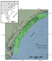 |
Figure 1. Location map of the study area showing geophysical tracklines and surficial grab sample locations.
Click on figure for larger image and full caption.
|
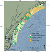 |
Figure 2. Surficial geologic map of the study area based on Baldwin and others (2004).
Click on figure for larger image and full caption.
|
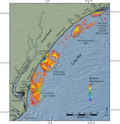 |
Figure 3. Map showing the thickness of modern sediment within the study area. Click on figure for larger image and full caption.
|
The Grand Strand region lies along the southern flank of the Mid-Carolina Platform High or Cape Fear Arch, the central axis of a structural high (Carolina Platform) that underlies portions of the Mid-Atlantic and Georgia Bight (Klitgord and others, 1988; Riggs and Belknap, 1988; Riggs and others, 1985; see figure 2 in Baldwin and others, 2006) (fig. 1). The Mid-Carolina Platform High is an upward doming, subsurface feature that extends from Cape Lookout, N.C. to Cape Romaine, S.C. and positioning along its flank has influenced the thickness and distribution of post-Cretaceous strata throughout Long Bay (Riggs and others, 1985; Riggs and Belknap, 1988; Prowell and Obermeier, 1991). Later Cretaceous and Tertiary strata are absent throughout much of the region, indicating either a lack of deposition or erosion or partial preservation of these strata due to the combined influences of structural control and fluctuations in eustatic sea-level (Riggs and others, 1985; Poag and Valentine, 1988; Gohn, 1988; Riggs and Belknap, 1988; Colquhoun, 1972, 1995; Colquhoun and others, 1991; Ward and others, 1991, Baldwin and others, 2006). The discontinuous cover of Quaternary sediments observed within Long Bay is deposited unconformably on older, truncated Cretaceous and Tertiary strata and Pleistocene channel-fill deposits (Ward and others, 1991; Baldwin and others, 2004; 2006), marking erosion and deposition throughout repeated regressive and transgressive cycles.
Recent work by Baldwin and others (2004) show the study area is composed of outcropping Cretaceous and Tertiary strata with a thin, patchy and discontinuous veneer of Holocene sediment (fig. 2). Cretaceous and Tertiary strata are deeply incised by channels formed during sea-level lowstands as Piedmont and coastal plain rivers drained across the inner continental shelf and cut into older, subaerially exposed units. Gayes and others (1992) and Baldwin and others (2004) mapped smaller, less continuous channels that are thought to represent more recent drainage associated with tidal inlets, ephemeral swashes, or tidal creeks. Pleistocene channel-fill and Cretaceous and Tertiary strata are truncated by a regional unconformity that probably represents, in part, erosion during the most recent marine transgression (Gayes and others, 1992; Baldwin and others, 2004, 2006). Holocene sediment overlying the transgressive unconformity is generally thickest adjacent to modern inlet systems (fig. 3). Over much of the study area, however, the transgressive unconformity lies at the sea floor and the thickness of Holocene sediment cover is below the resolution of geophysical surveys.
Inland of the study area, the thickest Quaternary deposits exist as a series of relict barrier-island complexes extending across the lower coastal plain, marking previous sea-level high-stands. These deposits decrease in age and elevation toward the coast (Colquhoun, 1972; Colquhoun and others, 1991; Dubar and others, 1974; Dubar and Dubar, 1980; Owens 1989), with the modern shoreline consisting of Holocene sediment attached to a composite Pleistocene headland deposited during earlier sea-level high-stands (Brown, 1977; Colquhoun and others, 1991; Colquhoun, 1995; Putney and others, 2004).
|

 Back to Previous Section
 Forward to Next Section