|
|
Discussion
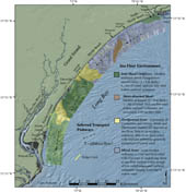 |
Figure 19. Map showing the four primary sea floor environments within Long Bay
Click on figure for larger image and full caption.
|
Integrated analysis of sidescan-sonar imagery, swath bathymetry, and surface sediment texture reveals a complex range of sea floor environments offshore of the Grand Strand. Through the work of this study and that of Baldwin and others (2004), the environments of the inner shelf are broadly characterized as: 1) inlet shoal complexes; 2) shore-detached shoals; 3) hardground areas; and 4) mixed zones (fig. 19).
Inlet Shoal Complexes
Inlet shoal complexes lie offshore of Waites Island, Myrtle Beach, Murrells Inlet, North Island and the mouth of Winyah Bay. With the exception of the shore-oblique shoal offshore of Myrtle Beach, all shoal complexes are associated with modern inlet systems (fig. 3). Baldwin and others (2004) show that these shoal complexes represent the greatest accumulation of modern sediment within the study area (figs. 3, 5, 7, 8, 9, 10), and unconformably overlie Cretaceous and Tertiary strata and Pleistocene channel-fill deposits (figs. 7 and 8).
The inlet shoal complex offshore of Waites Island is characterized by fine to medium sand, moderate to low backscatter, and a gently, seaward-dipping shoreface (fig. 6). Baldwin and others (2004) mapped up to 6 m of modern sediment within the shoal complex (fig. 3) and suggest that the relatively thick accumulation of sediment is associated with the Waites Island transgressive barrier and Little River and Hog Inlets that bound the island to the north and south, respectively.
Modern sediment deposits (~1 - 3 m thick) within the Murrells Inlet shoal complex (fig. 3) are characterized by uniform low backscatter and contain surficial sediments that predominately consist of fine sand (fig. 15). Where the surficial sediments are thin, underlying Pleistocene channel deposits are exposed at the sea floor. These exposures generally consist of coarse sand and are defined by complex patterns of high-backscatter that extend from the shoreface to the offshore extent of the survey area. Pleistocene deposits are also exposed in the troughs of a series of shore-oblique sand ridges superimposed on the larger shore-perpendicular shoals. Fine sands (< 3 m thick) comprise the low-backscatter ridge crests (figs. 4 and 15).
Baldwin and others (2004) mapped small shallow channels lying above the transgressive unconformity directly offshore of Murrells Inlet. The shallow channels show less cross-shelf continuity than the larger channels that cut into Cretaceous and Tertiary strata below the transgressive unconformity (Baldwin and others, 2004; 2006). While the larger channels have been interpreted to represent the result of downcutting by Pleistocene rivers during previous sea-level low-stands, the shallow channels are interpreted to represent younger drainage, including tidal creeks, tidal inlets and/or local swashes (Baldwin and others, 2004). The thick modern sediment deposits, presence of younger channels and proximity to the modern tidal-inlet indicate the Murrells Inlet shoal complex likely represents the landward retreat of the inlet system (Baldwin and others, 2004). The series of shore-oblique ridges cross-cutting the shoals suggests that sediments within the complex are being reworked by modern nearshore processes.
From Pawley's Island to the mouth of Winyah Bay, Pleistocene channel-fill deposits and Tertiary strata are exposed at the sea floor between thick deposits of modern sediment (figs. 3, 9 and 10) (Baldwin and others, 2004). The thickest sediment deposits are contained within low to moderate backscatter, shore-oblique ridges that extend across the survey area. Pleistocene channel-fill deposits are exposed within the adjacent troughs and display complex patterns of high-backscatter within the sidescan-sonar imagery (figs. 8, 9, and 10). Tertiary strata exposed at the sea floor in isolated locations offshore of Pawley's Island are also characterized by expanses of high backscatter. Surficial grain size distribution shows the region to be generally composed of coarse sand, with concentrations of medium sand along ridge crests and coarse sand within the trough (fig. 15). Proximity to the Winyah Bay estuary and the greater Santee Delta/Cape Romaine shoal complex probably accounts for the large accumulations of modern sediment within this portion of the study area. These sediments appear to be actively reworked by modern processes, as evidenced by the series of relatively large (> 3 m) shore-oblique ridges.
Shore-detached Shoals
The NE-SW trending shore-oblique low backscatter shoal offshore of Myrtle Beach is characterized by up to 3 m of well-sorted, medium sand and represents the only large accumulation of modern sediment on the inner shelf not associated with an active inlet system (Baldwin and others, 2004). Two of the larger swash systems in the region (Whitepoint and Singleton Swash) lie directly landward of the shoal (fig. 3). Upland morphology indicates that these swashes likely represent the remnants of a relict tidal inlet that could have provided the sedimentary source for the shore-detached shoal. Inshore of the shoal, Baldwin and others (2004) mapped shallow channels above the transgressive unconformity, and interpret their formation to drainage of back-barrier creeks, swash or tidal inlet systems. Calibrated radiocarbon dates, based on shell and organic material extracted from the upper ~1.2 - 1.5 m of the shoal deposit, constrain its age to Holocene (4070 +/- 40 BP - 8040 +/- 150 BP; P.T. Gayes, pers. comm.) (fig. 8, Appendix B1 and B2). Due to the presence of modern swash systems on the adjacent upland, younger channels inshore of the shoal, and the Holocene age of the shoal deposit, we interpret this feature to represent the remnants of an ebb-tidal delta complex produced by an inlet system that did not survive the most recent marine transgression.
|

 Back to Previous Section
 Forward to Next Section