Figure 4 shows an index map of the surveys that were combined to produce the database and maps of the gamma-ray data for the Big Bend study area. The shaded areas indicate areas where the data from the detailed survey were not useable because the height of the aircraft above the ground was too high to get valid measurements. In those areas the only data available were those from the regional survey. As a result the information within those areas is limited to a general indication of the gamma-ray characteristics of the geologic materials.
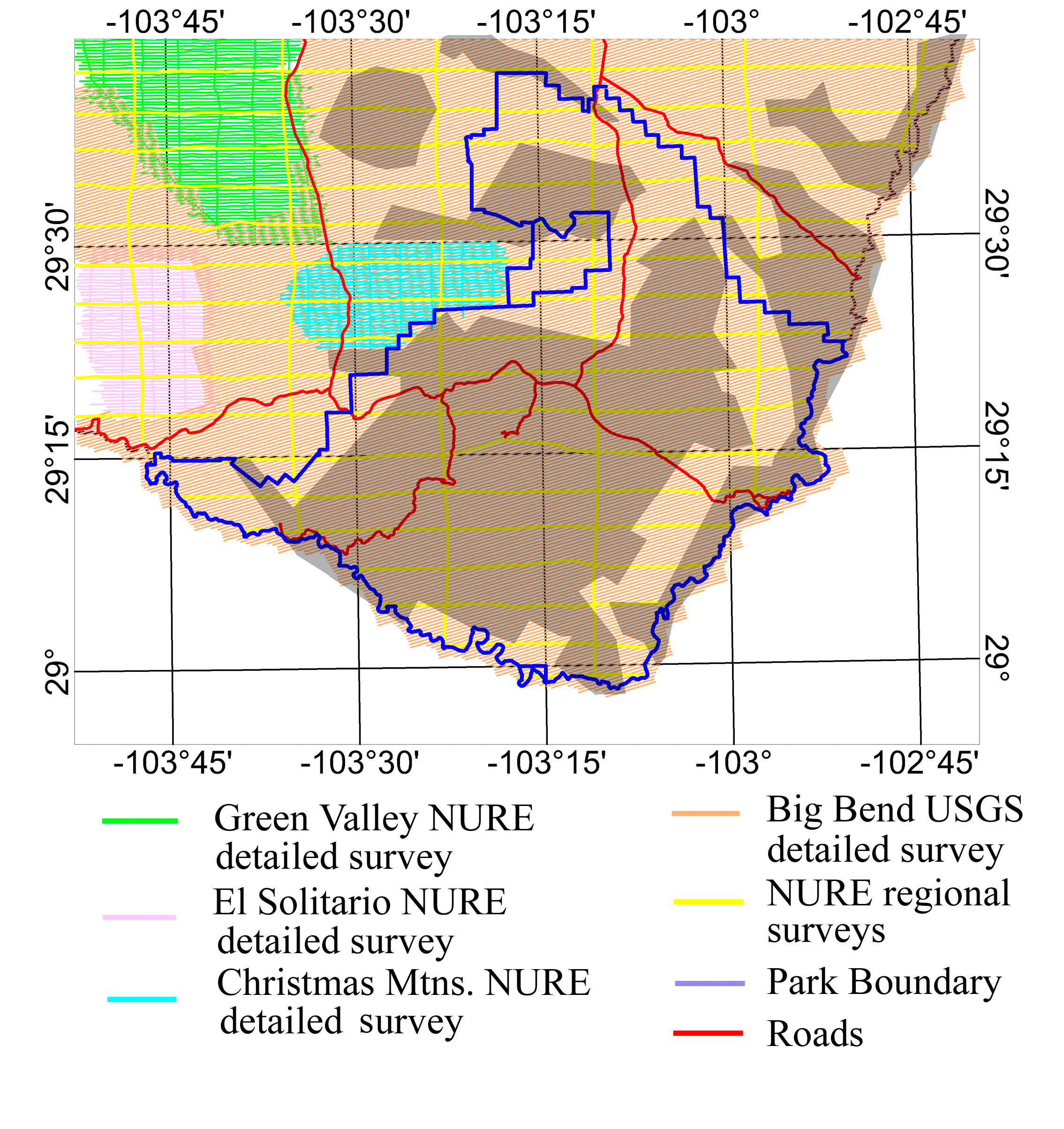
Figure 4. Index map showing the aerial gamma-ray surveys used for this report. Shaded areas indicate where data from the detailed survey were not useable because of high altitudes of the aircraft above the ground.
The surveys of the Christmas Mountains, El Solitario, and Green Valley areas are detailed surveys flown as part of the National Uranium Resource Evaluation (NURE) Program of the U.S. Department of Energy. These surveys were flown with east-west lines at a spacing of about 400 m and north-south tie lines spaced about 4 km apart. The NURE regional survey was flown with east-west lines at a spacing of about 5 km and north-south tie lines spaced about 10 km apart. The Big Bend USGS survey was flown with southwest-northeast lines spaced about 400 m apart. All of the surveys attempted to maintain a nominal elevation 122 m above the ground and they used sodium iodide detectors with large crystal volumes (33 - 50 L). The data for potassium, uranium, and thorium were based upon count rates measured in energy windows of the gamma-ray spectra. Figure 5 shows a gamma-ray spectrum with indicated energy windows used for potassium, uranium, and thorium.
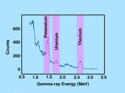
Figure 5. Typical sodium iodide spectrum showing energy windows used to measure gamma rays from the decay of potassium (K40), uranium (U238), and thorium (Th232) isotopes.
The measured count rates for potassium, uranium, and thorium were corrected by the contractors for cosmic and aircraft background, Compton scattering, airborne Bi214, and altitude variations. The corrected count rates were converted to estimated concentrations using calibration factors determined from measurements at calibration facilities. The systems used for the NURE surveys were calibrated using pads at Grand Junction, Colorado (Ward, 1978) and a test strip at Lake Mead, Nevada (Geodata International, Inc., 1977). The system used for the Big Bend USGS survey was calibrated using portable pads constructed by the Geological Survey of Canada (John Carson, personal communication) and a test strip near Bancroft, Ontario (Darnley and Grasty, 1969)
Because the decay series of uranium and thorium are complex with many different chemical elements, these series may not be in radioactive equilibrium. If the decay series are not in radioactive equilibrium, measurements of the activity of a daughter product will not reflect the activity of the parent nuclei. Because we are measuring gamma rays from daughter products of uranium (Bi214) and thorium (Tl208) and assuming radioactive equilibrium, we acknowledge the possibility of disequilibrium by denoting the concentrations of uranium and thorium as equivalent uranium (eU) and equivalent thorium (eTh).
Intro | Geology | Gamma-ray Data | Landsat Data | Maps | Discussion | Conclusions | Listing of Data Files | References | Tutorial

![]() U.S. Department of the Interior |
U.S. Geological Survey
U.S. Department of the Interior |
U.S. Geological Survey
URL: http://pubsdata.usgs.gov/pubs/of/2005/1371/html/gamdata.htm
Page Contact Information: Stephen Snyder
Page Last Modified: Saturday, 12-Jan-2013 21:45:03 EST