The gamma-ray data were processed using a maximum likelihood classification algorithm to group the data into gamma-ray units with statistically discrete signatures. An iterative approach was used to refine the statistical signatures associated with the units. After completion of the classification process, polygons were drawn around contiguous grid cells assigned to a particular unit. Figure 1 shows the resulting map and table 1 lists the mean values and standard deviations of the concentrations of potassium (K), uranium (eU), and thorium (eTh).
Comparison of this map with the geologic maps suggests that unit R1 is related to Tertiary intrusive rocks and Unit R2 is mostly associated with Santa Elena Limestone (Kse). Where R2 occurs around part of the El Solitario dome, the geologic map shows undifferentiated limestone units and the gamma-ray data suggest that the area identified as unit R2 might be used to differentiate Santa Elena Limestone from other limestone units in that particular area. Unit R3 is distinct from R2 only in the amount of uranium. R3 does not appear to be diagnostic of a particular geologic unit but most likely reflects the presence of limestone units or material derived from them. Unit R4 also does not seem to reflect any particular geologic unit. Unit R5 has concentrations (see table 1) consistent with those to be expected in sandstone, shale, or sandy alluvium. R5 is often associated with alluvial and fan deposits and exhibits an association with areas mapped as Boquillas Formation. Unit R6 has mean concentrations very similar to those of unit R8 (see table 1). Because they are not statistically very distinct, units R6 and R8 should be considered the same. These units appear to be related to intrusive rocks and materials derived from them. The largest area identified as units R6 and R8 in the southern part of the area coincides with the area where the density of the data is sparse (refer to the survey index map for areas of low resolution data). Outside of areas of sparse data, units R6 and R8 are related to intrusive rocks and might be considered part of unit R1. Unit R7 is similar to units R6 and R8 except for lower concentrations of potassium and may represent materials derived from intrusive rocks that are more radioactive. Unit R9 is also similar to units R6 and R8. Outside areas of sparse data, R9 is related to intrusive rocks and appears to be characteristic of an area mapped as Chinati Mountain caldera volcanic rocks (Ocm, refer to regional geologic map) in the northwest corner of the study area. Unit R10 occurs in areas mapped as alluvial and fan deposits and may be indicative of some areas mapped as undivided Bliss Sandstone and El paso Formation (OCe) on the regional geologic map. The observed concentrations are consistent with sandstone but not with the limestone and dolomite of the El Paso Formation. Unit R11 occurs in limited areas and is usually contiguous with unit R7. Unit R12 occurs mostly near intrusive rocks where unit R1 occurs and may reflect materials derived from them. Unit R13 is similar to unit R12 and generally occurs contiguous to it. Unit R14 occurs in only two areas in the eastern part of the study area. The largest of these areas lies within an area mapped as Boquillas Formation (Kbo). Boquillas Formation also outcrops within the smaller area of R14.
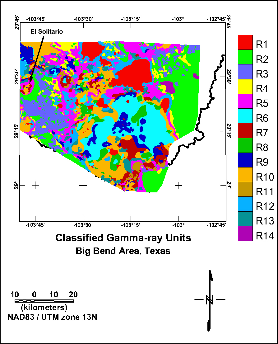
Figure 1. Map showing the gamma-ray map units defined using a maximum likelihood classification algorithm.
Table 1. Listing of the mean values and standard deviations of concentrations of potassium (K), uranium (eU), and thorium (eTh) for the gamma-ray map units.
|
|
Potassium (%) |
Uranium (ppm) |
Thorium (ppm) |
|||
|---|---|---|---|---|---|---|
|
Group |
Mean |
Std. Dev. |
Mean |
Std. Dev. |
Mean |
Std. Dev. |
|
1 |
3.9 |
0.7 |
1.9 |
0.5 |
8.6 |
1.6 |
|
2 |
0.4 |
0.2 |
1.4 |
0.4 |
2.3 |
1.0 |
|
3 |
0.4 |
0.2 |
2.5 |
0.5 |
2.9 |
0.9 |
|
4 |
0.8 |
0.2 |
2.0 |
0.3 |
3.2 |
0.7 |
|
5 |
1.4 |
0.3 |
2.3 |
0.7 |
6.5 |
1.4 |
|
6 |
3.5 |
0.3 |
3.5 |
0.9 |
18.5 |
4.8 |
|
7 |
2.0 |
0.3 |
3.2 |
1.5 |
12.7 |
3.6 |
|
8 |
3.7 |
0.4 |
3.3 |
0.7 |
13.4 |
1.1 |
|
9 |
2.8 |
0.6 |
3.1 |
0.9 |
16.7 |
5.1 |
|
10 |
2.7 |
0.4 |
2.7 |
0.7 |
10.9 |
1.4 |
|
11 |
1.4 |
0.4 |
3.3 |
0.7 |
9.5 |
2.1 |
|
12 |
2.1 |
0.4 |
1.7 |
0.5 |
6.5 |
1.7 |
|
13 |
2.0 |
0.3 |
2.0 |
0.5 |
9.1 |
1.1 |
|
14 |
0.5 |
0.1 |
1.7 |
0.1 |
1.6 |
0.3 |
Gamma-ray Data | Subarea Index | Subarea 1 | Subarea 2 | Subarea 3
Intro | Geology | Gamma-ray Data | Landsat Data | Maps | Conclusions | Listing of Data Files | References | Tutorial

![]() U.S. Department of the Interior |
U.S. Geological Survey
U.S. Department of the Interior |
U.S. Geological Survey
URL: http://pubsdata.usgs.gov/pubs/of/2005/1371/html/Radclass.htm
Page Contact Information: Stephen Snyder
Page Last Modified: Saturday, 12-Jan-2013 21:45:14 EST