U.S. Geological Survey Open-File Report 2008-1206
Coastal Change Along the Shore of Northeastern South Carolina: The South Carolina Coastal Erosion Study
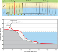
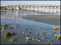
5.2 Sediment SourcesSediment in the active beach system is derived from 1) erosion of upland by rivers, 2) longshore transport from adjacent coastal compartments, 3) erosion of older beach and shoreface deposits, and 4) erosion of older deposits on the inner shelf. The sum of the deposits from all of these sources represents the input of new sediment into the active beach system. Although the amounts of sediment contributed by the sources are difficult to quantify accurately, we provide a general accounting of their contributions. Sediment Delivered by Rivers Fluvial input to the coastal system is limited to areas at the northern and southern boundaries of Long Bay. In the north, the Cape Fear River enters Long Bay at Cape Fear. In the south, the Great Pee Dee River coalesces with several smaller rivers near Georgetown to form a large estuary at Winyah Bay. Dams on these rivers largely block the movement of sediment, however, and most of the sediment that does makes it downstream is trapped in Winyah Bay before it reaches the coast (Meade and Trimball, 1974; Patchineelam and others, 1999). Extensive deposits of mud are dredged routinely to maintain shipping channels in upper parts of Winyah Bay and the Cape Fear River estuary. The limited amount of fluvial sediment that is transported beyond the estuaries appears to be incorporated into shoal complexes offshore of Cape Fear and Cape Romain. Sediment Delivered by Longshore Transport Geomorphic evidence suggests that little or no sediment is exchanged around the capes that separate Long Bay from coastal compartments to the north and south. Extensive southerly spit growth at the Winyah Bay entrance indicates a dominance of southerly longshore transport, which limits any contribution of sediment moving north into Long Bay. Sand spits and the associated shoal complex offshore of Cape Fear appear to be the dominant regional sediment sinks, which effectively trap sediment that might enter Long Bay from the north (Denison, 1998). Erosion of Beach and Shoreface Deposits The contribution of sediment from beach and shoreface erosion is estimated by analyzing beach-profile geometries and historical erosion rates (Gayes and others, 2003). First, the coast is divided into about 950 segments that measure 100 m (330 ft) wide, and cover the entire Grand Strand coastline (Figure 5.2). Each segment is assigned a beach profile defined as the closest BERM profile, typically located within 200 m (660 ft) of each segment. The assigned profile for each segment is translated landward according to the long-term erosion rate for that segment of beach. We assume that the translated profile maintains a constant shape over the long term (decades or longer), although slight variations probably occur over the short term (months to years). The difference between the translated and existing profile in each segment is calculated to represent the volume of sediment derived by this idealized migration. Volumes are added for all segments and presented as an annualized average for the region (Table 5.1). Based on this analysis, erosion of the beach and shoreface along the entire Grand Strand has released an average of 104,000 m3/yr (136,027 yd3/yr) of sediment. This volume of sand is a maximum estimate because deposits underlying large areas of the beach contain abundant muddy sediment, and its erosion yields relatively less sand-sized sediment. Erosion of Inner-Shelf Deposits A considerable proportion of sediment in the modern coastal system is derived from the erosion of older materials underlying the inner shelf. Wehmiller and others (1995) provide evidence of this process by showing that up to 75 percent of clam shells found on beaches in the region are actually fossils. The clams lived more than 10,000 years ago and, after death, were preserved in rocky deposits that underlie parts of Long Bay. Biological and physical processes actively rework these deposits on the inner shelf, providing recycled sediment to the modern coast. In nearby Onslow Bay, NC, Riggs and others (1998) have calculated that bioerosion of hardbottoms yields as much as 5.5 kg/m2 (1.1 lb/ft2) of new sediment each year. Large waves can excavate fragments of the rocky material from the inner shelf and wash them up onto Grand Strand beaches (Figure 5.3). Soft corals and other invertebrates are often still attached to the rock fragments on the beach after storms. These types of organisms typically live more than 1 km (0.6 mi) offshore of the surf zone; in this offshore area, waves and sediment abrasion are less intense. Their presence on the beach indicates inner-shelf erosion and onshore transport during intense storm events. The volume of sediment derived from the inner shelf is estimated as 391,000 m3/yr (511,409 yd3/yr). This value was indirectly calculated and represents the residual or remaining volume of sediment needed to balance the total losses in the budget (Table 5.1). The net onshore transport of sediment is driven by unexplained processes, but the estimated volume of inner-shelf sediment, at this regional scale, is not excessive. It represents only a fraction of the sediment that is available on the inner shelf as a potential source of beach sediment. Based on geologic mapping, at least 270 million m3 (353 million yd3) of mobile sediment exists on the inner shelf (Figure 3.5b). This large reservoir of sediment can readily account for the deficit in the sediment budget. Next Section: 5.3 Sediment Sinks » |

 U.S. Department of the Interior |
U.S. Geological Survey
U.S. Department of the Interior |
U.S. Geological Survey
URL: https://pubsdata.usgs.gov/pubs/of/2008/1206/html/processes2.html
Page Contact Information: Publishing Service Center
Page Last Modified: Monday, 03-Jun-2019 11:36:40 EDT