U.S. Geological Survey Open-File Report 2008-1206
Coastal Change Along the Shore of Northeastern South Carolina: The South Carolina Coastal Erosion Study
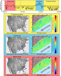
5.5 Numerical ModelingNumerical models developed as part of the SCCES show that offshore bathymetric features, such as the sandy shoal seaward of Myrtle Beach (Figure 5.5), affect nearshore processes through the modification of waves that pass over them. The direction and magnitude of sediment transport on the inner shelf are influenced by different patterns of storms that pass through South Carolina: 1) tropical cyclones (that is, tropical storms and hurricanes), 2) cold fronts, and 3) warm fronts (Figure 5.6). Storms develop because the atmosphere contains regions of high and low pressure that move across North America. Winds blow counterclockwise around low-pressure systems, bringing cooler air to the south and warmer air to the north. As these air masses move, they create a cold front to the south of the low pressure and a warm front that extends to the east from the low pressure. The duration, magnitude, and frequency of the different storm types dictate the long-term sediment flux in the region. Cold fronts and warm fronts generally drive sediment transport toward the northeast; tropical storms generally drive it to the southwest (Figure 5.6). If transport is roughly equal in both directions, it provides a potential mechanism for partially preserving the sandy shoal, which somehow has survived erosion over the last 5000 years or so since it was formed (Barnhardt and others, 2007). Instead of storms moving sediment in one consistent direction and eventually eroding the shoal, these observations suggest that storms could have shifted sediment back and forth across the shelf. Additional modeling will help us identify the oceanographic processes responsible for maintaining the large shoal and explore possible sediment pathways connecting the shoal to the beach. Next Section: 5.6 Summary » |

 U.S. Department of the Interior |
U.S. Geological Survey
U.S. Department of the Interior |
U.S. Geological Survey
[an error occurred while processing this directive]
URL: https://pubsdata.usgs.gov
Page Contact Information: Publishing Service Center
Page Last Modified: Wednesday, 07-Dec-2016 21:39:08 EST