U.S. Geological Survey Open-File Report 2008-1206
Coastal Change Along the Shore of Northeastern South Carolina: The South Carolina Coastal Erosion Study
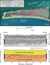
5.3 Sediment SinksOn a regional scale, potential sinks for sediment from the beach system include adjacent coastal compartments, into which sediment is transported across the southern or northern boundary, and the inner shelf, to which sediment is transported offshore. The sum of the sediment volumes lost into all of these sinks represents the total loss of sediment from the active beach system. Geologic mapping and analysis of dredging records provide estimates of the annual rate of sediment loss and where it is going. Losses Across the Southern Boundary Significant sediment transport out of the Grand Strand is evident across the southern boundary at Winyah Bay. The bay lies behind North Island spit, a sandy peninsula about 5 km (3 mi) long and 1 km (0.6 mi) wide (Figure 5.4). Progressive elongation of the spit deflected the Winyah Bay entrance channel about 1 km (0.6 mi) to the south between 1872 and 1983 (Anders and others, 1990; Morton and Miller, 2005). The spit deposits represent an estimated volume of 9 million m3 (11.8 million yd3) based on data from cores, ground-penetrating radar, and topographic surveys. Over the 111 years of spit growth, we estimate that about 79,000 m3/yr (103,328 yd3/yr) of sediment was lost from the Grand Strand (Table 5.1). Sandy sediment also fills the entrance channel to Winyah Bay, where a jetty system was constructed to stabilize and maintain the shipping lanes into the Port of Georgetown. Regular dredging is required to keep the channel open for navigation. Based on maintenance-dredging projects completed between 1994 and 2002, the annual rate of deposition in the channel and lower bay is 284,000 m3/yr (371,458 yd3/yr). Most of this material probably was delivered by southerly directed longshore transport out of Long Bay (Patchineelam and others, 1999). Losses Across the Northern Boundary Studies by the U.S. Army Corps of Engineers (USACE) suggest that longshore transport is small and more variable across the northern boundary of Long Bay at Little River Inlet. Based on measurements recorded over short time periods, the initial modeling reported limited net annual transport towards the northeast out of the Grand Strand system (Chasten, 1992). Some of the northward-transported sediment apparently is accumulating at Waites Island. The formation of beach ridges indicates seaward growth of the island and a net surplus of sand (Figure 4.3B). Dredging records from Little River Inlet prior to construction of jetties in 1982 show small net losses of sediment moving into Onslow Bay off the coast of North Carolina (Figure 1.3A). An average of 57,000 m3/yr (74,553 yd3/yr) of sediment was dredged from the navigation channel between 1975 and 1982. This value is used to estimate sediment lost across the northern boundary by longshore transport. Losses at Tidal Inlets Tidal inlets function as reservoirs that temporarily store and release sediment within the regional system. Net changes in the volumes of sediment contained in the inlet systems strongly affect the stability of adjacent beaches over the short term. In addition to inlets at the boundaries of the Grand Strand, Hog and Murrells Inlets are probably sites of net sediment loss from the beach system (Figure 5.1). Based on dredging records for 1974–1978, about 75,000 m3/yr (98,096 yd3/yr) of sediment is lost at Murrells Inlet. No dredging data are available for Hog Inlet to estimate sediment losses. Losses Offshore to the Inner Shelf Extensive areas of hardbottom dominate the inner shelf of Long Bay (Figures 2.4 and 2.5). Seaward of Surfside Beach, for example, is a nearly continuous area of rocky outcrops extending offshore for about 10 km (6 mi). Small lenses of loose sediment within this zone probably are derived from biological and mechanical erosion of the outcrops, as has been observed elsewhere in the region (Riggs and others, 1998). The near-absence of modern sediment suggests that transport of sediment from the beach to the inner shelf is small. Alternatively, the mobile sediment is being moved quickly into deeper water beyond the limit of the survey area. Next Section: 5.4 Sediment-Transport Pathways » |

 U.S. Department of the Interior |
U.S. Geological Survey
U.S. Department of the Interior |
U.S. Geological Survey
URL: https://pubsdata.usgs.gov/pubs/of/2008/1206/html/processes3.html
Page Contact Information: Publishing Service Center
Page Last Modified: Monday, 03-Jun-2019 11:36:41 EDT