U.S. Geological Survey Open-File Report 2008-1206
Coastal Change Along the Shore of Northeastern South Carolina: The South Carolina Coastal Erosion Study
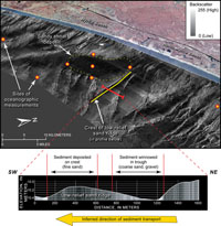
5.4 Sediment-Transport PathwaysThe relatively minor amount of mobile sediment in Long Bay is moved by waves and currents in a complex pattern. On a broad regional scale, seafloor mapping helps us infer the long-term directions of sediment transport based on geomorphic evidence and sediment distribution. However, formulation of a quantitative sediment budget is not possible with mapping techniques alone. Most sediment movement occurs during short-lived, energetic storm events. Direct observations of oceanographic processes (for example, the speed and direction of bottom currents) are needed to quantify how much and in what direction sediment is moved during a storm or series of storms. Knowledge of the actual rates and pathways of sediment transport helps us to predict patterns of erosion/accretion along the beach and determine the availability of sediment for planned beach-renourishment projects. Transport Direction Inferred from Seafloor Mapping Several lines of evidence suggest that sediment generally moves along the coast from north to south. First, the Pee Dee River has migrated in a southerly direction for over a million years (Baldwin and others, 2006) and has thereby shifted the major supply of fluvial sediment away from the center of the Grand Strand (Figure 3.9). Consequently, the central and northern parts of the Grand Strand now depend primarily on the reworking of relict-shoreline and inner-shelf deposits for sediment supply. Second, sediment-thickness mapping shows relatively little mobile sediment in the northern and central parts of the Grand Strand, with the largest accumulations in the south (Figure 3.5B). Third, long-term net sediment transport is inferred from low-relief sand ridges on the inner shelf (Figure 5.5). Profile asymmetry and changes in sediment texture show current winnowing in the troughs between the sand bodies and support conceptual models of sediment moving south along the coast towards Winyah Bay. These characteristic patterns are indicative of sediment-transport pathways and are being used to guide process-oriented studies. Offshore-directed losses of sediment from Grand Strand beaches are not assigned an estimate for this sediment budget. Sediment is probably transported offshore in some areas, but little data are available to prove that it moves across the shelf. Slightly elevated rocky ledges oriented nearly perpendicular to the shoreline (Figure 2.5) might divert sediment seaward and thereby contribute to locally high rates of erosion (Gayes and others, 2003). Direct Observations of Sediment Transport An initial study in 2001 measured waves and currents for periods of over 30 days at six locations in Long Bay. The data were helpful in determining the general circulation in the bay and the response of the system to local winds (Gutierrez and others, 2006). In a second study, instruments were deployed from October 2003 to April 2004 offshore of Myrtle Beach to investigate sediment movement on the inner shelf (Figure 5.5). Measurements of winds, currents, waves, and suspended sediment concentrations were collected at eight sites in the vicinity of a large sandy shoal that lies in water depths of about 10 m (33 ft). Given the importance of finding sand resources for beach nourishment, this deposit might be suitable for sand extraction. Before dredging the deposit, however, some important questions need to be addressed. Is the resource renewable? Will inner-shelf processes replace sediment that is mined? Will dredging change the distribution of wave energy along nearby stretches of coastline and cause unwanted erosion? Preliminary results show that local wind events strongly correlate with peaks in wave energy. As wind strength increases during a storm, wave heights increase (Figure 2.11). Large waves create orbital motions at the sea surface that propagate downward and oscillate along the seafloor. These motions erode bottom sediment and suspend it in the water column during storms. Suspended sediment concentrations are only increased when there are large waves; tidal currents alone are not strong enough to mobilize the sediment. A combination of wind-driven surface currents and near-bottom circulation determines the direction and magnitude of sediment transport within Long Bay. Details of the site locations, equipment specifications, all the processed data, and the processing tools are described in Sullivan and others (2006). Next Section: 5.5 Numerical Modeling » |

 U.S. Department of the Interior |
U.S. Geological Survey
U.S. Department of the Interior |
U.S. Geological Survey
URL: https://pubsdata.usgs.gov/pubs/of/2008/1206/html/processes4.html
Page Contact Information: Publishing Service Center
Page Last Modified: Monday, 03-Jun-2019 11:36:42 EDT