U.S. Geological Survey Open-File Report 2009-1072
Geophysical and Sampling Data from the Inner Continental Shelf: Duxbury to Hull, Massachusetts

|
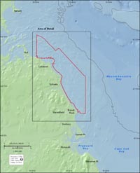
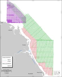
This report presents high-resolution maps and spatial data for the seafloor offshore of Massachusetts, between Duxbury and Hull (fig. 1). Approximately 200 square kilometers (km²) of the inner continental shelf was mapped with a focus on areas inside the 3-mile limit of State jurisdiction. Water depths ranged from 2 to 38 m. The maps are the fourth in a series (Barnhardt and others, 2006, 2009; Ackerman and others, 2006) produced by a cooperative mapping program of the U.S. Geological Survey (USGS) and the Massachusetts Office of Coastal Zone Management (CZM). The marine geophysical data, sediment samples, and bottom photography in this report were obtained during three USGS research cruises in 2006 and 2007 and one National Oceanic and Atmospheric Administration (NOAA) hydrographic survey in 2003 (fig. 2). Existing data, collected by NOAA to update navigation charts in the region, have been used throughout this mapping program to help characterize seafloor geology and morphology whenever possible. The long-term objectives of this mapping program are to build a foundation for scientific research and to provide geologic information for management of coastal and marine resources. Accurate maps of seafloor geology are important first steps toward protecting fish habitat, delineating marine resources, and assessing environmental changes caused by natural or human impacts. This report documents the data collection and processing methods and provides access to the data. Available datasets include bathymetry, acoustic backscatter intensity, seismic reflection, textural analyses of sediment samples, and bottom photographs. These data products are integrated within a Geographic Information System (GIS) to form the basis for interpretive geologic maps that will be published for this region and help guide future management decisions. The inner continental shelf offshore of this section of the Massachusetts coast is a high-relief, glaciated seafloor. The general configuration of the shoreline and inner shelf is controlled by the lithology and structural features of the region’s underlying bedrock. Multiple episodes of glacial erosion modified the bedrock framework and deposited unconsolidated sediment to form moraines, drumlins, and other glacial landforms. Following deglaciation, relative sea-level change has been the major process shaping the coast and inner shelf over the last 14,500 years (Oldale and others, 1993). Shoreline transgression and regression have reworked a wide expanse of the inner shelf and largely removed fine-grained sediment from the seafloor in water depths of less than about 50 meters (m). These shallow, nearshore areas are characterized by rugged rock outcrops and relatively thin, discontinuous deposits of coarser grained sediment that ranges in size from sand to gravel and large boulders. Erosion of these glacial deposits provides most of the new sediment that builds beaches and marshes along this stretch of coast. |