U.S. Geological Survey Open-File Report 2010–1005
Surficial Geology of the Sea Floor in Long Island Sound Offshore of Plum Island, New York
![]() Title |
List of Figures |
Conversion Factors |
Abstract |
Introduction |
Setting |
Methods |
Bathymetry |
Sidescan Sonar |
Sediments |
Bottom Photography |
GIS Data Catalog |
Summary |
Acknowledgments |
References |
Contacts
Title |
List of Figures |
Conversion Factors |
Abstract |
Introduction |
Setting |
Methods |
Bathymetry |
Sidescan Sonar |
Sediments |
Bottom Photography |
GIS Data Catalog |
Summary |
Acknowledgments |
References |
Contacts
 |
||
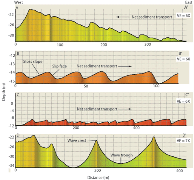
Figure 17. Sand-wave profiles of waves on shoal north of Plum Island. Arrows show direction of net sediment transport. Profile A-A' shows waves with asymmetries suggesting a westward net sediment transport. Profiles B-B' and C-C' show waves with asymmetries suggesting an eastward net sediment transport. Profile D-D' shows waves that are symmetrical and are probably not moving. Vertical exaggeration is 6X in profiles A-A', B-B', and C-C' and 7X in profile D-D'. Locations of profiles shown in figure 16. | ||

![]() U.S. Department of the Interior |
U.S. Geological Survey
U.S. Department of the Interior |
U.S. Geological Survey
URL: https://pubsdata.usgs.gov/pubs/of/2010/1005/html/fig17.html
Page Contact Information: Contact USGS
Page Last Modified: Wednesday, 07-Dec-2016 22:35:35 EST


