U.S. Geological Survey Open-File Report 2010–1005
Surficial Geology of the Sea Floor in Long Island Sound Offshore of Plum Island, New York
![]() Title |
List of Figures |
Conversion Factors |
Abstract |
Introduction |
Setting |
Methods |
Bathymetry |
Sidescan Sonar |
Sediments |
Bottom Photography |
GIS Data Catalog |
Summary |
Acknowledgments |
References |
Contacts
Title |
List of Figures |
Conversion Factors |
Abstract |
Introduction |
Setting |
Methods |
Bathymetry |
Sidescan Sonar |
Sediments |
Bottom Photography |
GIS Data Catalog |
Summary |
Acknowledgments |
References |
Contacts
 |
||
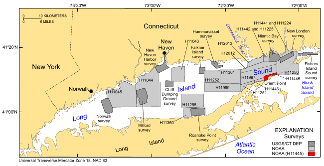
Figure 1. Index map of Long Island Sound study area, U.S. Geological Survey (USGS)/Connecticut Department of Environmental Protection (CT DEP) surveys, and National Oceanic and Atmospheric Administration (NOAA) hydrographic surveys. NOAA hydrographic surveys include: H11250--Poppe and others (2006c, 2007b); H11255--Poppe and others (2006b); H11252/H11361--Poppe and others (2007a, 2008); H11043--Poppe and others (2004); H11044--McMullen and others (2005), Poppe and others (2006a); H11045--Beaulieu and others (2005). USGS/CT DEP sidescan-sonar surveys include: Norwalk--Twichell and others (1997); Milford--Twichell and others (1998); New Haven Harbor and Central Long Island Sound (CLIS) dumping grounds--Poppe and others (2001); Roanoke Point--Poppe and others (1999b); Falkner Island--Poppe and others (1999a); Hammonasset--Poppe and others (1997); Niantic Bay--Poppe and others (1998b); New London--Lewis and others (1998), Zajac and others (2000, 2003); Fishers Island Sound--Poppe and others (1998a). | ||

![]() U.S. Department of the Interior |
U.S. Geological Survey
U.S. Department of the Interior |
U.S. Geological Survey
URL: https://pubsdata.usgs.gov/pubs/of/2010/1005/html/fig1.html
Page Contact Information: Contact USGS
Page Last Modified: Wednesday, 07-Dec-2016 22:35:29 EST


