Open-File Report 2011-1039
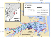
IntroductionIndian River Bay, Delaware, is located along the eastern shore of the Delmarva Peninsula. The bay and its watershed have been studied previously by numerous researchers because of its severe eutrophication issues and the identified role of submarine groundwater discharge as a major source of nitrogen delivery (Andres, 1992; Roy F. Weston, Inc., 1993; Delaware Department of Natural Resources and Environmental Control, 1995; Böhlke and Krantz, 2003; Bratton and others, 2004; Krantz and others, 2004; Manheim and others, 2004; Scudlark and others, 2005; Wang and others, 2008). A new multi-investigator project to measure and model elements of the Indian River Bay groundwater system began in 2009. From April 13 to 15, 2010, the initial phase of delineation of the fresh-saline groundwater interface and associated sub-bottom sedimentary structures beneath Indian River Bay was performed (fig. 1). The effort included surveying at higher spatial resolution in the vicinity of a study site at Holts Landing along the south-central shoreline of the bay, a location where offshore multi-level wells were later installed and seepage meter studies were performed. Some onshore wells had already been installed at that site by Delaware Geological Survey crews. The total length of continuous resistivity profiling (CRP) survey lines was 154 kilometers (km), with 33 km of coincident chirp seismic-reflection data collected around the perimeter of the bay on the first day of surveying. Medium-resolution CRP surveying was achieved using a 50-meter (m) streamer in a baywide grid (fig. 1). Underway salinity, temperature, and bathymetry measurements were also collected to permit processing and display of CRP data. The maximum tidal range in Indian River Bay during the survey was approximately 1 m; the average water depth was less than 2 m. |

![]() U.S. Department of the Interior |
U.S. Geological Survey
U.S. Department of the Interior |
U.S. Geological Survey
URL: http://pubsdata.usgs.gov/pubs/of/2011/1039/html/ofr2011-1039-intro.html
Page Contact Information: GS Pubs Web Contact
Page Last Modified: Monday, 04-Aug-2014 14:45:58 EDT