Skip past header information
USGS - science for a changing world

Open-File Report 2011-1039
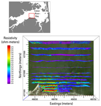
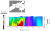

Continuous Resistivity Profiling and Seismic-Reflection Data Collected in April 2010 From Indian River Bay, Delaware


Skip past contents information

Click on figure for larger image.

Thumbnail image for Figure 5, oblique view of a horizontal slice through a 3D model of CRP data in Indian River Bay, Delaware, and link to a larger image.

Figure 5. Oblique view of a horizontal slice through a three-dimensional model developed using continuous resistivity profiling data from the Indian River Bay collected in April 2010.

Thumbnail image for Figure 6, perspective view from above of resistivity data off Holts Landing in Indian River Bay, Delaware, and link to larger image.

Figure 6. Perspective view from above of continuous resistivity processed data from the shore-parallel surveys collected off Holts Landing.

Thumbnail image for figure 7, cross-section view of a vertical slice through a 3D model of resistivity data off Holts Landing in Indian River Bay, Delaware, and link to larger image.

Figure 7. Cross-section view of a vertical slice through a three-dimensional model of the continuous resistivity profile data. The perspective is facing offshore (north). A high-resistivity (fresh groundwater represented by red colors) anomaly to the left (west) lies beneath a filled paleochannel shown in figure 8.

Thumbnail image for Figure 8, chirp seismic-reflection profile off Holts Landing in Indian River Bay, Delaware,, and link to larger image. This profile corresponds the the resistivity vertical slice in Figure 7.

Figure 8. Chirp seismic-reflection profile collected near the Holts Landing shoreline along the same traverse and with the same perspective as figure 7. The seismic profile shows a complex paleochannel 2 to 4 meters deep on the left side of the image (west), which corresponds with the position of the high-resistivity anomaly shown in figure 7.

Summary

Results of the continuous resistivity profiling and concurrent chirp seismic surveys and data inversion show the presence of many buried paleochannels beneath Indian River Bay that generally extend perpendicular from the shoreline in areas adjacent to modern tributaries, tidal creeks, and marshes (fig. 5).  An especially wide and deep paleochannel system was imaged in the southeastern part of the bay near White Creek.  Many (but not all) paleochannels also had high resistivity anomalies (low-salinity groundwater plumes) associated with them.  One such association near Holts Landing is shown in figures 6, 7, and 8.  Results of additional seismic and electrical resistivity surveys performed by the University of Toledo are described separately (Banaszak, 2011).  Subsequent intensive sampling, measurements using seepage meters, installation of offshore and onshore wells, and modeling were performed in 2010 through 2012 (Michael and others 2011a, 2011b; Fernandez and others, 2011; Russoniello and others, 2013).  Results were generally consistent with geophysical data reported here.


Accessibility FOIA Privacy Policies and Notices

Take Pride in America logo USA.gov logo U.S. Department of the Interior | U.S. Geological Survey
URL: http://pubsdata.usgs.gov/pubs/of/2011/1039/html/ofr2011-1039-summary.html
Page Contact Information: GS Pubs Web Contact
Page Last Modified: Thursday, 24-Jul-2014 10:58:50 EDT