
|
| Click on figures for larger images. |
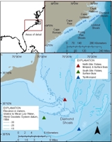 |
Figure 1. Figure 1 caption. Location map for Cape Hatteras, North Carolina. Markers are placed to identify locations of moorings. |
The U.S. Geological Survey (USGS) Coastal and Marine Geology Program in Woods Hole, Massachusetts, is leading an effort to understand the regional sediment dynamics along the coastline
of North and South Carolina. As part of the Carolinas Coastal Change Processes Project, the interactions among oceanographic forcing, geologic conditions, and the resulting
changes to topography in the inner shelf, nearshore, and subaerial beach regions are being examined. This Open-File Report provides an overview and detailed description, and presents data from, an oceanographic field
study, January - May 2009 to investigate processes that control the dynamics of sediment-transport at Diamond Shoals, North Carolina.
The Carolinas region is an ideal location in which to investigate sediment-transport processes and the interaction among the offshore and the nearshore. The most prominent morphologic features along the shoreline of the Carolinas are its four capes and three shoals. From north to south, Cape Hatteras (Diamond Shoals), Cape Lookout (Lookout Shoals), Cape Fear (Frying Pan Shoals), and Cape Romain segment the coastline into the northern outer banks, Raleigh Bay, Onslo Bay, and Long Bay regions. Continental shelf areas seaward of the capes are characterized by large, highly dynamic shoal complexes, which influence coastal circulation patterns and represent navigational hazards. These shoals contain a substantial percentage of the total volume of sediment in the overall coastal system (including the barrier islands, subaerial capes, shoreface, and cape-associated shoals). The shoals are generally thought to be the major sink in the coastal sediment-transport system. Understanding the formation of these capes and their effects on regional sediment-transport is important for management of our coastal waters.
Tripods were deployed at three sites along the outer perimeter of Diamond Shoals seaward of Cape Hatteras, North Carolina. Instruments were mounted on the tripods to measure surface waves, pressure, current velocity, bottom turbulence,
suspended-sediment profiles, and sea-floor sand-ripple bedforms; one tripod also held a visual camera system. Sites were chosen to the north, south, and east of the shoal to capture the oceanographic and sediment-transport
processes responsible for maintaining the offshore sand shoal.
|


